Sea Breezes
Sea Breezes. Circulations, Forecasting, & More!. METEO 416/516 Matthew Greenstein March 31, 2004. Overview. Pressure gradient-driven wind from cooler water to warmer land Onset of sea breeze = sea breeze front

Sea Breezes
E N D
Presentation Transcript
Sea Breezes Circulations, Forecasting, & More! METEO 416/516 Matthew Greenstein March 31, 2004
Overview • Pressure gradient-driven wind from cooler water to warmer land • Onset of sea breeze = sea breeze front • Front acts as a shallow cold front – a forcing mechanism for thunderstorms • Temperatures fall with its passage
Overview March 26, 20043PM
Overview ACY: 42oF on March 26
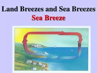
Circulation Solenoid Circulation • Land heats more than water due toa smaller heat capacity • Hydrostatic high and low pressures form
Circulation Mid - Late Morning • Sea Breeze begins once T(land)-T(water) > 6-10oF • Strength of the sea breeze is related to… • the temperature gradient between land and ocean • the synoptic flow • weak onshore inland penetration • moderate offshore prevents sea breeze • Some Cu form along the front
Circulation Noon • Pressure over land decreases further • Pressure gradient force increases • Surface winds of 10-15 knots at the shoreline • Solenoidal circulation: 1500 to 3000 feet deep • Lake & River Breezes: Similar setup but weaker & less penetration inland
Circulation Afternoon • Wind increases as pressure gradient increases • Temperature falls of 5oF to even 25oF possible with passage of sea breeze front • Depending on synoptic scale setup and other modifying factors (to be discussed later), the sea breeze pushes inland • Depending on stability and available moisture, more Cu form and grow deeper
Circulation Afternoon (cont’d) • Depending on stability and available moisture, thunderstorms can develop – especially if the sea breeze front interacts with other fronts, convergence zones, outflows, and other sea breezes • Florida: Sea breezes off of the Atlantic & Gulf coasts, river breeze off the Banana River near Cape Canaveral, & lake breeze off Lake Okeechobee • Onshore advance of marine stratus on West Coast
Circulation Evening & Night • Solenoid circulation gone 1 to 2 hours after sunset • Land cools Land breeze Nocturnal convection over water
Modifications Coastline concavity • Convex coastline focuses convergence and enhances the lift along the sea breeze front • Concave coastline leads to divergence and a reduction in the lift along the sea breeze front
Modifications Low-level inversion • Limits the vertical extend of heating, which reduces the strength of the sea breeze • Deeper moderate temperature rise leads to a stronger sea breeze than a shallow large temperature rise stronger hydrostatic low pressure and a greater pressure gradient
Modifications Synoptics • Weak offshore flow (< 10 knots): sea breeze can form with enough heating • Offshore flow > 10 knots: sea breeze won’t form • Weak flow in any direction: sea breeze can form • Strong along-shore flow can be turned with diurnal heating • LOW over land and HIGH over water is needed • HIGH over land and LOW over water will not turn properly • Strong on-shore flow will cool temperatures well-inland without any sea breeze
Modifications Synoptics
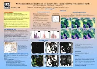
Numerical Models • All models create sea breezes, but… • Resolution determines the placement and strength • MM5 does a good job • Since temperature gradient is only a few km wide, you’d need a 1-km resolution model to resolve the gradient properly • Gradient is smoothed weaker pressure gradient weaker winds
Numerical Models • Resolution also affects how well coastline is modeled • Model will successfully predict if a sea breeze should develop, but details are not well forecast • See how well the models does in your forecasting area over time
Forecasting • Check the land-to-ocean forecasted temperature gradient – needs to be at least 6-10oF • Synoptic-scale flow needs to be weak, although onshore flow will, of course, lower temperatures • Know your coastline ! • Use models as a guide to possible sea breeze formation • Dr. Markowski says to anticipate a sea breeze if… • |vg |2 / ΔT < 5
Real-time Forecasting Clear-air Mode Radar
Real-time Forecasting Visible Satellite Imagery --------- Clear skies after front passage & Cu/Cb along front
Real-time Forecasting • Use a station model plot! • Look for the change in wind direction & temperature • This works especially well if you have a mesonet or tightly packed ASOS stations.
Upwelling • Upwelling leads to cooler water coming to the surface • This increases the land-ocean temperature gradient promotes and strengthens the sea breeze • Can occur in localized areas, creating kinks in the sea breeze • Prolonged SW’erly flow off NJ, leads to upwelling
Additional Thoughts • You can see tell where the sea breeze has progressed to, based on how clear the skies are increased stability
Additional Thoughts • In NJ, the hottest days are on strong NW’erly flow • Strong downslope warming • Inhibits of sea breeze • Hot right at the water’s edge • Suppressed convection on cool side of sea breeze front • Harsh sea breezes in the spring with inland temperatures in the 70’s and ocean temperatures in the 40’s
Bibliography COMET Meted: “Thermally-Forced Circulation I: Sea Breezes” @ http://www.meted.ucar.edu/mesoprim/seabreez/ Dr. Markowski’s METEO 414 notes NJ State Climatologist @ http://climate.rutgers.edu/stateclim/ Rutgers Coastal Ocean Observation Lab (COOL) @ http://marine.rutgers.edu/cool/seabreeze/tutorial.html University of Illinois Urbana-Champaign - WW2010: “Sea Breezes” @ http://ww2010.atmos.uiuc.edu/(Gl)/guides/mtr/fw/sea/htg.rxml