Download
1 / 1
10 likes | 150 Vues
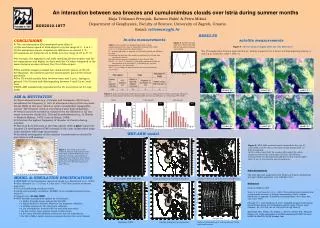
An interaction between sea breezes and cumulonimbus clouds over Istria during summer months. EGU2010-1877. RESULTS. In-situ measurements. satelite measurements. CONCLUSIONS The cumulonimbus (Cb) developed more often if:

E N D
An interaction between sea breezes and cumulonimbus clouds over Istria during summer months EGU2010-1877 RESULTS In-situ measurements satelite measurements • CONCLUSIONS • The cumulonimbus (Cb) developed more often if: (1) the sea breeze speed at Pula-airport is in the range of 3 - 5 m s-1, (2) the maximum sea-air temperature difference is around 4 °C, (3) maximum air temperature in Pazin is in the range of 25 to 31 °C. • In average, the nighttime and early morning LB was weaker and the air temperature was higher on days with the Cb when compared to the same features on days without the Cb at Pula-airport. • The satellite images revealed two characteristic places of the Cb development: the northern and the southeastern part of the Istrian peninsula. • The Cb would usually form between noon and 2 p.m., lasting in general 3 to 5 hours and disintegrating between 4 and 5 p.m. local time. • WRF-ARF satisfactorily reproduced the Cb occurrence on 23 July 2006 Figure 2. Number of days with Cb in Pazin and with SB in Pula-airport during 1997-2006. • Table 1. The number of analyzed days with surface • measurements from Juneto September during 1997–2006. • SLB day in Pula-airport is chosen when: • during nighttime, a majority of the hourly winds are offshore • or calm; • (II) during the daytime, the winds are onshore for at least four consecutive hours; • (III) diurnal air pressure amplitude is less than 5 hPa; • (IV) ∆T = Ta-Ts>3 °C, where Ta is the daily maximum of the air temperature over land and Ts is the daily sea surface • temperature at 14 h local time. • The Cb day in Pazin is selected when Cb occured between • 10-20 UTC. Figure 4.CB over Istria, 8 August 2006, CH 139, Meteosat 8 The Cb usually form between noon and 2 p.m., lasting in general 3 to 5 hours and disintegrating between 4 and 5 p.m. local time. (CET = UTC+1) Maja Telišman Prtenjak, Karmen Babić & Petra Mikuš Department of Geophysics, Faculty of Science, University of Zagreb, Croatia Email: telisman@gfz.hr 09:00 UTC 10:00 UTC 11:00 UTC Figure 3. Some relationships between maximum 2-m air temperature in Pazin, maximum SB speed and ∆T in Pula-airport between two datasets (SB and Cb) and (SB and no Cb) during 1997–2006. Pazin Pula-airport Pula-airport • AIM & MOTIVATION • Observationalworks (e.g., Prtenjak and Grisogono, 2007) have establishedthe frequency (~ 50% of all summer days) of the sea/land breeze(SLB) in this area, which is underconsiderable topographic control. The frequent result is convergence zone (CZ) along Istria. • Vertical currents initiated or enhanced by the SB front or CZ can cause convective clouds (Cu, Cb) and thunderstorms (e.g., in Florida Pileke & Mahrer, 1978; Yuter & Houze, 1995); • Istria has the highest frequency of thunder in Croatia during summer; • The local duty forecasts at the Pula-airport often a prior report the summer Cb development (TAF forecast) in the calm undisturbed large-scale condition with large uncertainty; • An detail investigation of the summer Cumulonimbus cloud (Cb) over Istria is still missing. 12:00 UTC 13:00 UTC 14:00 UTC WRF-ARW model Figure 5. WRF-ARW modeled results obtained for the case 23 June 2006 at 16:00 UTC in the finest model domain with 1.5 km grid spacing. In the surface wind field, the western SB carried the colder marine air toward the central part of Istria. The SB front enchanced the Cb development (with the vertical velocity higher than 14 m s-1) over eastern part of peninsula. Figure 1. The study area on the northern Adriatic that represents the finest grid in WRF-ARW model. The positions of in-situ meteorological measurements obtained: Pula-airport and Pazin. Topography contours are given for every 300 m between at 0 and 2700 m. Acknowledgements This work has been supported by the Ministry of Science, Educational and Sport (BORA project No. 119-1193086-1311). References Pielke and Mahrer 1978 Yuter, S. E. and Houze Jr., R. A. 1995: Three-dimensional kinematic and microphysical evolution of Florida Cumulonimbus. Part I: Spatial distribution of updrafts, downdrafts and precipitation. Mon. Wea. Rev., 123, 1921-1940. Prtenjak, M. T. and Grisogono, B.,2007: Sea/land breezes climatological characteristics along the northeastern Adriatic coast, Theoret. Appl. Climatol., 90, 201-215, doi:10.1007/s00704-006-0286-9). Skamarock, W.C., Klemp, J.B., Dudhia, J., Gill, D.O., Barker, D.M., Wang, W., Powers,J.G., 2005. A description of the Advanced Research WRF Version 2. NCAR/TN-468+STR, NCAR, Boulder, Colo. • MODEL & SIMULATION SPECIFICATIONS • WRF-ARW 3D nonhydrostatic mesoscale model (e.g. Skamarock et al., 2005); • three domains: ∆x ~ 13.5 km, 4.5 km and 1.5 km (the Lambert conformal projection). • 70 terrain-following coordinate levels. • Initial and boundary conditions: ECMWF at the standard pressure levels every 6 h; • Chosen case: 23 July 2006. • WRF dynamic and physical options for all domains: • a Mellor-Yamada-Janjic scheme for the PBL; • a Rapid Radiative Transfer Model for the longwave radiation; • a Dudhia scheme for the shortwave radiation; • a Lin microphysics scheme with ice and snow processes; • the Eta surface layer scheme based on MO theory • a five-layer thermal diffusion scheme for the soil temperature. • the Betts-Miller-Janjic cumulus parameterization two outer domain 10-m modeled WRF wind field Column integrated cloud hydrometeors Vertical velocity at 3200 m above ground level Maximum CAPE Column integrated precipitation Vertical cross-section of vetical velocity, theta and wind vectors