The Ocean Floor
The Ocean Floor. Mapping the Ocean Floor Continental Margins. Geological Oceanography. Objectives: at the end of the period, you are expected to:. Define what is Oceanography, Value the importance of the ocean, label the features of the ocean floor. Oceanography

The Ocean Floor
E N D
Presentation Transcript
The Ocean Floor • Mapping the Ocean Floor • Continental Margins Geological Oceanography
Objectives:at the end of the period, you are expected to: • Define what is Oceanography, • Value the importance of the ocean, • label the features of the ocean floor.
Oceanography -an interdisciplinary science that draws on the methods and knowledge of geology, chemistry, physics, and biology to study all aspects of the world ocean. Geological Oceanography
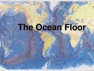
Geography of the ocean The area of the Earth is 510 M km2. Of this total, approximately 360 M km2is represented by oceans and marginal seas. Geological Oceanography
Marginal seas are the seas around the ocean’s margin Geological Oceanography
Northern Hemisphere(land sphere) • 61% water • 39% land Geological Oceanography
Southern Hemisphere(water sphere) • 81% water • 19% land Geological Oceanography
Oceans of the World • Pacific Ocean • Atlantic Ocean • Indian Ocean • Southern Ocean • Arctic Ocean Geological Oceanography
Pacific Ocean covers more than 166 million square kilometers about 1/3 of the Earth surface Geological Oceanography
Atlantic Ocean covers an area of 82 million sq km Geological Oceanography
Indian Ocean covers an area of about 73 million sq km Geological Oceanography
Southern Ocean large circumpolar body of water totally encircling the continent of Antarctica Geological Oceanography
Arctic Ocean the smallest ocean - more than five times smaller than the Indian and Atlantic oceans Geological Oceanography
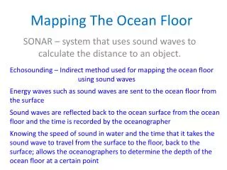
Bathymetry - is the measurement of ocean depths and the charting of the shape or topography of the ocean floor. Techniques in bathymetry: • SONAR (Sound Navigation and Ranging) or echo sounder • Multi-beam SONAR • Satellite altimetry Geological Oceanography
Echo sounding is a method of measuring depth using powerful sound pulses. The time it takes for the sound pulse to travel to the sea bed and bounce back is a measure of the depth. Geological Oceanography
The speed of sound in water is 1500 m/s. Thus, depth of any part of an ocean is given by: d= ½ (1500 m/s X echo travel time) Geological Oceanography
Multibeam systems can provide more accurate measurements than echo sounders. Multibeam systems collect data from as many as 121 beams to measure the contours of the ocean floor. Geological Oceanography
Satellite altimetry is an indirect way of measuring depth and detecting sea floor features. Satellites measure the sea surface height from their orbits by bouncing rapid pulses of radar energy off the ocean surface. Geological Oceanography
This extra mass pulls the sea surface into gentle “hills” above the features. Thus we can “see” features below the surface by measuring the variations in sea surface height that these features cause! Geological Oceanography
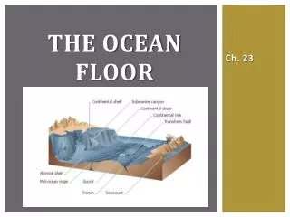
The Ocean Floor Three Major Provinces Continental margin Ocean basin floor Mid-ocean ridge Geological Oceanography
Continental Margin Passive Continental Margin Active Continental Margin • Continental shelf • Continental slope • Continental rise Geological Oceanography
Continental Margin is the transition to the deep ocean basin. The margin belongs mostly to the continent. Geological Oceanography
Continental Margins 1. Passive margins (Atlantic-type margins) face the edges of diverging tectonic plates. Because there is no collision or subduction taking place, tectonic activity is minimal and the Earth's weathering and erosional processes are winning. Geological Oceanography
CONTINENTAL SHELF - the shallowest portion of the margin and the portion nearest to the continent. This feature is simply an underwater extension of the adjacent above-water portion of the continent, the COASTAL PLAIN. Geological Oceanography
CONTINENTAL SLOPE- is the sloping edge of the continent as it merges into the deep ocean basin. Geological Oceanography
Submarine Canyons known as deep, steep-side valleys. Geological Oceanography
Turbidity Currents Turbidity currents are periodic down slope movements of dense, sediment-laden water. Geological Oceanography
CONTINENTAL RISE- is a wedge of sediment that has accumulated at the base of the slope due to the change in gradient from the steeper slope to the virtually flat abyssal plain. Geological Oceanography
Passive Continental Margin Geological Oceanography
Continental Margins 2. Active margins (Pacific-type margins) are located near the edges of converging plates, where one plate dives beneath another at an oceanic trench, in the process of subduction. Active margins are therefore sites of extensive volcanic and earthquake activity. Geological Oceanography