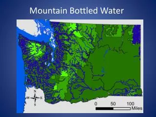
Mountain Bottled Water
Crystal Mountain Bottled Water Company has enlisted STUD GIS INC. to locate a new fresh water source. The analysis will ensure the selected water source meets strict criteria established by the Department of Ecology, including water quality standards, geographic location, and accessibility. Key requirements include being twenty miles from any population center, within fifteen miles of an airport, and five miles from any fish hatchery, all while being situated in a forested area, preferably west of the Cascade Mountain Range, and near a major highway.

Mountain Bottled Water
E N D
Presentation Transcript
Intro Crystal Mountain Bottled Water Company has requested assistance in locating the geographic position of their new fresh water source. STUD GIS INC. has been contracted to conduct a GIS analysis to determine the location of this new water supply.
Scope • The water source selected shall conform to the following criteria: • The water quality of the stream or river selected must meet standards set by Category 1 as defined by the Department of Ecology (See Appendix for Category description and reference). • The water source shall be located in a forested area. • The water source cannot be from a National Park • The water source shall be at least twenty miles from the nearest population center. • The water source shall be within 15 miles of the nearest airport. • The water source shall be at least five miles from a fish hatchery. • The water source would be preferred to be located on the west side of the Cascade Mountain Range. • The water source shall be within 5 miles of a major highway.
Mapped locations of Toxins in Water Systems Toxin Locations 1mile Toxin Buffer After
Removal all Streams from outside Forests and in National Parks Before After
Removal of Streams from inside 10 mile Populated areas Populated Areas 10 Mile Buffer After
Streams within 15 miles of Airports Location of Airports 15 Mile Buffer After
Removal of Streams within 5 miles of a Hatchery Location of Hatcheries 5 Mile Buffer After
Place Selected North Fork Calawah River
Bibliography Ecology, D. o. (n.d.). Geographic Information Systems GIS. Retrieved December 1, 2009, from Department of Ecology: http://www.ecy.wa.gov/services/gis/data/data.htm Ecology, W. S. (n.d.). Water Quality Assessment Categories. Retrieved December 8, 2009, from Washington State Department of Ecology: http://www.ecy.wa.gov/programs/wq/303d/WQAssessmentCats.html SteamNet Fish Data for the NorthWest. (2009, February). Retrieved December 8, 2009, from All Fish Species GIS Data: http://www.streamnet.org/mapping_apps.html WSDOT. (n.d.). WSDOT GeoDataDistrubution Catalog. Retrieved December 1, 2009, from Washington Sate Department of Transportation: http://www.wsdot.wa.gov/mapsdata/geodatacatalog/default.htm
Michael Beatty Chris Hagen Jeff Tollar Mountain Bottled Water Example of River Tool Washington State Waterways Washington State Populated Areas Intro Crystal Mountain Bottled Water Company has requested assistance in locating the geographic position of their new fresh water source. STUD GIS INC. has been contracted to conduct a GIS analysis to determine the location of this new water supply. • Scope • The water source selected shall conform to the following criteria: • The water quality of the stream or river selected must meet standards set by Category 1 as defined by the Department of Ecology (See Appendix for Category description and reference). • The water source shall be located in a forested area. • The water source cannot be from a National Park • The water source shall be at least twenty miles from the nearest population center. • The water source shall be within 15 miles of the nearest airport. • The water source shall be at least five miles from a fish hatchery. • The water source would be preferred to be located on the west side of the Cascade Mountain Range. • The water source shall be within 5 miles of a major highway. Elimination by 10 mile Buffer Location North Fork Calawah River Result from Buffer Analysis River Tool Flow Analysis Bibliography Ecology, D. o. (n.d.). Geographic Information Systems GIS. Retrieved December 1, 2009, from Department of Ecology: http://www.ecy.wa.gov/services/gis/data/data.htm Ecology, W. S. (n.d.). Water Quality Assessment Categories. Retrieved December 8, 2009, from Washington State Department of Ecology: http://www.ecy.wa.gov/programs/wq/303d/WQAssessmentCats.html SteamNetFish Data for the NorthWest. (2009, February). Retrieved December 8, 2009, from All Fish Species GIS Data: http://www.streamnet.org/mapping_apps.html WSDOT. (n.d.). WSDOT GeoDataDistrubution Catalog. Retrieved December 1, 2009, from Washington Sate Department of Transportation: http://www.wsdot.wa.gov/mapsdata/geodatacatalog/default.htm • The Creation of our water Tool Provided us with: • Easy changing of parameters • The ability to apply it to any state