Download

1 / 18
180 likes | 393 Vues
Drought Information Needs for Water Resources Management: Texas as a Case Study. Bridget R. Scanlon, Rong Fu, Todd Caldwell, Di Long, and Nelun Fernando Jackson School of Geosciences, Univ. of Texas at Austin. Outline. Background on aquifers Drought information needs (ET, SM, GW)

E N D
Drought Information Needs for Water Resources Management: Texas as a Case Study Bridget R. Scanlon, Rong Fu, Todd Caldwell, Di Long, and Nelun Fernando Jackson School of Geosciences, Univ. of Texas at Austin
Outline • Background on aquifers • Drought information needs (ET, SM, GW) • Modeling and satellite products • Example: 2011 drought in Texas
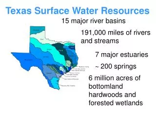
Storativity: amount of water released from an aquifer for a decrease in water level. Unconfined aquifers 1 – 30% of water storage can be recovered Confined aquifers 0.005 – 0.5% of water in storage can be recovered
Typical Dipping Confined Aquifer Same aquifer: unconfined and confined
Gulf Coast Aquifer SystemPre-Development Springflow and baseflow Recharge
Gulf Coast Aquifer SystemPost Development Recharge Recharge Pumping
Implications for Using Model and Satellite Data • Ogallala Aquifer: demand driven system, not really impacted directly by changes in recharge but indirectly affected by pumpage • Confined aquifers: disconnected from surface water, recharged thousands of years ago, only impacted by drought indirectly through pumpage
Information Needs • Groundwater planning time horizon: 50 yr, 2010 – 2060 • Based on 1950s drought • National drought maps and archives with time series are very valuable, extend back to 1900? • Climate in next 50 yr: 1 yr extreme droughts? Longer term droughts? • How well can we predict beginning of droughts? Persistence?, end of droughts? • Seasonal drought predictions: fall – early spring: water transfers if drought predicted • Not irrigate if predict intense drought? • Daily temperature data for electricity sector
Data Needs • Evapotranspiration (MODIS, Landsat, NLDAS): • Irrigation needs • Soil moisture storage (SMAP, NLDAS): • Irrigation needs • Drought persistence…feedback • Precipitation requirements for reservoir recovery • Flood predictions
Data Needs • Groundwater (NLDAS, GRACE) • Recharge (NLDAS): P − ET = Recharge 500 ± 50 − 480 ± 48 = 20 ± 98 • GRACE: ∆TWS = ∆ SMS + ∆ GWS Water Scarcity = Demand > Supply
Satellite and Modeling Products • Satellite ET, GRACE derived ET, and LSM ET • Satellite ET unconstrained by water balance (1 km resolution) • Model ET more reliable, coarse ( 14 km resolution) • GRACE GW, LSM GW • Difficult to disaggregate GRACE TWS into components with large variability in LSM SMS • LSM provide upper BC for groundwater (unconfined aquifers)
PDSI and GRACE Total Water Storage Long et al., 2013
Summary • Information needs for drought: • Long-term planning, 1 yr versus multiyear droughts? • Seasonal forecasting: 6 – 9 months • Daily data: temperature, heat waves • Archive data back to 1900 • Satellite data: ET, irrigation demand; soil moisture • Modeling: upper boundary condition for unconfined aquifers