Download
1 / 37
370 likes | 494 Vues
Deterministic and Empirical Assessment of Smoke’s Contribution to Ozone (DEASCO 3 ) Project WESTAR-EPA Wildfire and Ozone Exceptional Events Meeting Tom Moore March 5, 2013 - Sacramento. 3-year Average 4 th Highest 8-Hour Ozone value by County 2008-2010.

E N D
Deterministic and Empirical Assessment of Smoke’s Contribution to Ozone (DEASCO3) ProjectWESTAR-EPA Wildfire and Ozone Exceptional Events MeetingTom MooreMarch 5, 2013 - Sacramento
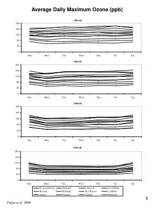
3-year Average 4th Highest 8-Hour Ozone value by County 2008-2010 AQS Federal Reference Method data from the monitoring site in each County with the highest Ozone values
3-year Average 4th Highest 8-Hour Ozone value for Rural/Class I Sites 2008-2010 AQS Federal Reference Method data from rural or Class I area monitoring sites
Overview • Develop and apply (our) improved understanding of Fire/Smoke’s impact on elevated Ozone episodes • Assist FLMs in future Ozone air quality planning • For Exceptional Event demonstration packages • FLM future fire “activity planning / scoping” • In SIP process • Provide tools, rules, and examples for use by FLMs, states, EPA, and others • DEASCO3 project • Technical elements • Deliverables • Companion study started late 2012: • Prescribed and Other Fire Emissions: Particulate Matter Deterministic & Empirical Tagging & Assessment of Impacts on Levels (PMDETAIL) • Funding for both from FLM Joint Fire Sciences Program
Western ozone and PM precursors - key emissions sources • Power plants decreasing markedly • Mobile sources controlled and emission rates decreasing markedly through federal rules and state testing programs • Fire activity and effects are huge (largest air pollution source in the West), receiving intensive study • Deterministic & Empirical Assessment of Smoke’s Contribution to Ozone (DEASCO3) • Prescribed and Other Fire Emissions: Particulate Matter Deterministic & Empirical Tagging & Assessment of Impacts on Levels (PMDETAIL) • many others…. • Biogenics (natural plant sources) • Oil and gas……….. • All sources currently being studied in comprehensive regional modeling analysis • 2008 base year • West-wide Jumpstart Air Quality Modeling Study (WestJumpAQMS)
DEASCO3 project - purpose & goals • Assess fire’s impact on elevated ozone episodes with retrospective studies from the West to the Southeastern U.S., using empirical and photochemical modeling analyses • DEASCO3 is initial study of fire and ozone 2002 through 2008, then adds PM for 2002-13 and ozone for 2009-13 in PMDETAIL • Outcomes • Support future collaborative FLM-state ozone air quality planning • Develop “lessons learned”, basic analysis rules for fire-ozone episodes, and online tools for FLM-state air quality planning • Through the WRAP Fire Emissions Tracking System (FETS), prepare and implement planning-grade fire emissions inventories in the FETS suitable for SIP work by states and FLMs • Publish data and analysis results in transparent and reproducible formats
Deterministic and Empirical Assessment of Smoke’s Contribution to Ozone (DEASCO3) Project • Analytical results and technical tools for FLMs to participate more fully in ozone air quality planning efforts • Complex technical analyses of well-chosen historic events (Case Studies) • Web-accessible tables, charts, and maps that describe how and to what extent fires contribute to ambient ozone concentrations • 2008 national emission inventory development for wildland and crop residue fires • Apply existing 2002 fire EI data • Photochemical Grid Modeling (PGM) with source apportionment and empirical analyses to better assess fire’s contribution to ozone • Accessible online tool for FLMs to access results and technical products • Collaborative review and analysis by NPS and USFS air program staff • Integrate FLMs’ technical and policy needs and perspectives into the technical products • Essential documentation and summary reports of methods and results • DEASCO3 (project 1 of 2) complete June 2013
DEASCO3 Hypotheses Technical Ho1 – Smoke from fire contributes to background concentrations of O3 in large areas of the U.S. Ho2 – Fire/Smoke management can affect formation of O3. Ho3 – Fire(s) cause/contribute to O3 exceedances. Policy Ho4 – Better quantitative information will help FLMs to assess the use of smoke management techniques to address nonattainment issues. Ho5 – The Rank Order(s) in the Online Tool will help FLMs to be more effective in the air quality planning processes.
Activity Data distribute emissions Loading Moisture DEASCO3 FETS Chemical Profiles Loft emissions Emissions Model
Gnarl Ridge Fire Oregon • Ignited in August 2008 • Lull in burning activity of several weeks • Common wildfire size range (3,000 acres) • NEIv2 method identifies additional burns • matches wildfire acres with MTBS • All wildfire burning in August • DEASCO3 method attributes all HMS data to wildfire • Misses some burn days • distributes acres across Aug-Sep http://www.wrapfets.org/pdf/deasco3/NEIC_tampa_mavko-moore_FINAL-REVISED.PDF
Weighted Emissions Potential – example empirical analysis tool • WEP analysis was designed as a screening tool for states, similar to but less rigorous than the PGM source apportionment methods • Does not explicitly account for chemistry and removal processes • Integrates gridded emissions data, meteorological back trajectory residence time data, a one-over-distance factor to approximate deposition, and a normalization of the final results = X Emissions Residence Times Weighted Emissions
Mass source apportionment by source category and region • Species mass for various time periods – directly comparable to monitoring data Example CAMx PGM Source Apportionment
Grey lines depict HYSPLIT back- and forward-trajectories from an ozone monitor in southern Oregon and the Biscuit fire MTBS fire perimeters for fires that started in July 2002 are shown in grey Prototype Results Display for Online Tool Ozone concentrations listed include the modeled contribution from fire (OSAT), total modeled layer1 ozone, and observed ozone at monitor locations.
Leveraging Improved AQ Planning WestJump AQMS DEASCO3 Except. Event applications PMDETAIL 2008 and 2011 NEIv2 (USFS collaboration)
Regional Photochemical Grid Modeling with Ozone, PM2.5 and Visibility Source Apportionment for the Western U.S.
WestJumpAQMS • West-wide Jump-start Air Quality Modeling Study (WestJumpAQMS) objectives: • Initiate the next generation ozone and PM2.5 modeling for the western U.S. • Develop modeling platform that can be used for transport, NAAQS and NEPA analysis • Further a concept initiated by NMED, EPA R6, BLM, BP and WRAP • Continue approach developed and work performed by WRAP Regional Modeling Center (RMC)
Overview of WestJumpAQMS Modeling Approach • 2008 calendar year • WRF meteorological model • 2008 NEIv2.0 emissions with augmentations • SMOKE emissions model • WRAP updated MEGAN v2.10 for biogenics • MOVES for on-road mobile sources • CAMx and CMAQ photochemical grid models • Ozone and PM Source Apportionment modeling to begin to analyze transport issues
36/12/4 km WRF/SMOKE Domains • 36 km CONUS Domain • 12 km WESTUS Domain • 4 km Inter-Mountain West Processing Domain (IMWPD) • WRF meteorological and SMOKE emissions model run for the entire 4 km IMWPD • Photochemical Grid Model (PGM) applied to smaller 4 km domains for source apportionment (window)
2008 SMOKE Emission Categories • Continuous Emissions Monitor (CEM) Points • Non-CEM Points (2008 NEIv2.0) • Area and Non-Road (2008 NEIv2.0) • MOVES for on-road mobile sources • Oil and Gas WRAP Phase III projected to 2008 • Includes new Permian Basin (NM/TX) • Fire Inventory from NCAR (FINN) • Updated with DEASCO3 and PMDETAIL JSFP fire inventories • WRAP Windblown Dust Model • Lightning and Sea Salt • MOZART boundary conditions
Model Performance Evaluation (MPE) • Initial 36/12 km CAMx & CMAQ Runs • Refined 36/12/4 km CAMx Runs • Evaluation Databases: • AQS: hourly gas-phase ozone, NO2, CO etc. • FRM: 24-hour total PM2.5 mass • CSN: 24-hour speciated PM2.5 • IMPROVE: 24-hour speciated PM2.5 • CASTNet: weekly speciated PM2.5 and hourly ozone • NADP: weekly sulfate and nitrate wet deposition • Ozonesonde: intermittent vertical ozone soundings
FRM Network FRM CSN IMPROVE CASTNet
CAMx Source Apportionment Modeling • APCA version of Ozone Source Apportionment Technology (OSAT) • Particulate Source Apportionment Technology (PSAT) • Sulfate (SO4) • Nitrate (NO3) and Ammonium (NH4) • Primary PM (EC, OA, OPM2.5) • Two Rounds of Source Apportionment Modeling
Level 1 APCA Ozone Source Apportionment • CAMx 36/12 km – Ozone Season • Western State Source Regions • 2 Source Categories • Anthropogenic • Natural
Initial Source Apportionment Modeling • Level 1 APCA Ozone: State Regions by Anthro-Natural • Described Previously • Level 2 OSAT Ozone: One Source Region and Anthro-Natural • Examine VOC-limited vs. NOX-limited O3 Formation • Level 3 PSAT PM: State Regions/Anthro-Natural • Like Level 1 only for PM (SO4, NO3/NH4 & Primary) • Preliminary Results and Detailed Source Apportionment Modeling Plan • 2nd round of additional apportionment with more source categories and/or sub-state spatial regions possible
On-Line Source Apportionment Visualization Tool • Source Apportionment modeling produces lots of information • Extract key information at sites and developed on-line visualization tool • AQS, IMPROVE, etc. • Allow users to drill down into Source Apportionment results for sites and sources of interest • CENRAP Visualization Tool for Regional Haze planning • CAMx PSAT 36 km CONUS • State-specific PM • 2002 / 18 Visibility impacts at Class I areas • Example – Rocky Mountain National Park
Example non-WestJumpAQMS work - 2018 Worst 20% Days at Rocky Mountain National Park Source Categories by Species
Example non-WestJumpAQMS work - 2018 Worst 20% Days at Rocky Mountain National Park Species by Source Categories
Example non-WestJumpAQMS work - 2018 Worst 20% Days at Rocky Mountain National Park Ranked Contributions by Source Region and Category
WestJumpAQMS Schedule • 8-month delay getting started waiting for 2008 NEIV2.0 • Products - WRAP webpage: • http://www.wrapair2.org/WestJumpAQMS.aspx • Modeling Plan – 1/23/12 • WRF Evaluation Report • 2/29/12 • 13 Emissions Memos • Various Stages, complete March 2013 • Emissions modeling complete early October 2012 • Draft Modeling & Source Apportionment Protocol • Review and comment complete in February 2013 • 2008 Base Case Modeling • complete early 2013 • Source Apportionment Rounds 1 and 2 • March / April 2013 • Final Report • May / June 2013