Download
1 / 1
10 likes | 99 Vues
Explore methane consumption rates and sink capacity in Italian soils using GIS modeling. Study covers agricultural and natural soil types, highlighting key factors influencing methane uptake.

E N D
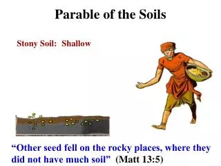
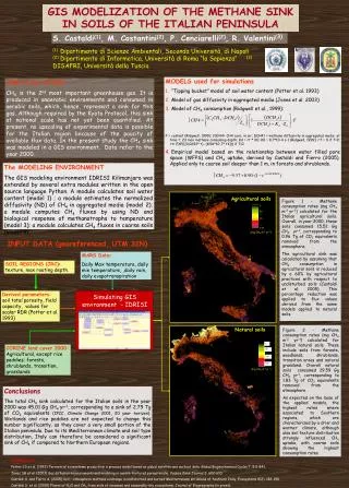
0 30 70 115 (mg CH4 m-2 yr-1) 0 50 100 150 GIS MODELIZATION OF THE METHANE SINK IN SOILS OF THE ITALIAN PENINSULA S. Castaldi(1), M. Costantini(2), P. Cenciarelli(2), R. Valentini(3) (1) Dipartimento di Scienze Ambientali, Seconda Università, di Napoli (2) Dipartimento di Informatica, Università di Roma “la Sapienza” (3) DISAFRI, Università della Tuscia • MODELS used for simulations • “Tipping bucket” model of soil water content (Potter et al. 1993) • Model of gas diffusivity in aggregated media (Jones et al. 2003) • Model of CH4 consumption (Ridgwell et al., 1999): • F = costant (Ridgwell, 1999); C0CH4= CH4 conc. in air; DCH4t = methane diffusivity in aggregated media at time t; Zd max methane consuming depth; Kd = rt * K0; K0 = 8.7*10-4 s-1 (Ridgwell, 1999); rT = 0 if T<0; rt= EXP(((0.0693* t)- (8.56*10-7* t4))) if T>0 • Empirical model based on the relationship between water filled pore space (WFPS) and CH4 uptake, derived by Castaldi and Fierro (2005). Applied only to coarse soil deeper than 1 m, in forests and shrublands. AIM of the STUDY CH4 is the 2nd most important greenhouse gas. It is produced in anaerobic environments and consumed in aerobic soils, which, hence, represent a sink for this gas. Although required by the Kyoto Protocol, this sink at national scale has not yet been quantified. At present, no upscaling of experimental data is possible for the Italian region because of the paucity of available flux data. In the present study the CH4 sink was modeled in a GIS environment. Data refer to the year 2000. The MODELING ENVIRONMENT The GIS modeling environment IDRISI Kilimanjaro was extended by several extra modules written in the open source language Python. A module calculates soil water content (model 1) ; a module estimates the normalized diffusivity (ND) of CH4 in aggregated media (model 2); a module computes CH4 fluxes by using ND and biological response of methanotrophs to temperature (model 3); a module calculates CH4 fluxes in coarse soils (model 4). Agricultural soils Figure 1 - Methane consumption rates (mg CH4 m-2 yr-1) calculated for the Italian agricultural soils. Overall, in year 2000, these soils consumed 15.52 Gg CH4 yr-1, corresponding to 0.96 Tg of CO2 equivalents removed from the atmosphere. The agricultural sink was calculated by assuming that CH4 consumption in agricultural soils is reduced by a 60% by agricultural practices with respect to undisturbed soils (Castaldi et al. 2005). This percentage reduction was applied to flux values derived from the same models applied to natural soils. INPUT DATA (georeferenced, UTM 32N) MARS Data: Daily Max temperature, daily min temperature, ,daily rain, daily evapotranspiration SOIL REGIONS (JRC): texture, max rooting depth. Derived parameters:soil total porosity, field capacity, values for scalar RDR (Potter et al. 1993) Simulating GIS environment - IDRISI Natural soils Figure 2 - Methane consumption rates (mg CH4 m-2 yr-1) calculated for Italian natural soils. These include soils from forests, woodlands, shrublands, transition areas and natural grassland. Overall natural soils consumed 29.59 Gg CH4 yr-1, corresponding to 1.83 Tg of CO2 equivalents removed from the atmosphere. As expected on the base of the applied models, the highest rates where associated to Southern regions, which are characterized by a drier and warmer climate, although also soil texture distribution strongly influenced CH4 uptake, with coarse soils showing the highest consumption rates. CORINE land cover 2000: Agricultural, except rice paddies; forests, shrublands, transition, grasslands (mg CH4 m-2 yr-1) Conclusions The total CH4 sink calculated for the Italian soils in the year 2000 was 45.01 Gg CH4 yr-1, corresponding to a sink of 2.79 Tg of CO2 equivalents (IPCC, Climate Change 2001, 20 year horizon). Wetlands and rice paddies are not expected to change this number significantly, as they cover a very small portion of the Italian peninsula. Due to its Mediterranean climate and soil type distribution, Italy can therefore be considered a significant sink of CH4 if compared to Northern European regions. REFERENCES Potter CS et al. (1993) Terrestrial ecosystems production: a process model based on global satellite and surface data. Global Biogeochemical Cycles 7: 811-841. Jones SB et al. (2003) Gas diffusion measurements and modeling in coarse-textured porous media. Vadose Zone Journal 2: 602-610. Castaldi S. and Fierro A. (2005) Soil – atmosphere methane exchange in undisturbed and burned Mediterranean shrubland of Southern Italy. Ecosystems 8(2): 182-190. Castaldi S. et al. (2005) Fluxes of N2O and CH4 from soils of savannas and seasonally-dry ecosystems. Journal of Biogeography (in press).