Search Patterns
Search Patterns. Boat Forces Center Coxswain “C” School. Search Patterns -- Rev: Nov 05. Objectives. Given the following instruction state common terms used in Search and Rescue Given basic navigation tools plot and execute both precision and drifting patterns. References.

Search Patterns
E N D
Presentation Transcript
Search Patterns Boat Forces Center Coxswain “C” School Search Patterns -- Rev: Nov 05
Objectives • Given the following instruction state common terms used in Search and Rescue • Given basic navigation tools plot and execute both precision and drifting patterns
References • National Search and Rescue Manual Vol I & II COMDINST M16120.5 series • U.S. Coast Guard Addendum to the National Search and Rescue Supplement COMDINST M16130.2 series • Boat Crew Seamanship manual COMDINST M16114.5 series • CG Boat Operations and Training Manual VOL I & II COMDINST M 16114.32 series
Value • The boat Coxswain must be able to execute the search pattern correctly, so that lives and property in distress have the best possible chance for survival
Coxswain Responsibility • Keep crew alert and attentive • Execute the search pattern correctly • SOMEONE'S LIFE MAY DEPEND ON IT
Search Planning • Is necessary when the location of a distress object is not known, or time has passed since the objects position was last known
SAR Planning • Where does SAR planning come from? • The Coast Guard Addendum to the National Search and Rescue Supplement COMDTINST M16130.2(series)
SAR Addendum • The primary search planning & rescue operations guidance and policy manual
Pattern Nomenclature • Datum • The most probable location of a search • object corrected for movement over time
Pattern Nomenclature • Explanation of movement: • To locate datum, Two major forces need to • be considered: • Total Water Current • Leeway
Pattern Nomenclature • Total water current (TWC) • The sum of all water currents that might be acting upon a search object in any given locality Sea Current Wind Current Reversing Tidal Current River Current Lake Current Surf & Rip Current The best information on TWC is obtained from a Datum Marker Buoy.
Pattern Nomenclature • Leeway: • The movement through the water caused by winds blowing against the exposed surfaces of the search object. The more exposed area the object has the greater the wind force on the object
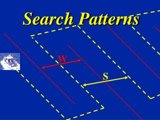
Pattern Nomenclature • Search Leg: • The track line of the SRU involved in a search pattern, or the long leg along the track of a parallel or creeping line search
Pattern Nomenclature • Cross Leg: • The connection between search legs of a parallel or creeping line search pattern
Pattern Nomenclature • Sweep Width: • The corrected distance a SRU should be able to visually detect the search object on either side of the search leg
Pattern Nomenclature • Track Spacing: • The distance between adjacent parallel legs • With the exception of the Sector search which will have a radius
Pattern Nomenclature • Major Axis: • A bearing line used for the orientation of a rectangular search area from the center
Pattern Nomenclature • Minor Axis: • A bearing line perpendicular to the major axis
Pattern Nomenclature • Commence Search Point (CSP) • The location in the search area that the SRU starts the search pattern
Pattern Nomenclature • Initial Response (PIW) • When searching for people in the water start a Sector Search ASAP: • Speed 6 knots • Track spacing: .1 NM • 1 minute search legs
Pattern Nomenclature • Search Area: • The area most likely to contain the search object. • Start with determining datum • There are 7 different methods
Corner Method BLDG ABAND LT HOU Point Comfort 37º20’26”N 076º13’57”W Corner Method: In this method the latitude and longitude (or geographic features) of each corner of the search area are given 37º19’00”N 076º15’00”W 37º19’36”N 076º12’05”W 37º18’17”N 076º13’19”W
Track line Method BLDG ABAND LT HOU Point Comfort 37º21’45”N 076º14’22”W Trackline Method: The latitude and longitude of the departure point, turns and destination are given with a specific width along the track 37º20’44”N 076º12’06”W 37º18’35”N 076º12’15”W
Center Point Circular BLDG ABAND LT HOU Point Comfort Center Point, Circular Area:The latitude and longitude of the center point are given with a radius 37º21’00”N 076º13’38”W 0.75 NMradius
Center Point BLDG ABAND LT HOU Point Comfort 37º21’00”N 076º13’38”W Center Point, Rectangular or Square Area:The latitude and longitude of the center point are given with the direction of the major axis and the length and width of the area
Range and Bearing BLDG ABAND LT HOU Point Comfort 140ºT2 NM Range and Bearing to Center Point:The center point may also be designated bya range and bearing from a geographic landmark
Landmark Boundary 3 NM BLDG Landmark Boundary:Two or more landmarks are given asboundaries of the search area along a shoreline Point Comfort
Lat/Long Boundary BLDG ABAND LT HOU Point Comfort 37º21’00”N 076º14’30”W 076º11’30”W Latitude/Longitude Boundary:The sides of the search area are oriented North-Southand East-West and the latitude and longitude of thesides are given 37º18’00”N
Pattern Designations • First Letter Designates Pattern: • “P” for Parallel • “C” for Creeping Line • “S” for Square • “V” for Sector • “T” for Track line • “B” for Barrier
Pattern Designations • Second Letter Designates Number of SRU’s: • “S” for Single Search Unit • “M” for Multiple Search Units • Third Letter for Supplementary Information: • “R” for Radar Coordination or Return • “N” for Non-Return to Starting Point
Labeling Patterns • Plotted in true • Courses labeled in true and compass • Turns labeled with DR’s and DR times
“PS” Pattern • Parallel track search, Single unit use: • Large area • Position of search object approximate • Uniform coverage desired • Search leg parallel to major axis
Plotting a “PS” 1 ½ 0 1 2 3 4 • Determine Search Area Search Area N (True)
Plotting a “PS” 1 ½ 0 1 2 3 4 Search Area Measure ½ track spacing in from the corners
Plotting a “PS” 1 ½ 0 1 2 3 4 Connect the marks to make the patterns size
Plotting a “PS” 1 ½ 0 1 2 3 4 Mark CSP, mark full track spacing and lay out cross legs CSP
Plotting a “PS” 1 ½ 0 1 2 3 4 • Lay out search legs, and erase every other cross leg CSP
Plotting a “PS” 1 ½ 0 1 2 3 4 C- ºT/ ºC D- NM C- ºT ºC D- NM C- ºT/ ºC D- NM S- KN CSP Label a minimum of three legs a DR at all turns
“CS” Pattern • CREEPING LINE SEARCH, SINGLE UNIT • USE: • LARGE AREA • UNIFORM COVERAGE DESIRED • POSITION OF SEARCH OBJECT IS BELIEVED TO BE ON ONE END OF SEARCH AREA • SEARCH LEGS PARALLEL TO MINOR AXIS
Plotting a “CS” 1 ½ 0 1 2 3 4 Search Area N (True)
Plotting a “CS” 1 ½ 0 1 2 3 4 Measure ½ track spacing in from the corners Search Area N (True)
Plotting a “CS” 1 ½ 0 1 2 3 4 Connect the marks to make the pattern size
Plotting a “CS” 1 ½ 0 1 2 3 4 Mark CSP, measure full track spacing and lay out cross legs CSP
Plotting a “CS” 1 ½ 0 1 2 3 4 Lay out search legs and erase every other cross leg CSP
Plotting a “CS” 1 ½ 0 1 2 3 4 C- ºT/ ºC D- NM C- ºT ºC D- NM C- ºT/ ºC D- NM S- KN • Label a minimum of three legs and a DR at all turns CSP
“VS” Pattern • SECTOR SEARCH, SINGLE UNIT USE: • RELIABLE POSITION OF SEARCH OBJECT • CONCENTRATED AT DATUM • DATUM AT CENTER • STARTS AND ENDS AT DATUM • ALL TURNS ARE 120º TO THE RIGHT • 1ST LEG IN DIRECTION OF DRIFT
Plotting a “VS” Pattern 1 ½ 0 1 2 3 4 • Plot datum and arc a full track spacing around it
Plotting a “VS” Pattern 1 ½ 0 1 2 3 4 Datum • Lay down first track line, either 000 T or the direction of drift originating from datum
Plotting a “VS” Pattern 1 ½ 0 1 2 3 4 Datum • Mark track spacing on either side of the line top and bottom
Plotting a “VS” Pattern 1 ½ 0 1 2 3 4 Datum • Lay out the remaining track lines by connecting the marks