Earth Radiation Budget Observations
220 likes | 394 Vues
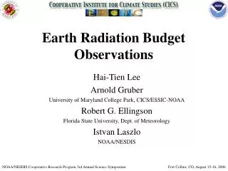
Earth Radiation Budget Observations. Hai-Tien Lee Arnold Gruber University of Maryland College Park, CICS/ESSIC-NOAA Robert G. Ellingson Florida State University, Dept. of Meteorology Istvan Laszlo NOAA/NESDIS. NOAA/NESDIS Cooperative Research Program 3rd Annual Science Symposium.

Earth Radiation Budget Observations
E N D
Presentation Transcript
Earth Radiation BudgetObservations Hai-Tien Lee Arnold Gruber University of Maryland College Park, CICS/ESSIC-NOAA Robert G. Ellingson Florida State University, Dept. of Meteorology Istvan Laszlo NOAA/NESDIS NOAA/NESDIS Cooperative Research Program 3rd Annual Science Symposium Fort Collins, CO, August 15-16, 2006
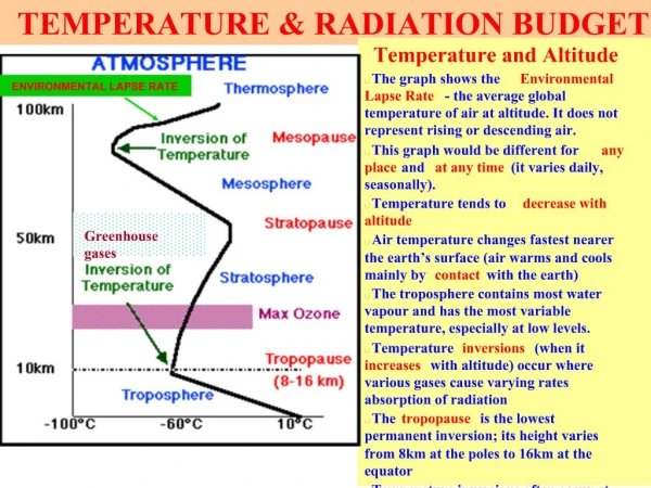
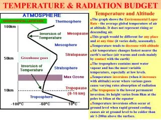
Earth Radiation Budget Kiehl and Trenberth, 1997. Bull. Amer. Meteor. Soc., 78, 197-208.
History • First measurements of OLR as early as 1959 from Explorer-7 • Experiments - ERB, ERBE, ScaRaB, CERES, GERB • First routine measurements of OLR from operational satellites began in 1974 • NOAA scanning radiometer ( SR)- window channel ( 10-12 microns) • Linear algorithm between window radiances and total OLR – based on radiative calculations with model atmospheres • Evolved a few years later to a non linear algorithm which is still in use today - adjusted for different spectral interval • SR data 1974-1978, AVHRR 1979-onward
Tropical AVHRR OLR Anomaly Time/Longitude plot 1984-2003 [5S-5N] Contour level 10Wm-2Pastel yellow are within ±10Wm-2 El Nino
Clear-sky OLR Anomaly (Jan 1998) AVHRR OLR lacks sensitivity to water vapor variation, especially the upper tropo. humidity (UTH).
Multi-spectral HIRS OLR Algorithm Ellingson et al. (1989) ai=regression coefficients =local zenith angle
Regression Model • Channels and spectral intervals – stepwise regression based on 1600 Phillips soundings and radiation transfer model
Validation of Multi-spectral OLR Algorithms Ellingson et al., 1994: Validation of a technique for estimating outgoing longwave radiation from HIRS radiance observations J. Atmos. Ocean. Technol., 11, 357-365. Ba et al., 2003: Validation of a technique for estimating OLR with the GOES sounder. J. Atmos. Ocean. Technol.,20, 79–89. HIRS OLR is Operational since 1998.
AVHRR OLR PC3 and Satellite Observation Time Pingping Xie, 2006 • PC seems related to changes in satellite observations time
Inter-satellite Calibration Collocation: • 1°x1° lat/lon • ±30 minutes Homogeneity filter: • Std error of mean OLR < 1 Wm-2
OLR Climatological Diurnal Model 25 Years of Monthly Mean OLR Local Time Composite Tsaidam Basin Western Pacific
ERBS Non-scanner and HIRS 1985-1999 Tropical 20 NS ERBS NS vs. HIRS Best-fit line slope = 0.998 STD = 0.97 Wm-2r = 0.86 HIRS product is as stable as ERBS-NS.
Tropical Mean OLR 1984-2003 Relative to HIRS Tropical 20 NS HIRS OLR is a reliable and traceable Transfer Standard
HIRS-CERES 2000-2004 Global avg= 1.5 Wm-2 Global= 2.8 Wm-2 Mean diff STD diff Global= 4.0 Wm-2 RMS diff Global RMS Diff = 4.0 Wm-2 * CERES ES4 from Terra-Xtrack Ed.2
Synergy between Operational Polar-Orbiting and Geostationary Satellite OLR Products NOAA/MetOp/NPOESS - HIRS, IASI, CrIS, ERBS/CERES Geostationary FY-2C GERBMet-8/9 GMS Met-5 GOES-W GOES-E MTSAT
Validate HIRS OLR Diurnal Model using GOES Observations Blue: HIRS Red: GOES Nevada Storm track Florida Gulf of Mexico Yucatan Amazon Sierra Madre Occidental 12 6 18 0 Andes Subtropical Oceans GOES and GERB OLR data provide detailed diurnal variation information that we can use it to construct and examine the diurnal models. This figure shows the phase information of the OLR diurnal variation for the GOES-E full disk domain with some typical patterns at selected sites. The HIRS-based diurnal model was compared against that of the GOES, which acts as a reference for error analysis. Nevada