Framework Data Content Base Standard
Framework Data Content Base Standard. Related Topics. NSDI Training Tracks: An initiative to define areas, topics, and materials for training within the NSDI. ISO 19100 Series:

Framework Data Content Base Standard
E N D
Presentation Transcript
Framework Data Content Base Standard Related Topics NSDI Training Tracks: An initiative to define areas, topics, and materials for training within the NSDI. ISO 19100 Series: Suite of standards developed for geographic data and datasets. The most notable is ISO 19135 which pertains to metadata. ANSI Standards: Similar work to ISO, but standards directly apply to data created within the United States. Course Information The National Spatial Data Infrastructure (NSDI) Framework is a collaborative initiative to develop geographic datasets that are compatible based upon spatial location and content. The Framework approach allows data collected for variety of reasons and agencies to work together seamlessly; which can ultimately reduce project costs and increase interagency cooperation. The Framework Data Content Base Standards Suite dictates the requirements for Framework data. This course covers the fundamentals of the Framework Data Content Base Standard which addresses the components which are contiguous throughout each of the Framework Standards. It is designed for users who are both interested in an overview of the Framework Data Content Base Standard as well as designers and developers implementing Framework data, and associated tools. Prerequisites • General Understanding of GIS, Geospatial Data and Metadata • Familiarity with the FGDC and NSDI • Basic knowledge of Geographic Data Standards (specifically ISO 19100 series)
Framework Data Content Base Standard Learning Objectives • Module 1: • Framework Concept • 7 Thematic Elements of Framework • Key Contributors • Practical Uses for Framework • Module 2: • Framework Data Content Standards • Need for Framework Standards • Difference between Framework and data transfer standards • Framework Standards Structure • Module 3: • Purpose of the Framework Base Standard and its importance • How the Base Standard differs from the thematic Framework standards • Who to contact for assistance with the Framework Base Standard • Module 4: • Requirements for Framework conformity • Encoding and Implementation • Specific Modeling and Markup Languages to use Course modules • Understanding Framework • Framework Data Content Standards Suite • Framework Data Content Base Standard • Implementing the Framework Base Standard • Course Review and Comprehensive Self-Test Estimated Time Estimated time for the entire course is 180 minutes.
Course Home FAQ Glossary References Pre-Test Instructions: This pre-test is designed to assess your understanding and knowledge of Framework and the Framework Base Standard before starting this course. Don’t worry about right or wrong answers; make a note of topics you may need to concentrate on as you take this course. Good Luck! Proceed To Framework Pre-Test
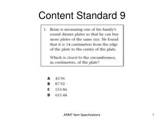
Framework A. a suite of standards designed to address requirements specific to Framework data Framework Standards B. general structure for all GIS data currently in use C. 7 themes of commonly used geospatial data D. common ideas in Framework E. basic requirements of all Framework standards F. an initiative to develop a readily available set of basic geospatial data G. a step-by-step guide to creating Framework data Match the answer from column 2 to the word or phrase in column 1 that it most correctly defines. Column 1 Column 2 Framework Base Standard Framework Themes Answers: Framework – F, Framework Standards – A, Framework Base Standard – E, Framework Themes - C
Course Home FAQ Glossary References Module 1: Understanding Framework Time Requirement Topics • What is Framework • Seven Thematic Components • Why is Framework Important • Framework Organizations • Practical Uses of Framework • Module Exercise and Summary Estimated time for this module is 25 minutes Key Terms Framework Thematic Elements NSDI FGDC Geospatial GIS First Topic What is Framework
Course Home FAQ Glossary References What is Framework • Framework is a set of common themes of geospatial data that provide the basic data "skeleton" needed by users of Geographic Information Systems (GIS). The data layers that make up the Framework are the bones on which state agencies, local and county governments, tribal governments, academic GIS users, and the private sector can build their own GIS data. Framework data layers are intended to be made available to the user community as freely and as easily as possible. • Key aspects of Framework: • Seven themes of most commonly used digital geospatial data • Procedures, technology, and guidelines that provide for integration, sharing, and use of these data. • Institutional relationships and business practices that encourage the maintenance and use of data. • Key benefits of Framework: • Facilitate production and use of geographic data • Reduce overall operating costs for geographic data clients • Improve service and decision-making Quick Facts Although the Framework concept had been discussed since the 1970s, 1996 marked the first year that the FGDC began funding Framework related projects The Bigger Picture The ultimate goal of Framework and the Framework Data Content Standards is to provide uniformity to data and data sources. In doing so data becomes accessible to more users, and reduces cost in data redundancy. next Topic Seven Thematic Elements of Framework
Course Home FAQ Glossary next Topic References Framework Theme: Cadastral Seven Thematic Elements of Framework • Geographic data users from many disciplines have a recurring need for a few themes of basic data: • Cadastral information • Orthoimagery • Elevation • Geodetic control • Hydrography • Governmental units • Transportation • Many organizations produce and use such data every day. These themes comprise the core geospatial data used by most Geographic Information Systems (GIS) applications. Essentially, the NSDI seeks to assemble this basic geospatial data nationwide and the Framework is the foundation for this effort.
Course Home FAQ Glossary next Topic References Framework Theme: Digital Orthoimagery Framework Theme - Cadastral Cadastral data describes the geographic extent of past, current, and future right, title, and interest in real property, including above, surface, and below ground and water, and the foundation to support the description of that geographic extent. Cadastral information can include reference systems such as the Public Land Survey System (PLSS) and similar systems for areas not covered by the PLSS (for example, the Connecticut Western Reserve in Ohio). It also includes publicly administered parcels, such as military reservations, national forests, and state parks, as well as marine jurisdictions. The Framework also provides a means to link existing parcel data into the larger cadastral network.
Course Home FAQ Glossary next Topic References Framework Theme: Elevation Framework Theme - Digital Orthoimagery Digital orthoimagery is georeferenced images of the Earth's surface, collected by a sensor in which image object displacement has been removed for sensor distortions and orientation and for terrain relief. Many geographic features, including those that are part of the Framework, can be interpreted and compiled from an orthoimage. Orthoimages can also serve as a backdrop to reference the results of an application to the landscape. The Framework may include imagery that varies in resolution from sub meter to tens of meters. Accurately positioned, high-resolution data (pixels of 1 meter or finer) are presumed to be the most useful for supporting the compilation of Framework features, particularly those that support local data needs.
Course Home FAQ Glossary next Topic References Framework Theme: Geodetic Control Framework Theme - Elevation Elevation data provides information about terrain. Elevation refers to a spatially referenced vertical position above or below a datum surface. The Framework includes the elevations of land surfaces and the depths below water surfaces (bathymetry). Elevation and bathymetry may be modeled in various forms, such as in an evenly spaced grid or as irregularly spaced points (triangulated irregular network, hypsography, mass points). Elevation data are used in many different applications. Users may want a representation of the terrain, such as a contour map, spot elevations, or a three-dimensional perspective view. Elevation data are also used to build models and perform applications, ranging from line-of-sight calculations, to road planning, to water runoff. Elevation data are also combined with other data themes in applications and mapping.
Course Home FAQ Glossary next Topic References Framework Theme: Governmental Units Framework Theme - Geodetic Control Geodetic control provides a common, consistent, and accurate reference system for establishing coordinates for all geographic data. The fundamental geodetic control for the United States is provided through the National Spatial Reference System (NSRS) managed by the National Oceanic and Atmospheric Administration (NOAA). Geodetic control information plays a crucial role in developing all Framework data and users' applications data, because it provides the spatial reference source to register all other spatial data. In addition, geodetic control information may be used to plan surveys, assess data quality, plan data collection and conversion, and fit new areas of data into existing coverages.
Course Home FAQ Glossary next Topic References Framework Theme: Hydrography Framework Theme - Governmental Units Governmental units include the nation, tribes, states, counties and statistically equivalent areas, incorporated places and consolidated cities, functioning and legal minor civil divisions, federal- or state-recognized American Indian reservations and trust lands, and Alaska Native regional corporations. Governmental unit boundaries are used for a wide variety of applications. Some need the boundaries only for information and orientation; others require the polygons to determine inclusion related to a number of other features. Business GIS is a very active field that uses these boundaries for statistical analysis and decision making.
Course Home FAQ Glossary next Topic References Framework Theme: Transportation Framework Theme - Hydrography Hydrography includes surface water features such as lakes, ponds, streams and rivers, canals, oceans, and coastlines. Each hydrography feature is assigned a permanent feature identification code and may also be identified by a feature name. Spatial positions of features are encoded as flowlines and polygons. Network connectivity, direction of flow, and a linear referencing system are also encoded. Hydrography is important to many applications. As with other data themes, many users need hydrographic features as reference or base map data. Other applications, particularly environmentally oriented analyses, need the information for analysis and modeling of water supply, pollution, flood hazard, wildlife, development, and land suitability.
Course Home FAQ Glossary next Topic References Why Framework is Important Framework Theme - Transportation Transportation data are used to model the geographic locations, interconnectedness, and characteristics of the transportation system within the United States. The transportation system includes both physical and non-physical components representing all modes of travel that allow the movement of goods and people between locations. Sub-themes representing the physical components of the transportation infrastructure include the road, railroad, transit, and waterway networks, plus airport facilities. Transportation features and related data are important elements of many planning applications. Geocoding applications use road and related address data for uses ranging from marketing analysis to site identification. Routing applications use street network data for operations such as vehicle dispatch and fleet management.
Course Home FAQ Next Topic Glossary Framework Organizations References Why Framework is Important Framework addresses thesecommon problems Framework leverages individual geospatial data efforts so data can be shared. It provides basic geospatial data in a common format and an accessible environment. Common standards and guidelines provide GIS data developers with a template to use and expand, as needed, rather than developing their own from scratch. As more organizations participate, the data pool widens, and more resource savings and operational benefits are realized. In addition, Framework data can be used to address phenomena that do not adhere to jurisdictional boundaries or predefined regions. Users can perform cross-jurisdictional and cross-organizational analyses and operations. Not only does Framework ensure trustworthy data – the best available data for an area, certified, and described according to a common standard, it also includes procedures, guidelines, and technology to enable participants to integrate, maintain, and distribute Framework data. Organizations can funnel their resources into applications, rather than duplicating data production efforts. 1. Most organizations need more data than they can afford. Often, large amounts of money are spent on basic geospatial data, leaving a shortage of funds for applications and project development. Some organizations cannot afford to collect base information at all. 2. Organizations often need data outside their jurisdictions or operational areas. They do not collect these data themselves, but other organizations do. 3. Data collected by different organizations are often incompatible. The data may cover the same area but use different geographic bases and standards. In addition, information needed to solve cross- jurisdictional problems is often unavailable.
Course Home FAQ Next Topic Glossary Practical Uses for Framework References Framework Organizations Partnerships are key The Federal Geographic Data Committee (FGDC), Geospatial One-Stop (GOS), and The National Map are three national geospatial initiatives that share the goal of building the NSDI. FGDC focuses on policy, standards, and advocacy; GOS focuses on discovery and access; and The National Map focuses on integrated, certified base mapping content. The National Geospatial Programs Office (NGPO) of the U.S. Geological Survey is the organizational host for these complementary activities. While the above entities are key players in providing guidance and tools to implement Framework, the data itself comes from multiple sources: local, state and federal government, tribes, and the private sector. The Framework is built from the ground up as organizations share data and coordinate data development. To assist this ground-up implementation, USGS Geospatial Liaisons work with state coordination councils to develop specific NSDI implementation plans that are built on the strategic and business plans for each council. Similar government entities, such as neighboring counties, or a county and city within its boundaries, may partner to combine data for a larger area. Two states may collaborate for an issue that crosses their borders. Two federal agencies may have a common interest in an area. Public and private sector organizations, such as utilities and local governments, often have common land interests.
Course Home FAQ Next Topic Glossary Framework at the National Level References Practical Uses for Framework The Bigger Picture In times of crisis, first responders of all disciplines rely on continuous streams of detailed and updated information to effectively respond to disasters and speed recovery. In particular, geospatial information facilitates informed decisions and improves communication throughout the emergency response community. While geospatial information and technologies are integrated into the emergency response mechanisms in a number of cities, counties, and states, much work remains to be done to improve the overall status of national preparedness (Napier, 2003). The need for detailed, up-to-date information for emergency response is one critical example of a practical need for Framework. Framework seeks to provide consistent data coverage to aid users working in geographic areas of different sizes and shapes. The Framework also supports users who need both detailed and generalized data. These realities mean that users will inevitably require data from more than one Framework effort, spanning all or part of several regional or even statewide Framework efforts. Challenges to the geospatial community are often not as much related to technology as they are in managing the quantity and quality of available information, synthesizing that information to ensure completeness and consistency, making this information readily available and interoperable, and – particularly – developing business models that stimulate data sharing and commitments to long-term information stewardship (Ogrosky, 2003).
Course Home FAQ Next Topic Glossary Framework at the State Level References Framework at the National Level The Challenge • National Map: http://nationalmap.gov • Provides access to networked databases of current information about the Nation’s landscape. • Consistent structure for geographic knowledge needed by the Nation • Builds data sharing and data update partnerships at multiple levels • GeoSpatial One-Stop: http://www.geo-one-stop.gov • Provides a comprehensive public portal (www.geodata.gov) for geospatial information from federal agencies and a growing number of state, local, tribal, and private agencies • Advanced information on future investments in geospatial information provides opportunities for collaboration and intergovernmental partnerships • Builds communities around data categories through the efforts of "data stewardship leaders" If the National Map is going to work, it will be built up from the local level to create an integrated national collection of spatial data. That will require strong local teams, working together in regional groups across political boundaries, to create parts of what will be brought together into a whole by a national team of partners from all levels of government and the private sector. This is a complex institutional challenge. The National Map cannot be completed by any one agency or level of government. It can only be accomplished through partnerships and teamwork, built on shared efforts and success.
Course Home FAQ Next Topic Glossary Framework at the Local Level References Framework at the State Level Nuts and Bolts Delaware’s Framework, like The National Map, depends on data from a variety of sources, at different scales and resolutions. Different spatial data communities in Delaware recognized the advantages of the Framework concept, and started talking with staff from the USGS about ways to combine USGS Digital Line Graph data with more recent, often more accurate, local data. More importantly, a place was needed to update those data in real time, to combine and compare data, and to host discussions: a “collaboration laboratory”. The result is the Data Mapping Integration Laboratory (DataMIL), an Internet portal that offers public access to Delaware’s Framework and information about its GIS community. DataMIL offers access to several information pathways that lead users into a map production lab, a map integration lab, a set of data maintenance forums, and a metadata explorer. (Mahaffie, 2003) Delaware’s Framework began with a committee comprised from different geospatial data agencies, with a broad mission to facilitate data sharing. In 2000, the GIS community met to ratify a Delaware Spatial Data Framework to make use of existing data. This let the community formally recognize the stewardship of those members ready to provide Framework data and to bring along (sometimes slowly) those who were almost ready. In 2001, the Delaware Spatial Data Implementation Team (I-Team) was created to oversee maintenance and improvement of Delaware’s Framework.
Course Home FAQ Next Topic Glossary Review Exercise and Summary References Framework at the Local Level The Challenge Data produced by county and municipal governments is an important aspect of Framework since it is often the most accurate and timely information available for an area. The FEMA Flood Hazard Map Modernization Program (MAP MOD) relies on both national and local data sets as vital components in the production of updated digital flood maps. In Wyoming, MAP MOD is integrating local, state, and regional partnerships into the mapping process by building on their knowledge and data development efforts. Framework data, such as the National Hydrography Dataset (NHD), is used in creating cost estimates and study area reach lengths for local data development efforts. FEMA is dependent on local and state support for data exchange and updates. The more local data a base map can contain the more accurate and useful a new or enhanced FEMA flood hazard map can be. In the past, involving local organizations in the NSDI has usually been in the form of a “give us your data” approach. An important challenge to the Framework at the local level is engaging state and local governments to become contributors to, and users of Framework data models, standards, and guidelines. This community-based approach recognizes regional councils as a key mechanism for linking local data with the state and federal levels.
Course Home FAQ Next Topic Glossary Module Summary References Understanding Framework Exercise Questions • Can you tell what data meets Framework specifications? How? • What differences do you see between the Framework Roads layer and the USGS Roads layer? • Does the value of Framework become more apparent after viewing this project? • Is the site user-friendly? How would you change it? Framework in action Framework is not just an abstract concept, but is being applied and used in real world projects. The previously mentioned Delaware DataMIL is one such example. Now that you have the basics of the project let’s go see Framework in Action! Step 1) Open an Internet Browser and proceed to: http://datamil.delaware.gov Step 2) Find the MapLab link and click it to open the interactive map window Step 3) Explore the website’s features, then design and print a map of your choice Step 4) Explore the other features that comprise the DataMIL website Step 5) Close all DataMIL Internet windows and proceed with the course
Course Home FAQ Next Topic Glossary Module 2: Framework Data Content Standards Suite References Module 1 Summary Understanding Framework • Framework is a set of geospatial data that provides the basic data "skeleton" needed by users of Geographic Information Systems (GIS). • Seven themes comprise the overall Framework infrastructure: Cadastral, Orthoimagery, Elevation, Geodetic Control, Hydrography, Governmental Units, and Transportation • Participation and collaboration by federal, tribal, state, local, and private agencies will benefit the entire GIS community and advance the National Spatial Data Infrastructure • Framework data reduces costs, increases data interoperability, and facilitates interagency cooperation.
Course Home FAQ Glossary References Module 2: Framework Data Content Standards Suite Time Requirement Topics Estimated time for this module is 25 minutes • What are the Framework Data Content Standard Parts • Purpose for Standard Suite • Hierarchy of Standard Parts • Standard Related Contact Information • Module Exercise and Summary Key Terms Spatial Data Transfer Standard Framework Standards Hierarchy First Topic What are the Framework Data Content Standard Parts
Course Home FAQ Next Topic Glossary Purpose for the Standards References What Are The Framework Data Content Standard Parts Quick Facts Each standard part was developed and edited by thematic experts Certain themes have additional pieces to address sub components. For example Transportation has separate parts to address different elements (i.e. roads, airports, etc.) Framework in action • The Framework Data Content Standards are: • A suite of standard parts that collectively define minimum requirements for data to be considered Framework data • Each of the seven themes has its own standard part, and potentially sub-parts. • None of the individual Framework Standard parts can stand on its own. • Only when a dataset meets both the requirements set forth in a thematic standard part(s) and the Framework Base Standard can it be considered Framework data.
Course Home FAQ Next Topic Glossary Hierarchy of Standard Parts References Purpose for the Standard Suite Additional Information The purpose of the Framework Data Content Standard is to provide guidelines for creating and documenting data that allows computer software to use a set of characteristics to parse data sets and test for compatibility. It does not to define how a user must create data. The Framework Standard is not a transfer standard; rather it is intended to structure data and information about data such that computers can communicate between each other to determine whether or not data sets are compatible for a certain project. The Framework Data Content Standard dictates minimum requirements for certain thematic data and how that data is described; not how the data is packaged for transfer. • Transfer standards are designed to enable the transfer of data between different computers while preserving data integrity. • The Spatial Data Transfer Standard (SDTS) is the American National Standard (ANSI approved) for the transfer of geospatial data.
Course Home FAQ Next Topic Glossary Contact Information References HIerarchy of Standard Parts Framework in action Each Framework Data Content thematic part must be used in conjunction with both the Framework Base Standard and any sub parts that apply. The Base Standard lays a foundation on which the thematic Framework Standard pieces are built. Example: A Framework compliant Roads Layer would meet all the requirements set forth in the following Framework Data Content Standards: Framework ↑Framework Base ↑ Transportation Base (Part 7) ↑ Roads (Part 7c) Note: Data must meet the qualifications for all relevant pieces of the Framework Standards hierarchy to be considered Framework data.
Course Home FAQ Next Topic Glossary Review Exercise References Contact Information How are Standards Standardized? The American National Standards Institute (ANSI) has accredited the International Committee for Information Technology Standards (INCITS) as a standards development organization working under ANSI rules. Framework standards will go through the ANSI/INCITS standards process in order to secure broad non-Federal participation in their development and to take advantage of the technical expertise in ISO and ANSI standards that members of INCITS Technical Committee L1, Geographic Information Systems, can provide. Federal Geographic Data Committee Secretariat c/o U.S. Geological Survey 590 National Center Reston, Virginia 20192 USA Telephone: 703-648-5514 Facsimile: 703-648-5755 Internet (electronic mail): gdc@fgdc.gov WWW Home Page: http://www.fgdc.gov
The purpose of this exercise is to explore the quantity and quality of Framework related information available on the Internet. Open an Internet browser window and perform a quick internet search (e.g. Google or Yahoo) for “FGDC Framework Standards” to answer the following questions: • How many results does the search engine return? • How useful are these sites in addressing what Framework is? • How many are filled with technical jargon? • Do any have examples of Framework in use? • Is your understanding of Framework significantly improved after performing this search? Course Home FAQ Next Topic Glossary Module 2 Summary References Framework data Content Standards Suite Exercise Points About framework • Framework is useful and valuable • Currently Framework is not a big concern with many agencies, however it is becoming more important and usage is on the rise • General information on the concept of Framework isn’t widely available • Framework is the key to data continuity, cost reduction, seamless availability, and inter-agency co-operability.
Course Home FAQ Glossary References Module Summary Framework Data Content Standards Suite • Is a suite of standard parts that collectively define the minimum requirements for data to be considered Framework data • Each of the seven themes has its own part and in some cases sub-parts. • The standards provide guidelines for creating and documenting data in a manner that can be parsed by a computer to find compatible datasets • The Framework Standards are not data transfer standards (i.e. SDTS). Next Topic Module 3: Framework Data Content Base Standard
Course Home FAQ Glossary References Module 3: Framework Data Content Base Standard Time Requirement Topics Estimated time for this module is 25 minutes • What is the Framework Data Content Base Standard • Why is the Base Standard Important • Module Exercise and Summary Key Terms Framework Data ContentBase Standard Framework Data Content Thematic Standards Data exchange Metadata NSDI First Topic What is the Framework Data Content Base Standard
Course Home FAQ Next Topic Glossary What the Base Standard is not References What is the Framework Content Data Base Standard Quick Facts There are eight requirements that make up the Base Standard. The Base Standard is a set of common requirements for data exchange standards for the seven Framework themes (geodetic control, elevation, orthoimagery, hydrography, transportation, cadastral, and government unit boundaries). Each of these themes have very different content and structure, but the Base Standard outlines a common method for describing these disparate data themes and provides context for implementing each of the more specific thematic Framework Standard parts. In a nutshell, the Base Standard provides a foundation on which the thematic Framework Standard parts can be built.
Course Home FAQ Next Topic Glossary Why is the Base Standard Important References What the Base Standard Is not Quick Comparison A metadata standard provides a common set of terms to communicate information about where the data came from, why it was created, how it was created, and what kind and quality of information it includes. The Framework Data Content Base Standard provides all of the above, PLUS the means to communicate information that developers need to create software to parse data based on its characteristics. The Base Standard is not meant to be used alone. It identifies required methods for describing data content, structure, and relationships. These methods are used in the thematic Framework standards to fully characterize and classify each of the elements in a theme and their relationships with each other. The Base Standard is not to be confused with a metadata standard. Though the purpose of both standards is to describe data content, the Base Standard actually depends on a suite of standards (a feature model standard, an application schema standard, as well as a metadata standard) in order to fulfill its purpose. The Base Standard does not provide any guidelines for how to create or structure data. It provides methods for describing how data is structured.
Course Home FAQ Next Topic Glossary How is the Base Standard different from the seven thematic Framework Standards References Why is the Base Standard Important The Bigger Picture A major goal of NSDI (National Spatial Data Infrastructure) is to provide a distributed network of foundation data to serve as a building block for the seamless mix of government and commercial data holdings available for information access and decision making. The Framework Base Standard provides the documentation and description of data content that is key to creating this distributed network of reliable foundation data. The Base Standard is the cornerstone for Framework. It sets the foundation and structure for all other Framework Standards. The intended users of the Framework Standards are system architects, database designers, and software developers. The Base Standard enables them to develop common methods of data exchange. Different sources of data may be structured in very different ways (even within the same theme!), but a standard way of describing the data content makes it much easier to develop tools to facilitate data acquisition and use. The Base Standard provides a common starting point or foundation from which to implement the Framework Standards for each of the seven themes, resulting in more efficient implementation.
Course Home FAQ Next Topic Glossary Who to contact for questions about the Base Standard References How are the Base Standards different from the Thematic Framework Standard Parts Examples Terms defined in the Base Standard: accuracy application schema metadata permanent identifier Terms defined in the thematic Framework Standard part for elevation: convex hull Delaunay transformation rectified grid triangulated irregular network The Base Standard has eight requirements for describing the data content of all thematic Framework data. Definitions and notations are provided for understanding how to implement these requirements. The thematic standard parts define and describe conceptual data structures and relationships pertinent to each particular theme, using the methods outlined in the Base Standard. A dataset that meets Framework Standards will have a document that adheres to its specific thematic part. It will not have a separate document that adheres to the Base Standard, as well. The Base Standard, rather, is a reference document to each of the thematic Framework Standard parts.
Course Home FAQ Next Topic Glossary Review Exercise and Self-Test References Who to Contact for Questions about the Base Standard Federal Geographic Data Committee Secretariat c/o U.S. Geological Survey 590 National Center Reston, Virginia 20192 USA Telephone: (703) 648-5514 Facsimile: (703) 648-5755 Internet (electronic mail): gdc@fgdc.gov WWW Home Page: http://www.fgdc.gov
Next Topic Module 3 Exercise Module 3 Exercises and Self-test Two examples of a data dictionary from two different Framework standards are included below. Based on the descriptions of the Framework Base Standard and its relationship to the different thematic standard parts, as described in this unit, answerfollowing questions. Example AExample B
Example A Data dictionary table format Name/Role Name The name/role name is a label assigned to a data dictionary or to a data dictionary element. The class name begins with an upper case letter. Spaces do not appear in an entity name: instead multiple words are concatenated, with each word starting with a capital letter (example: XnnnYmmm). Entity names are unique within the entire data dictionary of this standard. Element names start with a lower case letter. Spaces do not appear in an element name: instead multiple words are concatenated, with subsequent words starting with a capital letter (example: xnnnYmmm). Element names are unique within an entity by the combination of the entity and element names (example: Dataset.name). Role names are used to identify the roles of the classes at the ends of a model association and are preceded by the term “Role name” followed by a colon to distinguish them from other types of data dictionary elements. Definition The definition is the data or metadata entity description. Back to Module 3 Exercise
Example B Data Dictionary Name/Role name Definition Obligation/ Maximum Data Type Domain Condition occur. 1. CV_Coverage M 1 2. domainExtent contains the extent of the M * Class EX_Extent(19115) spatiotemporal domain of the coverage. Data type EX_Extent is defined in ISO 19115. 3. rangeType describes the range of the M 1 Class RecordType(19103) coverage. Data type RecordType defined in ISO/TS 19103. 4. commonPointRule identifies the procedure for M 1 Class CV_CommonPointRule (?) evaluating the CV_Coverage at a position that falls either on a boundary between geometric objects or in the boundaries of two or more overlapping geometric objects, where the objects are either CV_Domain or CV_Value Objects. Data type defined at 5.9. 5. role name: links the CV_Coverage to the M 1 Association SC_CRS(19111) CRS coordinate reference system. SC_CRS is specified in ISO 19111. 6. role name: links the CV_Coverage to the M 1 Association CV_DomainObject (?) domainElement set of CV_DomainObjects in the spatiotemporal domain. Back to Module 3 Exercise
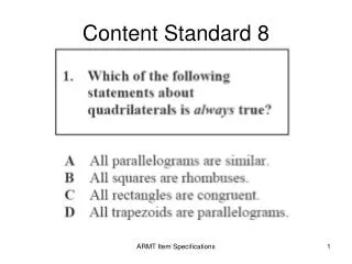
True or False: Example A is from the Framework Base Standard. Answer: False
How does example A relate to example B? A) example A shows the required format and explanations needed to implement a data dictionary for a specific theme such as example B B) example A is the metadata for Example B C) Example A is a subset of the data dictionary in Example B D) Example A references information in Example B Answer: A
Course Home FAQ Glossary References Module summary Framework Data Base Content Standard • Is a set of common requirements shared by the each of the Framework Data Content Standard parts • Provides a foundation on which the seven thematic parts are built • Is not a metadata standard, rather provides methods for describing how data should be structured • Is a reference document to each of the thematic standard parts and sub-parts Next Topic Course Progress Review
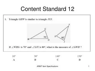
Framework A. the combination of requirements used by all Framework Thematic Standard parts Framework Base Standard Elevation B. one of the 7 Framework themes C. a sub-part of a Framework theme D. a combined set of nationwide spatial data that can be used for GIS projects E. the database where all governmental spatial data is stored Before continuing let's take a break and test our newly acquired Framework knowledge. Click and drag the answer from column 2 to the word or phrase in column 1 that it most correctly defines. Column 1 Column 2 Answer: Framework - D, Framwork Base Standard - A, Elevation - B
Course Home FAQ Glossary References Module 4: Framework Data Content Base Standard Requirements Time Requirement Topics Estimated time for this module is 25 minutes • Framework Data Content Base Standard Requirements • Encoding and Implementing the Framework Standards • Module Exercise and Summary Key Terms Application Schema Data Dictionary Metadata UML XML GML First Topic Framework Data Content Base Standard Requirements
Course Home FAQ Glossary References Framework Data Content Base Standard Requirements • In this module you will learn about the eight different requirements for Framework data, as specified in the Framework Base Standard. Each requirement is addressed as a separate topic, however special attention will be given to the following, as they are the most crucial requirements for creating Framework data: • Application Schema • Data Dictionary • Metadata next Topic Requirement 1: Related Reference Model Schema
ISO 19107Spatial Schema ISO 19133Tracking andNavigation ISO 19123Coverages ISO 19108Temporal Schema ISO 19115Metadata Course Home FAQ Next Topic Glossary Requirement 2: Application Schema ISO 19111 Referencing by Coordinates ISO 19109 Rules for Application Schema References Requirement 1: Related Reference Model Schema Quick Facts The Framework Data Content Standards are all dependent upon concepts addressed in one or more of the ISO 19100 series of geographic information standards. For example, the metadata component implemented by the Framework Base Standard is based on ISO 19115 which specifies requirements for all geographic metadata. The figure to the right details the interactions between the Framework Data Content Base Standard and the ISO 19100 series of standards. All yellow folders are derived from ISO geographic standards. ISO is the short form for the International Organization for Standardization. Since different abbreviations would have been used in different languages, it was decided to use a word derived from the Greek isos, meaning "equal". Therefore, whatever the country, whatever the language, the short form of the organization's name is always ISO. The ISO 19100 series of standards applies specifically to geographic (geospatial) information. <<Application Schema>> Framework (From Logical View) Dependencies on ISO 19100 Series
Course Home FAQ Next Topic Glossary Requirement 3: Data Dictionary References Requirement 2: Application Schema • Each of the Framework Data Content Standards include an integrated application schema. This schema is designed to define the following information content of each data set address. • Feature types • Attribute types • Attribute domain • Feature relationships • Spatial representation • Data organization • Metadata • The Unified Modeling Language (UML) should be used to express this schema. Important UML notes: • UML is not a database or implementation model • UML is an abstract model that shows relationships between elements. • Further UML details are provided in the Encoding section of this module.
Course Home FAQ Next Topic Glossary Requirement 4: Metadata References Requirement 3: Data Dictionary • Each thematic Framework Data Content Standard must contain documentation of all features, attributes, and relationships (including definitions). A data dictionary table should be used to describe and explain the elements outlined in the UML diagram. The data dictionary must conform to the format provided within the Framework Data Content Base Standard, and must include the following six attributes (as defined by the Framework Data Content Base Standard): • Name/Role Name • Definition • Obligation/Condition • Maximum Occurrence • Data type • Domain
Course Home FAQ Next Topic Glossary Requirement 5: Model Integration References Requirement 4: Metadata All datasets shall have metadata that conforms to at least the minimal set of mandatory elements of either ISO 19115, Geographic Information – Metadata, or FGDC-STD-001-1998, Content Standard for Digital Geospatial Metadata, Version 2.0. However, more extensive metadata should be provided. Each thematic standard must specify the metadata necessary for documenting data for that theme. Annex C provides the data dictionary elements from ISO 19115 that are pertinent to the Framework Data Content Base Standard. All metadata elements need to be documented according to the UML application schema for metadata expressed in ISO 19115.
Course Home FAQ Next Topic Glossary Requirement 6: Establishment of a Permanent Identifier References Requirement 5: Model integration The model integration requirement demonstrates each of the abstract concepts of Framework and how each is dependent upon the application schemas for each data theme, as well as the Framework Data Content Base Standard. The integration is based on the ISO profile, which is a general package that outlines the list of standards used by the thematic theme standard parts. See the diagram to the right.
Course Home FAQ Next Topic Glossary Requirement 7: ISO (19109) Feature Model and Notation References Requirement 6: Establishment of a Permanent Identifier Example The table below is an example attribute table from the National Hydrography Dataset (NHD) Reaches, where GNIS_ID is the ‘permanent identifier’ and GNIS_NAME is the ‘namespace’. This requirement establishes the need for permanent identifiers for thematic themes for the purposes of data consistency. If a theme contains features such as roads, waterways, parcels, etc; two fields ‘namespace’ and ‘permanent identifier’ must be included in the UML model for those features; however, it is up to each thematic standard to determine when and how ‘namespace’ and ‘permanent identifier’ will be populated.