Download
1 / 32
320 likes | 518 Vues
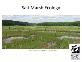
West Solent Waters – A case study of Lymington Salt Marshes. Name:. Linking the following aspects of the specification: Coping with Pressure Increasing Risk Coastal Management. Resources to use:. http://www.school-portal.co.uk/GroupDownloadFile.asp?file=21605 Use Geofile 544 (in folder

E N D
West Solent Waters – A case study of Lymington Salt Marshes Name: Linking the following aspects of the specification: • Coping with Pressure • Increasing Risk • Coastal Management
Resources to use: • http://www.school-portal.co.uk/GroupDownloadFile.asp?file=21605 • Use Geofile 544 (in folder • Geofactsheet 124 (in folder or click below) • http://w1.qehs.net/moodle/mod/resource/view.php?id=7994 • New Forest District Coastal Management Plan – Feb 2004
Haloseres Starter: Google it and watch: http://www.youtube.com/watch?v=3HXyTMnj7ac to find answers to the folowing (5 mins) What are Salt marsh landscapes like? 2, Why are they valuable habitats 3. Why are they at risk? 4. What’s a Halosere?
Part I - Developing your background knowledge of salt marshes • Add the following background information to your pictures (slides 05 to 09) • What is a salt marsh? • Summarise the conditions needed for the formation of salt marshes? • Find (google it!) a sketch or transect (cross section) through a model halosere and annotate this to show: • the changing nature of salt marshes with distance from the sea B) how plant species and coverage changes with distance from the sea
Part II – Conflicts and risk Using: • the following slides • Youtube clip “Lymington Coastal Paths” • Page 224 of the Phillip Allan Textbook • Further reading sources • Annotate a map of the West Solent Waters to identify the specific risks to the Lymington (you could compare these risks to Westhaven salt marshes described in the Geofactsheet • Annotate your map or create a table to show the likely conflicts between user groups (stakeholders) in this area
How did you do? • Lymington residents • RSPB • English Nature • Royal Lymington Sailing Club • Wight link Ferry owners • “Ship Inn” restaurant and pub owner (representing the local economy) • New Forest District Council • Environment Agency • Local farmers in south of lymington and South Baddesley • Boat owner in Lymington Marina • For a full list see the following website: http://www.newforest.gov.uk/index.cfm?articleid=7519&articleaction=nthslnt&CFID=14127605&CFTOKEN=13441266
Part III - Evaluating the management options Adapted from Geofile 544 – Essex Coast Policy 1 – hold the line by maintaining the existing sea wall at Lymington Policy 2 – Advance the line by moving sea defences beyond the existing defences Policy 3 – Managed realignment by identifying a new line of defence and constructing new defences landward of the original defences. Policy 4 - Limited intervention by working with natural processes to reduce risks while allowing natural coastal change. Policy 5 – Do nothing • Which of the following options would you initially • Recommend? • Reject? • How do you decide?
Consider the following steps: • Values analysis and conflict management • Cost benefit analysis • EIAs and ecological value
Cost benefit analysis exercise • Use the following link to describe what this means http://en.wikipedia.org/wiki/Cost_Benefit_Analysis • Using page 245 – of the Phillip Allan textbook and Google Earth – work out the cost of replacing/strengthening the current Lymington seawall with further earth embankments • Is the land worth protecting, thus increasing the chances of coastal squeeze?
Fieldwork and Research It is impossible to protect all coastal areas against development. Conservation needs to be targeted at high value areas. Design a programme of fieldwork and research to decide if West Solent Lymington salt marsh could be considered a “high value area” Use : page 227 of the Phillip Allan Textbook The fieldwork equipment word document Assessing the Impacts of human activity on sand dunes powerpoint (camber sands)
Sharing fieldwork design: Assessing the ecological significance Lets list your Fieldwork activity: Justification of fieldwork design
Secondary research: • Use the following links to: A) To find evidence to suggest the West Solent area is of high ecological significance. B) To help you to make a decision on how to manage the West Solent subcell within the North Solent Shoreline Management Plan • http://www.newforest.gov.uk/index.cfm?articleid=6627&articleaction=nthslnt&CFID=14127605&CFTOKEN=13441266 • http://www.newforest.gov.uk/index.cfm?articleid=6582&articleaction=nthslnt&CFID=14127605&CFTOKEN=13441266 • http://www.newforest.gov.uk/index.cfm?articleid=7825&articleaction=nthslnt&CFID=14127605&CFTOKEN=13441266 • http://www.solentpedia.info/
Part IV - Decision Making Exercice • Using your knowledge of Essex, camber sands and Westhaven saltmarshes and your case study so far: • Briefly justify your choice of coastal defence strategy for Lymington salt marshes • Give reasons for rejecting the other policy options.
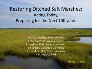
Managed Realignment “Where there is insufficient economic reason to upgrade defences there may be opportunities to let the shoreline naturally realign itself. However, such an option may not be practical due to a number of reasons, for example, land use, landownership and nature conservation reasons.” In order for coastal protection and flood defence schemes to gain permission and receive central government funding they must be economically justifiable, technically viable and environmentally acceptable. The Coastal Defence Strategy will provide recommendations for the management of coastal defences over a 100 year period and a prioritised programme of works for the first 5 years.
Click on the following link and look for the pdf files to the right to see the current shoreline management plan for this area http://www.newforest.gov.uk/index.cfm?articleid=6554&articleaction=nthslnt&CFID=14127605&CFTOKEN=13441266