Download

1 / 26
270 likes | 397 Vues
Development of TP Regional Precipitation Datasets and Products: need and progress. Daqing Yang National Hydrology Research Centre (NHRC) Environment Canada (EC), Saskatoon, Canada Yinsheng Zhang, Yingzhao Ma Institute of Tibetan Plateau Research Chinese Academy of Sciences

E N D
Development of TP Regional Precipitation Datasets and Products: need and progress Daqing Yang National Hydrology Research Centre (NHRC) Environment Canada (EC), Saskatoon, Canada Yinsheng Zhang, Yingzhao Ma Institute of Tibetan Plateau Research Chinese Academy of Sciences 3rd TPE Workshop, Sept 1, 2011
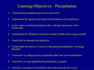
Need for P Data and Products • Climate: key variable to define climate and its change • Glacier: accumulation and mass balance • Hydrology: flood/drought, water budget, and input to models • Snowcover: mass/energy balance, avalanche • Ecosystem: water supply, NDVI - P relation, vegetation change vs. precip impact • Human: transportation, recreation, cultural • 2nd TPE workshop report • 1# product: Precip (when, where, how much, form, and trend) • TPE atlas, i.e. basin/regional hydroclimatology
Meteorological Stations over TP • Network: density and distribution • Data quality: • - space/time discontinuity • - obs biases
Biases and Correction Method Pc = K Pg + Pw + Pe + Pt Pc- corrected precipitation Pg - gauge-measured precipitation Pw - wetting loss Pe - evaporation loss Pt - trace precipitation K - correction coefficient for wind-induced undercatch
(Yang et al, 1991) (Goodison et al., 1998) Gauge Precipitation Daily Correction Coefficient (K) Part Ⅰ Bias-corrected Precipitation Reliability Evaluation TRMM 0.25° 3B42_V6 Product FTP Download NASA Website TRMM Precipitation DEM Part Ⅱ Part Ⅲ Homogenized and corrected Precipitation Dataset Project Flowchart: Homogenized and Corrected Precipitation Dataset over TP
WMO Solid Precipitation Measurement Intercomparison, manual and auto gauges
WMO Double Fence International Reference(DFIR) for Solid Precipitation Secondary reference
WMO Solid Precipitation Measurement Intercomparison sites and people Barry Goodison Chairman, International Organizing Committee Canada Barry Goodison Paul Louie John Metcalfe Ron Hopkinson China Daqing Yang Ersi Kang Yafen Shi Croatia Janja Milkovic Denmark Henning Madsen Flemming Vejen Peter Allerup Finland Esko Elomaa Reijo Hyvonen Bengt Tammelin Asko Tuominen S. Huovila India N. Mohan Rao B. Bandyopadhyay Virendra Kumar Col K.C. Agarwal Germany Thilo Günther Japan Masanori Shiraki Hiroyuki Ohno Kotaro Yokoyama Yasuhiro Kominami Satoshi Inoue Norway Eirik Førland Romania Violete Copaciu Russian Federation Valentin Golubev A. Simonenko Slovakia Miland Lapin Sweden Bengt Dahlstrom Switzerland Boris Sevruk Felix Blumer Vladislav Nešpor UK J. Fullwood R. Johnson USA Roy Bates Timothy Pangburn H. Greenan George Leavesley Larry Beaver Clayton Hanson Albert Rango Douglas Emerson David Legates P. Groisman WMO Klaus Schulze Stephan Klemm CRN modified DFIR • Intercomparison was the result of Recommendation 17 of the ninth session of the CIMO-IX. • Started in the northern hemisphere winter of 1986/87. • Field work carried out at 26 sites in 13 Member countries for 7 years • Final report WMO-TD no. 827 published in 1998
WMO Intercomparison Study Results: Catch Efficiency vs. Wind for 4 most widely used gauges Daily time scale
Report and Publication • About 30 papers in international journals • National reports • WMO TD, No- 827, 1998 Barry Goodison, Paul Louie, and Daqing Yang, the 14th Professor Vilho Vaisala Award in 1998
Recommendations from the WMO Intercomparison Study • WMO correction methods (available for different types of gauges and for different types of precipitation and various time intervals) should be adopted and applied to current and archived data; • both measured and corrected precipitation data should be reported and archived; • trace precipitation should be treated as a non-zero event; effort to determine mean trace amount is needed in Arctic conditions; • additional wind speed measurements be taken at the level of the gauge orifice and hourly mean wind data be archived in order to correct for wind-induced undercatch; • use of heated tipping-bucket gauges for winter precipitation measurement should be carefully assessed; their usefulness is severely limited in regions where temperatures fall below 0C for prolonged periods of time; • timing and type of precipitation be recorded by automatic instruments in order to conduct the correction on the basis of precipitation event.
Mean Gauge-Measured (Pm) and Bias-Corrected (Pc) Precipitation, and Correction Factor (CF) for January a) Pm (mm) b) Pc (mm) c) CF • Total 4827 stations located north of 45N, with data records longer-than 15 years during 1973-2004. • Similar Pm and Pc patterns – corrections did not significantly change the spatial distribution. • CF pattern is different from the Pm and Pc patterns, very high CF along the coasts of the Arctic Ocean.
Impact of Bias-Corrections on Northern Hydrology: CLM3 simulations with/without P corrections, 1973-04 5~25%
5 5 5 5 c . Pc - Pm (mm) 650 Annual precip bias-corrections in China, 1951-1998 (Ye et al. 2003, JHM) 2400 a. Pm (mm) 600 5 0 2200 5 0 550 2000 500 1800 4 5 4 5 450 1600 400 1400 4 0 350 1200 4 0 300 1000 800 250 3 5 3 5 600 200 500 150 3 0 3 0 400 100 300 50 2 5 200 2 5 25 150 10 100 2 0 5 2 0 50 0 0 80 90 100 110 120 130 80 90 100 110 120 130 5 5 5 5 5 5 Corrected annual mean precipitation (mm) d. (Pc – Pm) / Pm (%) 75 2800 b. Pc (mm) China, 1951-98 70 2600 5 0 5 5 0 0 2400 65 2200 60 4 5 4 4 5 5 2000 55 1800 50 4 0 1600 4 4 0 0 45 1400 1200 40 3 5 3 3 5 5 1000 35 1000 800 3 0 30 3 3 0 0 600 25 500 2 5 20 400 2 2 5 5 200 15 100 2 0 10 2 2 0 0 50 5 0 80 90 100 110 120 130 80 80 90 90 100 100 110 110 120 120 130 130
150 a 100 y = 1.08x - 4.9323 50 R 2 = 0.9442 0 precipitation (mm/10a) Trend in corrected annual -150 -100 -50 0 50 100 150 -50 -100 1:1 -150 Trend in measured annual precipitation (mm/10a) Trend Comparison, measured vs. corrected annual precipitation, 670 stations in China,1951-98 Average trend for all stations: + 0.5mm/10a for measured precip - 4.5mm/10a for corrected precip 20 1:1 b 15 y = 0.8938x - 0.5987 10 R 2 = 0.9661 5 precipitation (%/10a) Trend in corrected annual 0 -20 -10 0 10 20 -5 -10 -15 -20 Trend in measured annual precipitation (%/10a)
P = R + E or E = P – R • P undercatch -> E underestimation ???
(Yang et al, 1991) Gauge Precipitation Daily Correction Coefficient (K) Part Ⅰ Bias-corrected Precipitation Reliability Evaluation TRMM 0.25° 3B42_V6 Product FTP Download NASA Website TRMM Precipitation DEM Part Ⅱ Part Ⅲ Homogenized and corrected Precipitation Dataset Project Flowchart: Homogenized and Corrected Precipitation Dataset over TP
Sample of TRMM product • weekly accumulation, TRMM-precipitation estimation in Asia, • global 0.25° * 0.25° grid over the latitude band 50°N-S • about seven hours of observation time. • Key question: TRMM winter data for solid and mixed precip over the mountain regions, i.e. TPE
EC Snow Workshop, Toronto Dec 01, 2010 Rodica Nitu DFIR Bratt’s Lake Intercomparison Facility/Smith Geonor-DF - - - Barrow, UAF Wyoming snow fence, Mar/03 Barrow, UAF DFIR, Mar 03 Barrow, UAF DFIR, Mar 3/03 WMO Solid Precipitation Inter-Comparison Experiment (WMO-SPICE) -
CIMO-XV (Sept 2010) • An instrument intercomparison for solid precipitation measurements at AWS: a priority! • WMO-SPICE: WMO Solid Precipitation Instrument Intercomparison Experiment • Canada committed to a leadership role if other Members participate and share the work • Support and commitment expressed: China, Finland, Japan, New Zealand, Switzerland, Russian Federation, and USA. • In CIMO, SPICE positioned in the context of WIGOS, EC-PORS, GCW.
WMO-SPICE: Proposed objectives • Evaluate the performance and configuration (catching, non-catching type, instrument & shield) of measurements in field conditions; • Develop multi-parameter algorithms to improve AWS precipitation data; • Develop adjustment procedures of systematic errors; • Establish a field reference standard using automatic gauges; • Develop long-term capacity to support validation of satellite measurements (e.g. Global Precipitation Measurement); • Develop comprehensive datasets to support future research objectives; • Provide feedback to manufacturers; • Pilot project for WIGOS, EC-PORS, GCW.
Proposed Ancillary Measurements • Radar – for horizontal (PPI scans) and vertical profiling (RHI or Vertical scans) for variation of precipitation. Dual-pole for precipitation typing. • Radiometer – determine the presence of liquid water (determine if particles are rimed). • Wind measurements (3D anemometers) – for turbulence, gustiness, at sensor height. • Precipitation Type Sensors – present weather sensors, intensive human observations. • Temperature and humidity – point and profiling, to determine habit types • Particle size, particle density and shape information – for aerodynamic collection efficiency issues; • Snowpack properties – snow depth, snow morphology, snow (freshly fallen and snow pack) density; • Lidarfor cloud properties; • Upper Air soundings for air mass stability.
Summary • Large biases/errors in historical gauge precipitation data • Bias corrections necessary, using WMO methods and station meta data/info • Impacts of precip bias corrections • changes in max P, mean, variation, and trend • SWE, snowmelt runoff, river flow, water and energy budget • Needs: • compatibility among gauge observations, manual vs. auto gauges (including TPE networks/stations) • test of auto gauges and instruments – WMO/SPICE • validation of RS P/snowfall data over the cold regions • TPE P working group/project???