Download

1 / 27
270 likes | 506 Vues
Stochastic Optimization Model Using Remote Sensing Technology for Agricultural Management in Africa. Wesonga Ronald Institute of Statistics and Applied Economics, Department of Planning and Applied Statistics, Makerere University PO. Box 7062 Kampala UGANDA. Email: wesonga@wesonga.com

E N D
Stochastic Optimization Model Using Remote Sensing Technology for Agricultural Management in Africa Wesonga Ronald Institute of Statistics and Applied Economics, Department of Planning and Applied Statistics, Makerere University PO. Box 7062 Kampala UGANDA. Email: wesonga@wesonga.com Website: http://www.wesonga.com
Outline • Abstract • Introduction • Agricultural Management in Africa • Climate Change and Agricultural Management in Africa • Remote Sensing technology in Agricultural Management in Africa • Agriculture Management Problems • Remote Sensing Technologies for Agric • Wavelength Region Correlation • EumetsatApplications Facilities • Drought Monitoring using MSG Satellite data • Stochastic Optimization Model for Agricultural Production in Africa • Discussion • Conclusion and Recommendations ICAS-IV Beijing China - ICT Session
Abstract • Information communication technology is the key to agricultural development if less developed countries (LDCs) are to optimize agricultural management (Di Bella, 2004). • limited accessibility to ICTs, LDCs still lag behind in exploiting technologies for timely decision making in agricultural management (ElisabettaCarfagna, 2005). • Agricultural management in Africa is hampered by among other parameters the uncertainties that surround the following questions: when is the next rainy season? How long are the next rains expected to take? What is the likely intensity of these rains? Are they sustainable? What if we planted now? Are we likely to gain if we waited for two more months? How do we determine the disease or pest attaching our plants? How about if we used the other chemical/fertilizer? • We also present a model that attempts to minimize the common phenomenon in LDCs of time wastage between planting of crops, hence optimization of agricultural management in Africa. ICAS-IV Beijing China - ICT Session
Introduction • Satellite imagery and related information and communication technology are the most important avenues of information and knowledge discovery, an aid to making timely, accurate and informed decisions in agricultural production in the world. • The Meteosat Second Generation spacecraft was designed to take advantage of new technologies and to improve on the already successful and proven spacecraft design of the original Meteosat satellites. The SEVIRI radiometer on-board the MSG satellite has a total of 12 channels that scan images of the earth every 15 minutes (Project, 2004). ICAS-IV Beijing China - ICT Session
Agricultural Management in Africa • Agriculture is undoubtedly the most important sector in the economies of most non-oil exporting African countries. It constitutes approximately 30% of Africa's GDP and contributes about 50% of the total export value, with 70% of the continent's population depending on the sector for their livelihood. • (Mike Hulme, 2000) discussed the five main climate change related drivers: temperature, precipitation, sea level rise, atmospheric carbon dioxide content and incidence of extreme events • The impact of these adverse climate changes on agriculture is exacerbated in Africa by the lack of adapting strategies, which are increasingly limited due to the lack of institutional, economic and financial capacity to support such actions plus limited ICT usage for the monitoring such as remote sensing technologies. ICAS-IV Beijing China - ICT Session
Climate Change and Agricultural Management in Africa • Agriculture in low latitude developing countries is expected to be especially vulnerable because climates of many of these countries are already too hot • Further warming is consequently expected to reduce crop productivity adversely • reductions of impacts across regions consequently suggest large changes in the agricultural systems of low latitude mostly, developing countries ICAS-IV Beijing China - ICT Session
Using Remote Sensing technology in Agricultural Management in Africa • remote sensing refers to the activity of using electromagnetic properties to view or interpret phenomena while not physically in contact with it ICAS-IV Beijing China - ICT Session
Eminent Agric mngt problems in Africa solvable by remote sensing techniques Reliability of data Cost and benefits Timeless Incomplete sample frame and sample size Methods of selection Measurement of area Non sampling errors Gap in geographical coverage Non availability of statistics at disaggregated level.
Remote Sensing techniques for Agricultural management The following factors influence the use of remote sensing in agricultural surveys Characteristics of the agricultural landscape Detection, identification, measurement and monitoring of agricultural phenomena are predicated on the assumption that agricultural landscape features e.g. crops, livestock, crop infestations and soil anomalies have consistently identifiable signatures on the type of remote sensing data. Some of the parameters which may cause these identifiable signatures include crop type, state of maturity, crop density, crop geometry, crop moisture, crop temperature, soil moisture, soil temperature.
Remote Sensing techniques for Agricultural management cont’d • Characteristic of EMR on Agricultural management Factors that evidently affect soil reflectance are moisture content, soil texture, surface roughness and presence of organic matter. Determination of spectral signatures implies basic understanding of interaction of electromagnetic radiation with agricultural resources management. ICAS-IV Beijing China - ICT Session
Use of wavelength region Correlation ICAS-IV Beijing China - ICT Session
Eumetsat Satellite Applications Facilities • African National Meteorological Services, in close partnership with others involved with development in Africa, and in addition to the traditional meteorological services, develop applications in the following fields: Water Development and Management, Flood Forecasting and Monitoring, Flood Damage Assessment, Agricultural Management, Landslide Risk Monitoring, Food Security, Post Crisis Food Aid Assessment, Forest Fire Monitoring, Forest Fire Risk Assessment, Land Cover Changes and Pest Monitoring • Other products delivered by the VGT4AFRICA partners include: NDWI-water index, burnt area, phenology, small water bodies, albedo and fcover ICAS-IV Beijing China - ICT Session
Drought Monitoring using MSG Satellite data • The EUMETSAT Satellite Application Facility on Land Surface Analysis (LSA SAF) led by the Portuguese National Meteorological Service, has been used to monitor desertification and drought threatened areas, providing an important source of information to combat environmental degradation • The operational Land SAF products are available free of charge in near real time via EUMETCast – EUMETSAT’s Broadcast System for Environmental Data that is accessible to Africa. ICAS-IV Beijing China - ICT Session
Stochastic Optimization Model for Agricultural Production in Africa • The model developed in this paper seeks to help decision making by obtaining an optimal situation to minimize unnecessary delays in agricultural production using stochastic modeling • Decisions made in agricultural production depend on a number of parameters including the stochastic weather conditions which also resolve a number of things among which are the planting and harvesting periods, besides whether or not a crop will successfully grow within a predetermined time period ICAS-IV Beijing China - ICT Session
The Model ICAS-IV Beijing China - ICT Session
Notation and definitions ICAS-IV Beijing China - ICT Session
Decision variables ICAS-IV Beijing China - ICT Session • Assumptions • System – field/farm is empty(no crops) at the beginning of the planning period • All crops grow and are harvested by the end of period T+1
Some sample data – model validation ICAS-IV Beijing China - ICT Session
Some sample data – model validation ICAS-IV Beijing China - ICT Session
Discussion • Agricultural delays of crops in Africa is a function of the time period amongst other parameters. • Some time periods are more favored with the necessary optimal weather and resource facilitation than other time periods resulting into difference in cost of production • Quite often the weather parameter is stochastic in nature and tends to vary in an unpredictable way such that for the majority of peasants in Africa, a whole season or more may go without any agricultural production. • These delays are actually a source of food insecurity and hunger in Africa as a whole despite the vast amount of productive land. • The question of how to minimize agricultural production delays for crops was the major concern in this paper ICAS-IV Beijing China - ICT Session
Conclusion and Recommendations • In order to maintain a consistent and sustainable agricultural production, one requires perfect knowledge of a number of parameters necessary for agricultural management that may be possible with use of the available remote sensing technologies such Meteosat Second Generation satellite data • Study recommends use of tools such as the stochastic optimization model developed in this paper • It was showed that to minimize the cost of production while maintaining agricultural production throughout the year, λ, the cost ratio of production between unfavorable and favorable seasons should be kept as close to one as possible, by having just in time decisions through use of MSG satellite data • It is recommended that there should be coordination of activities in different ministries of African Governments ICAS-IV Beijing China - ICT Session
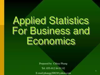
Some satellite imagery ICAS-IV Beijing China - ICT Session
1.6 0.8 0.6
NATURAL COLOURSphysical interpretation Red Cloud depth as well as snow/ice and droplet differentiation, provided by the visible reflectance at 1.6mm. Green Cloud depth and “greenness” of vegetation, provided by visible reflectance at 0.8mm. Blue Cloud depth, some haze and non green-sensitive land surface information, provided by reflectance at 0.6mm.
References • Barry, L. N. (2003). Stochastic modelling: analysis and simulation. London: Dover Publications, Inc. • Campbell, J. B. (2006). Introduction to Remote Sensing. London: Guildford Press. • Chalmers, N., Fabricius C. . (2007). Expert and Generalist Local Knowledge about Land-cover Change on South Africa’s Wild Coast: Can Local Ecological Knowledge Add Value to Science? . Ecology and Society, 12(1), 10. • David A. Stainforth , T. E. D., Richard Washington, Ana Lopez, Mark New. (2007). Issues in the interpretation of climate model ensembles to inform decisions The Royal Society, 365 (1857), 2163-2177. • Di Bella, F. R., Ruget F. , Seguin B. , Guérif M. , Combal B. , Weiss M. ,Rebella C. . (2004). Remote sensing capabilities to estimate pasture production in France International Journal of Remote Sensing, 25(23), 5359 - 5372. • ElisabettaCarfagna, J. G. F. (2005). Using Remote Sensing for Agricultural Statistics. International Statistical Review, 73(3), 389–404. • EsteveCorbera, D. C., Marisa Goulden, Katharine Vincent. (2006). Climate Change in Africa: Linking Science and Policy for Adaptation. The Royal Society, London. • Kiniry, J. (2006). A General Crop Model Proceedings of ARS/INIFAP Binational Symposium on Modeling and Remote Sensing in Agriculture • Kyllo, K. P. (2003). NASA funded research on agricultural remote sensing. Department of Space Studies, University of North Dakota. ICAS-IV Beijing China - ICT Session
References Cont’d • Lillesand, T. M., Kiefer, R. W., Chipman, J. W. (2004). Remote sensing and image interpretation. Madison, Wisconsin, USA.: John Wiley & Sons Ltd. • Mike Hulme, R. D., Todd Ngara, Mark New, David Lister. (2000). African Climate Change: 1900-2100.Unpublished manuscript. • Moazenpour, M. A., Farshad A.A. Abkar. (2006). Use of remote sensing in Pistachio yield estimation. ISHS ActaHorticulturae 726: IV International Symposium on Pistachios and Almonds • Project, M., Unit. (2004). Introduction to the MTAP component outlook. Paper presented at the Conference Name|. Retrieved Access Date|. from URL|. • Richardson Clarence, B.-G., Alma, Tiscareno-Lopez Mario. (2004). Modeling and Remote Sensing Applied to Agriculture (U.S. and Mexico) Proceedings of ARS/INIFAP Binational Symposium on Modeling and Remote Sensing in Agriculture. • Schowengerdt, R. A. (2006). Remote Sensing: Elsevier. • Sergio M. Vicente-Serrano, J. M. C.-P., Alfredo Romo. (2006). Early prediction of crop production using drought indices at different time-scales and remote sensing data: application in the Ebro Valley (north-east Spain) International Journal of Remote Sensing, 27(3), 511 - 518 • Taube, A., Ondongo Pierre (2004). Report of the sixth Eumetsat user forum in Africa. Darmstadt, Germany: EUMETSAT. • Van Niel, T. G., McVicar, T. R. . (2004). Current and potential uses of optical remote sensing in rice-based irrigation systems: a review. Australian Journal of Agricultural Research, 55 (2), 155 - 185. • www.vgt4africa.org • www.eumetsat.int ICAS-IV Beijing China - ICT Session
Acronyms • LDC Least Developed Country • ICT Information Communication Technology • MSG Meteosat Second Generation • SEVIRI Spinning Enhanced Visible and Infrared Imager • NDWI Normalised Difference Water Index • GERB Geostationary Earth Radiation Budget • GEOSAR Geographic Synthetic Aperture Radar • GDP Gross Domestic Product • MTA Meteorology Transition Africa • VGT4AFRICA Vegetation for Africa • EUMETSAT European Meteorological Satellite • LSA Land Surface Analysis • SAF Satellite Application Facility • UN United Nations • MDG Millennium Development Goal ICAS-IV Beijing China - ICT Session