Real-time Surface Currents in the Chesapeake Bay: Coast Guard Operations
10 likes | 124 Vues
Explore how high-frequency radar data aids Coast Guard operations in monitoring surface currents in the Lower Chesapeake Bay, assisting in search and rescue missions and response planning. Real-time comparisons and visualizations provided.

Real-time Surface Currents in the Chesapeake Bay: Coast Guard Operations
E N D
Presentation Transcript
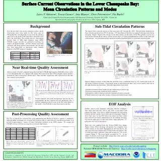
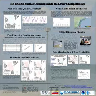
HF RADAR Surface Currents: Inside the Lower Chesapeake Bay Coast Guard Search and Rescue Near Real-time Quality Assessment Mid-Atlantic offshore HFRADAR data are fed into the Coast Guard Search And Rescue OPerations (SAROPS) database (Fig. 7). Data in the bays are not yet included in SAROPS. However, Coast Guard Sector Hampton Roads receives one or more distress calls on most days of the year and we wish to make some information available for the local area. Several of these boating distress calls originate from popular fishing spots near the Chesapeake Bay Bridge Tunnel Islands. Short time histories of currents at the four islands are updated hourly on the ODU HFRADAR website (Fig. 6). Surface current velocities computed using data from three CODAR high frequency RADAR systems in the Lower Chesapeake Bay are compared with current observations from three NOAA Doppler current profilers mounted on Aids- to-Navigation (ATON) buoys. Near real-time comparisons offer a quick look at how the data compare at any moment. TS YS CH Figure 6. Vector time history of currents at a location identified as a “hot spot” for boating incidents by the local Coast Guard. Despite temporal and spatial discrepancies between the two measurements, the data compare very well qualitatively (Fig. 2) and this comparison serves as one of the first order checks of the validity of the RADAR system observations in the Bay. Figure 7. Offshore Mid-Atlantic HFRADAR data is fed into the Coast Guard Search & Rescue Operations database. This image is taken from the Scripps CORDC website. Figure 2. Near real-time comparisons of 6 minute NOAA ADCP data (blue) and hourly CODAR data (red) at (YS) York Spit (CH) Cape Henry and (TS) Thimble Shoals. Figure 1. Locations of CODAR antenna sites (red) and NOAA PORTS Doppler current profilers (blue) in the lower Chesapeake Bay shown on a map of current velocities produced from the RADAR data. Oil Spill Response Planning Post-Processing Quality Assessment Discussions are ongoing with a local Coast Guard group tasked with developing a Geographic Response Plan to prepare for oil and factory pollutant spills within the Lower Bay and nearby rivers. We can provide this group with average sub-tidal information, such as in Figure 4, to assist in their planning. Comparisons with City of Norfolk AWAC data collected by Moffatt & Nichol The City of Norfolk has contracted the ocean engineering firm Moffatt & Nichol to operate a continuously deployed AWAC instrument off of Ocean View beach in order to collect data for a beach erosion model. It is moored in approximately 7 meters of water 2 kilometers northeast of the VIEW antenna. We compare the CODAR velocities with this mooring data over several deployments. This group is also investigating the use of oil spill software. They recently tested out a modeling package called PISCES at an oil spill training exercise conducted at Western Refining (Figs. 8 & 9). In the event of an actual spill, a program operator has the ability to include real-time observations of currents into the model. Figure 9. Oil spill training exercise at Western Refining on the York River. Figure 8. PISCES model output during training exercise. Data Visualizations & Data Availability Table 1. Mean and root-mean-square statistics for the difference in velocity between the Doppler profiler and CODAR in U and V components for four deployment periods. Figure 3. Scatter plots of ADCP data versus CODAR data for U and V velocity components during AWAC deployment 7 (Nov 13 2007 19:00 - Mar 7 2008 12:00 UTC). Sub-tidal Circulation Patterns Figure 11. Examples of particle trajectories. Figure 10. Surface current velocities in shipping channels. Check the ODU HFRADAR website for the latest surface current information in the lower Bay. Data are freely available on the web, from our servers or from federal sites. Data products may be specifically tailored to suit individual agency or company needs upon request. For example, when we learned that the Marine Spill Response Corporation was referencing the HFRADAR data for training exercises, we designed a web page specifically for this group. There are many ways to present the data depending on the interest of the user group (Figs. 10, 11, & 12). If you think you may have a use for this type of data, please work with us. We can develop prototype products or work on ways to transfer our data to you. Figure 4. The average sub-tidal circulation pattern for the Lower Bay indicates typical estuarine outflow exiting at the southern end of the Bay mouth. It also shows a recirculation pattern outside the mouth of the James River. Figure 12. Alongshore currents off of Ocean View Beach. Figure 5. Average sub-tidal circulation patterns under different wind forcing conditions. Project website: http://www.ccpo.odu.edu/currentmapping National HFRADAR Network Gateway: http://cordc.ucsd.edu/projects/mapping CONTACT ACKNOWLEDGMENTS This project is supported by the Center for Innovative Technology (CIT) and the National Oceanic and Atmospheric Administration (NOAA) through the Mid-Atlantic Coastal Ocean Observing System (MARCOOS). Center for Coastal Physical Oceanography Old Dominion University, Norfolk, VA 23529 Teresa Garner (garner@ccpo.odu.edu) Jose Blanco (jlblanco@ccpo.odu.edu) Larry Atkinson (latkinso@odu.edu)