Mass Wasting and Slope Stability
170 likes | 303 Vues
This advanced course focuses on the physics of Earth's surface, exploring physical and chemical processes shaping landscapes, with an emphasis on mass wasting and slope stability. The curriculum integrates lectures with lab work to reinforce concepts in stratigraphy and in situ strength estimation. Students will engage in group labs that involve creating stratigraphic columns, measuring slide morphometry, and analyzing sediment sizes. The course fosters scientific habits, effective communication, and hands-on skills, culminating in a written report showcasing their findings.

Mass Wasting and Slope Stability
E N D
Presentation Transcript
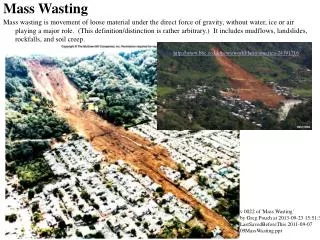
Mass Wasting and Slope Stability Jeff Clark Lawrence University
Course Details • Physics of the Earth: Surficial Environments • Physical and chemical processes that shape Earth’s surface • Focus on a few in depth • Lecture and lab coupled • Moving to integrate “field technology” • Required 300 level course (prereqs) • ~ 9 2/3 weeks (8-9 3-hr* labs) • 6-10 students
Lab Context • Third and fourth labs of term • depth • Follows basic mapping and soils labs • Lectures on mechanical weathering, slope stability, and mass wasting concurrent. • All labs are group labs • First “formal” lab write up
Goals of Lab • Reinforce and build upon concepts/skills • Soils from previous labs and lectures • Mass wasting and slope stability • Strat columns • New field and lab techniques • In situ strength estimates • Morphometric indices • Aerial rephotography • Sediment size analysis – fine fraction
Goals of Lab • Scientific Habits of Mind • Sound observations to support inferences • Synthesis of multiple observations/data sets • Effective communication • Written report with tables, figures, methods, results, discussion, etc. • Other labs have oral or poster style communication forms
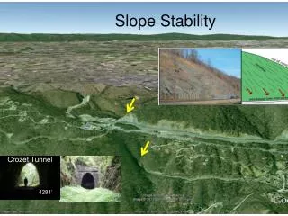
Lab Activities • Create stratigraphic column • Measurements, sampling, and observations • Measure slide morphometry • Use survey skills and identify slide features • Map present shoreline and cliff • Relate to historic shoreline position
Top 5m of strat column • Describe color, texture • Measure strength • Sample From GeoTest
Mophometric Index D/L Crozier, 1973; reprinted in Ritter, Kotchel and Miller, 2002
Mophometric Index D/L Crozier, 1973; reprinted in Ritter, Kotchel and Miller, 2002
Second Week • Determine rates of retreat – GIS • Hydrometer analysis • Correlate with strength • Moisture content? • Revisit site? • Compile report
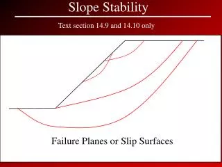
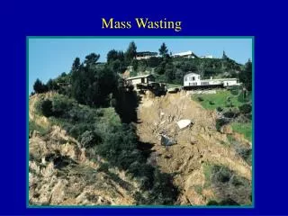
Why does this lab “work” • Multiple clear “textbook” possibilities for failure mechanism • Wave-cut toe, profoundly weak layer, pore water, historic changes in lake level • Several Possible interpretations • Requires synthesis of different types of observations/measurements
Problems • Reports – students need guidance on structure and content • Use background reading article as model? • Data sharing is problematic • Try electronic field forms/notebooks • Students tend to wait until the second week to work on project • Build in credit bearing check points • Too ambitious even for groups • May remove GPS mapping in future