Urban Patterns
Urban Patterns. AP Human Geography. Urban Geography. Urban refers to highly developed areas where businesses, people, and industry cluster. Not limited to big cities….also includes sub- urban areas. Where are people and activities distributed in urban areas?


Urban Patterns
E N D
Presentation Transcript
Urban Patterns AP Human Geography
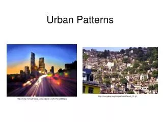
Urban Geography • Urban refers to highly developed areas where businesses, people, and industry cluster. • Not limited to big cities….also includes sub-urban areas. • Where are people and activities distributed in urban areas? • What patterns develop in urban areas?
Central Business District (CBD) • Aka “Downtown” • Less than 1% of land area • High % of services, public institutions • High accessibility • Focal point of transportation
Who locates in the CBD? • Retailers w/ high threshold • Ex. Department stores • Now replaced by malls • Retailers w/ high range • Specialists, unique shops • Retailers serving downtown workers • Office supplies, coffee shops, dry cleaning, fast food restaurants
Characteristics of the CBD • Large public buildings such as libraries, churches, stations and town halls. • Specialty shops and branches of major department stores. • Movie theatres, clubs and theatres. • Very little housing, but often hotels. • Little or no industry. • Offices and other professional buildings. • High pedestrian levels and the greatest parking restrictions. • Geographical center of the settlement. • Area with the highest land value. • Well connected by public transport, with large numbers of passengers. • High traffic levels.
Land Use in CBD’s • Land is expensive in CBD’s • Tokyo, London, NYC • High cost of land forces vertical and underground expansion • Skyscrapers • Underground cities
Worlds Most Expensive Land Cost of Land per square meter Land in LDC’s might be closer to $3-15 per square meter Rural land is cheaper than urban land • 1. Monte Carlo, Monaco – $47,5782. Moscow, Russia – $20,8533. London, England – $20,7564. Tokyo, Japan – $17,9985. Hong Kong – $16,1256. New York, USA – $14,8987. Paris, France – $12,1228. Singapore – $9,7019. Rome, Italy – $9,16610. Mumbai, India – $9,163
Not Found in CBD’s • Industry • Have relocated to suburban areas • Old industrial areas (harbors/ piers) are now tourist attractions • Ex. Navy Pier • Residents • Fluctuation: originally rich mansions and crowded apts., then suburbs, now “empty nesters” return in search of nightlife, entertainment, etc.
Urban Models • 3 models, all developed in Chicago • Why Chicago? • Flat (prairie) • Few physical features that interrupt growth (except Lake Michigan) • Predict how cities will develop • Where will different groups of people live in urban areas?
Concentric Zone Model • E.W. Burgess • City grows outward in a series of rings • 5 Rings • 1. CBD • 2. Transition (industry/ poor housing) • 3. Working class • 4. Better homes • 5. Commuters/ suburbs
Sector Model • Homer Hoyt • City develops in sectors (sections/ wedges) not rings. • Industry and retail develop along transportation lines
Multiple Nuclei Model • Harris and Ulmann • Multiple nodes (centers) around which activities revolve. • Certain activities choose to locate in certain nodes. • Ex. • Bookstores and bars near college campus • Hotels and warehouses near airport
Latin American Model • Wealthiest residents live in CBD and long a commercial spine. • CBD features a market and town square, left over from colonial days.
Sub-Saharan African Model • DeBlij • 3 CBD’s • Colonial (vertical) • Traditional (single story shops) • Market Area (open air market) • Satellite townships on the edge.
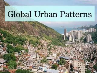
Informal Settlements • Squatter settlements, favelas (Brazil), townships (Africa), slums, etc. • 175 million world wide • Large numbers of people migrate to cities rapidly; cities cannot keep up with growth. • Poorly constructed houses. • Lack basic services: schools, water, electricity, paved roads, sewers.