Download
1 / 3
30 likes | 182 Vues
FEMA - USGS Geo-spatial Support FEMA Region VIII March 27 th , 2008. Remote Sensing Team (RST).

E N D
FEMA - USGS Geo-spatial Support FEMA Region VIII March 27th, 2008
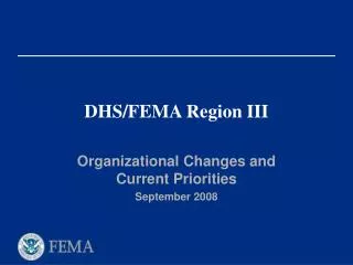
Remote Sensing Team (RST) • The Remote Sensing Team (RST) will consult and coordinate to determine the Tasking, Collection, Processing, Exploitation and Dissemination (TCPED) process for all Remote Sensing assets (commercial, Intelligence Community, civilian, internal DHS, DoD and State) in support of an emergency response. It is an organizational component of the Incident Command System (ICS) and will expand and contract according to the size and scope of the event. The goal of the RST is to provide visibility of all aspects of the TCPED process for the entire Remote Sensing Community while providing support to all our Federal, State, local and tribal partners of the emergency management community without duplication of effort. • The RST is a group of resources with a common communications and a leader, that may be pre-established and sent to an incident or formed at an incident and may include the following sources and possible leads: • Commercial Sector - USGS is the executive agent for all commercial contracts. • Intelligence Community - NGA; • Civil Agencies - USDA or NASA; • DHS - Office of Intelligence & Analysis • DoD - NORTHCOM / AFNORTH • State - Emergency Operation Center Geospatial Liaison (CAP / ANG) The RST will be under the direct supervision of the Team Leader, the FEMA Remote Sensing Coordinator, who reports directly to the Planning Section Chief of the Joint Field Office (JFO), the Regional Response Coordination Center (RRCC) or the National Response Coordination Center (NRCC).
Streaming Data Commercial/Civil Agency/Internal DHS Static Data Commercial, DoD, NGB, Other Civil Real Time Downlink Media TCPED Process Collection Tasking FEMA JFO/RRCC/NRCC Feedback Requirements Remote Sensing Team Timeliness Accessibility Security I/C-NTM Collection Pre-Scripted Mission Assignments I/C-NTM Tasking I/C Requirements I/C-NTM Exploitation Classified Feedback Static Data Full Res Video Dissemination Exploitation Processing FTP Media (Zip and Ship) iCAV HSIN USGS Seamless/HDDS Other Web Mapping Service Google Earth FEMA MAC Commercial (USGS) DoD (Unclassified) Other Civil Agency NGB State Local Thick Client Commercial (USGS) Internal DHS DoD (Unclassified) Other Civil NGB Analysis/Fusion Thin Client Authoritative Source for Damage Assessment
![Discovery Meeting FEMA Region [#]](https://cdn1.slideserve.com/2868166/discovery-meeting-fema-region-dt.jpg)