Download
1 / 11
110 likes | 207 Vues
Explore GIS-based methods for biomass modelling at the regional level in the Baltic countries, focusing on data availability in Brandenburg, Germany. Utilize spatial data sets for administrative units, topographic mapping, soil information, land use data, and more. Source statistical data from federal and county levels for agriculture and forestry analysis. Evaluate potential biomass sources for ethanol and CHP plants, as well as identify suitable areas for short rotation coppice on farmland in Brandenburg.

E N D
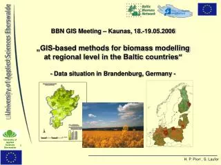
BBN GIS Meeting – Kaunas, 18.-19.05.2006„GIS-based methods for biomass modelling at regional level in the Baltic countries“- Data situation in Brandenburg, Germany -
Suitable spatial data sets(digital) in Brandenburg: • Administrative units: NUTS 1-4 • Topographic base maps: ATKIS data sets (relief, water bodies, land cover, urban area, infrastructure, admin. units ...) • Meteorological data: annual precipitation • Relief: Digital terrain model map set • Soil data: general soil maps, yield index (2), soil types of the EU • Land utilisation data: CORINE and ATKIS • Agriculture: digital field register • Forestry: forest stand maps
Examples of available maps • Aministrative units: • Topographic base maps: • Complex map set with various contents/covers (2005) e.g.: • Relief • water bodies • Land cover • Urban area • Infrastructure • Admin. Units • ...
Meteorological data: • 2003 • 1 km raster • Annual average percipitation • Digital terrain model map sets: • 2004, 25m raster • Developed through digitalised contour lines (10m, 5m, 2,5m, 1,25m), peaks and orthophotos
General soil map: • 2004 • Soil classes and types • Aquifer system • Exchange capacity • Yield index • Yield index maps: • Soil evaluation system with 1-100 point scale • Combination of soil and climatic conditions • Digitised Maps of arable land with corresponding yield index (fields + grassland) • 1st: Yield index „Ackerzahlen“ east Germany (1995) • 2nd: Yield index „Ertragsmesszahl“: analog map of soil quality west Germany (1958) • Digitised and combined by University of applied sciences Eberswalde! (2003) Current map 0 - 10 11 - 20 21 - 30 31 - 40 41 - 50 51 - 60 61 - 70 71 - 80 81 - 90 91 - 100 1:2.000.000 1) Ackerzahl 2) Ertragsmesszahl
Soil types of the EU: • Owned by the EEA • Digitised during CORINE project 2000 for western Europe • updated version with central and eastern Europe already exists in the European soil bureau Ispra • CORINE land cover: • Developed in 2000 • land cover / utilisation information • 4 main classes: • Artificial surfaces • Agricultural areas • Forests and semi natural areas • wetlands
2. Suitable statistical data sources in Germany: • Federal statistics • county, state, national level • National forest inventory • Forestry data base (Eastern Germany) • FSS – EU farm structure survey • Eurostat – New Cronos • Eurostat – Eionet
Most important data sources for agriculture: Federal statistics • acreages, yields and total amounts for all crops available • Annually for whole Germany and the federal states (Brandenburg) • But only in a 4 year cycle for counties (NUTS 3) • No access to municipal data confidential! • Most important data sources for Forestry in Brandenburg: Forestry data base of eastern Germany • Very detailed database for every forest stand in Brandenburg • Automatic update • Since 1990 only reliable for state forest because the additional manual update was only performed for state forests
3. Possible cases: • Regional straw potential for a possible ethanol plant in Schwedt, using 800.000 tonnes of straw per year • Wood chip fuelled CHP Plant in Rheinsberg regional potential of forest residues for a sustainable supply from the region • Suitable areas in Brandenburg for short rotation coppice on set aside farmland • ....