Download
1 / 27
270 likes | 272 Vues
Explore the annual average wind speeds in Texas cities and learn about the diverse ecoregions, landforms, and climate patterns in different parts of the state.

E N D
a. Amarillo b. Austin c. Corpus Christi d. Houston e. Galveston f. San Angelo g. El Paso h. Lubbock
Record the annual average wind speeds for the cities listed below. a. Amarillo 21.7 km/h (13.5 mph) b. Austin 14.3 km/h (8.9 mph) c. Corpus Christi 19.3 km/h (12.0 mph) d. Houston 12.2 km/h (7.6 mph) e. Galveston 17.7 km/h (11.0 mph) f. San Angelo 16.6 km/h (10.3 mph) g. El Paso 14.2 km/h (8.8 mph) h. Lubbock 20.0 km/h (12.4 mph)
Which feature on the list can be found and observed in Texas? a. Deserts b. Canyons c. Mountains d. Beaches e. Meadows of wildflowers f. Swamps g. Pine forests
a. Deserts —Chihuahuan Desert • b. Canyons—Palo Duro Canyon • c. Mountains—Guadalupe Mountains • d. Beaches—Galveston Beach • e. Meadows of wildflowers—Hill Country/Central Texas • f. Swamps—Daisetta Swamp, Liberty County • g. Pine forests—Big Thicket National Preserve
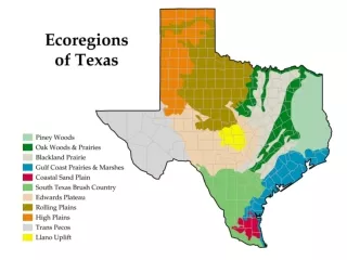
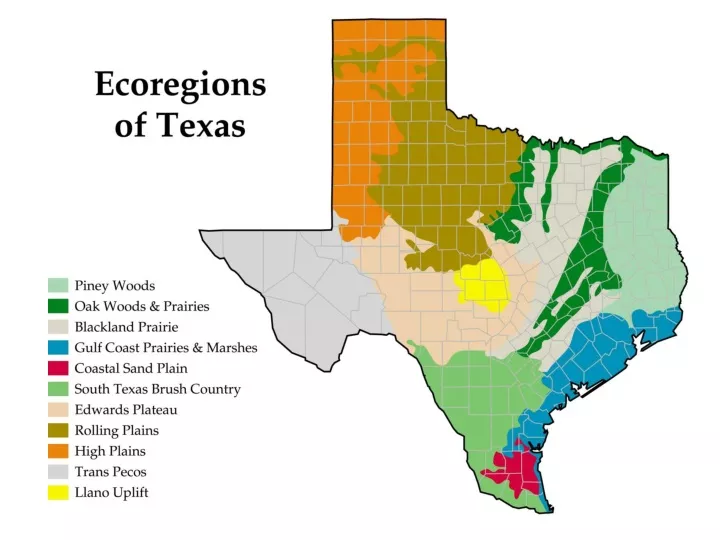
What is the title of this map? What two words are joined together to create the word ecoregion? (ecological + region = ecoregion) What is the root word for ecological? (ecology) What does ecology mean? (Ecology is the study of the environment. This includes the study of the interactions of living organisms with their natural environment.)
What does region mean? (A region is an area of land.) What does ecoregion means? (the study of the environment of a particular area of land) How many ecoregions are shown on this map?
A. Locate the Piney Woods ecoregion on the map. Color the area green and label the ecoregion. B. Repeat the step for the Gulf Coast Prairies and Marshes (blue), the Edwards Plateau(tan),Llano Uplift (yellow), the High Plains (orange), and the Trans Pecos(grey),etc. until you have completed coloring the map and key. Use the next slide to help you.
Look at the next two maps and identify patterns. Be prepared to share what you notice.
Which part of Texas is coldest in January? Which part of Texas is warmest in January?
Which part of Texas is coolest in July? Which part of Texas is hottest in July? Which part of Texas has the biggest changes in temperature from season to season? Which part of Texas has the least change in temperature from season to season? Record information.
What does Precipitation mean? What patterns of precipitation does this map show?
Do all the ecoregions receive the same amount of precipitation? Justify your answer. Why is East Texas shaded green and West Texas shaded brown?
Satellite Map of Texas Showing Evidence of Plant Growth Why is East Texas shaded green and West Texas shaded brown? Why is central Texas shaded yellow? Which two ecoregions generally receive the most rainfall? Which two ecoregions generally receive the least rainfall?
Which two ecoregions generally receive the most amount of precipitation? Which two regions generally receive the least amount of precipitation?
How does precipitation affect soil? How does precipitation affect plants? What is the role(s) of plants in a particular environment? (hold soil in place to prevent erosion, provide food for animals, shelter/habitat)
What are some characteristics of the Piney Woods ecoregion? (tall pine trees, swamp, maple trees, sandy soil, shrubs, broad-leaved plants, grasses, etc.) What are some characteristics of the Gulf Coast Plains and Marshes/Coastal Sand Plains ecoregions? (barrier islands, marshes, flat plains, grasses, etc.)
The pink area centered below represents the igneous rock Granite that is found in the Llano Uplift.
What are some characteristics of the Edwards Plateau/Llano Uplift ecoregion? (Enchanted Rock—a dome of granite, canyonlands, streams, deciduous forests, etc.) What are some characteristics of the High Plains ecoregion? (hills, mountains, short grasses, not as many trees) What are some characteristics of the Trans Pecos ecoregion? (mountain ranges, desert, desert valleys, cactus, etc.)