Download
1 / 15
150 likes | 269 Vues
Java OceanAtlas A Cross-Platform Application for Visualization and Selection of Oceanographic Profile Data. John R. Osborne. http://odf.ucsd.edu/joa/ ftp://odf.ucsd.edu/pub/OceanAtlas/ http://www.pmel.noaa.gov/epic/software/JavaJOA.htm. Java OceanAtlas Architecture. Java OceanAtlas. NdEdit.

E N D
Java OceanAtlasA Cross-Platform Application for Visualization and Selection of Oceanographic Profile Data John R. Osborne http://odf.ucsd.edu/joa/ftp://odf.ucsd.edu/pub/OceanAtlas/http://www.pmel.noaa.gov/epic/software/JavaJOA.htm
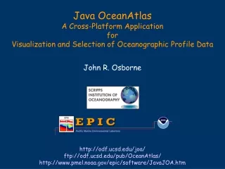
Java OceanAtlas Architecture Java OceanAtlas NdEdit Translation Layer PMEL Java Libraries EPIC System Library (EPS) WOCE Section WOCE CTD EPIC/ WOCE NetCDF EPIC Pointer ZIP Archives POA/JOA Binary TSV SD2 EPIC Pointer Save in these types
Overview of JOA Features • Cross Platform • Windows, Solaris, Mac OS 9/X, Linux
Overview of JOA Features • Sophisticated exploration of profile data • Linked browsing between all plot types • User interface is friendly, but offers many options • Color as a third variable • All plots resizeable and zoomable • No limit on number of open windows • Informative default interface • Full user customization • Includes NdEdit for data selection from large data collections • Large number of supported profile data formats for bottle and CTD data
Overview of JOA Features • Property-Property Plots • Property-property plots with up to 3 x-axes • Isopycnal overlay
Overview of JOA Features • Profile Plots • Offset property-property profiles (waterfall plots)
Overview of JOA Features • Contour Plots • Contoured sections (e.g., depth sections) • Referenced and residual contour plots
Overview of JOA Features • Map Plots • Multiple projections • Station symbols colored by properties interpolated onto multiple surfaces (e.g., pressure or density) • Bathymetry display: isobaths, ETOPO, Sandwell-Smith • Tools to create custom sections
Overview of JOA Features • Customization • Color bars • Color palettes • Interpolation surfaces • Custom coastlines and bathymetry • Saved map settings • CTD Decimation • Fixed levels, JOA surface levels, or custom levels • Sophisticated import of WOCE “Exchange” files • Calculations • Observation Calculations • Simple Custom Calculations • Transformations • Station Calculations • Filters • Station Filters • Observation Filters
NdEdit Unique Interactive Java Tool For In-situ Data Linked windows show xy, xt, zx views of data locations, filter or select with box, polygon or segmented line tools http://www.epic.noaa.gov/talks/oz/ams2002/http://www.epic.noaa.gov/epic/software/JavaNdedit.htm
NdEdit • Java tool • Platform independent • Java Bean architecture allows integration with other tools • Linked windows • Choice of 2D views: latitude-longitude (map), latitude-depth, latitude-time, longitude-depth, longitude-time, and depth-time • Interactive with zoom • Map Features • Overlay bathymetry • Overlay coastlines • Filter or subset data • Browse time-space distribution of in-situ data • Filter in any 2D view • Time or space (lat, lon, z) filters • Remove or retain stations in filter region • Selection Tools • Box • Polygon • Multi-segment section line with user-settable width • Single station selection • Non-contiguous selections • Tools work in all 2D views
Integrating JOA/NdEdit With DODS • NdEdit First Step • Local DODS pointer files: paths replaced by URLs • DODS-driven features in NdEdit • - Interact with DODS catalogs to create pointer files on the fly • JOA First Step • Access netCDF profiles over the internet by supporting http features of netCDF2 • DODS-driven features in JOA • Comparison of local data sets with online resources • Extract sections from n-dimensional datasets
Java OceanAtlas Architecture Java OceanAtlas NdEdit Translation Layer PMEL Java Libraries EPIC System Library (EPS) WOCE Section WOCE CTD EPIC/ WOCE NetCDF EPIC Pointer ZIP Archives POA/JOA Binary TSV SD2 EPIC Pointer Save in these types
Java OceanAtlas Architecture Java OceanAtlas NdEdit Translation Layer PMEL Java Libraries EPIC System Library (EPS) EPIC Pointer WOCE Section WOCE CTD EPIC/ WOCE NetCDF EPIC Pointer ZIP Archives POA/JOA Binary TSV SD2 DODS Pointer DODS