Download
1 / 47
470 likes | 615 Vues
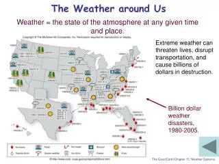
The Weather around Us. Weather = the state of the atmosphere at any given time and place. Extreme weather can threaten lives, disrupt transportation, and cause billions of dollars in destruction. Billion dollar weather disasters, 1980-2005. The Good Earth/Chapter 15: Weather Systems.

E N D
The Weather around Us Weather = the state of the atmosphere at any given time and place. Extreme weather can threaten lives, disrupt transportation, and cause billions of dollars in destruction. Billion dollar weather disasters, 1980-2005. The Good Earth/Chapter 15: Weather Systems
The Atmosphere Checkpoint 14.2 When would oxygen have started to accumulate in the atmosphere if the early Earth had fewer land masses?a)Before 2.5 billion years agob) After 2.5 billion years agoc) 2.5 billion years ago (no change) The Good Earth/Chapter 14: The Atmosphere
The Weather around Us On average, 2-3 U.S. weather disasters per year cause more than a billion dollars in damage and threaten numerous lives. Today, more than 100 million residents make the South the most heavily populated region in the U.S. People are migrating to Florida, Georgia, and N.C. more than any other state. Most people are migrating from states that have low incidences of extreme weather events (New York, Illinois, New Jersey). Would you want to be riding in one of these vehicles? The Good Earth/Chapter 15: Weather Systems
The Weather around Us • Almost 3 times as many people die from extreme temperatures than any other weather related causes. • More than 26,000 people in Europe died in 2003 during hottest summer on record there (104°F or more). • Extreme weather events can change these statistics (e.g. Katrina killed over 1,000 people) • Extreme heat – “…underrated and least understood of the deadly weather phenomena.” Weather-related fatalities. The Good Earth/Chapter 15: Weather Systems
The Weather around Us • Can extreme heat, tornadoes, hurricanes, and other weather phenomena be stopped? • No, but meteorologists work to provide timely warnings. • Hurricane Katrina – most expensive disaster in U.S. history. • Over $100 billion in damage. Hurricane Katrina approaches the Louisiana coast, August 28, 2005. The Good Earth/Chapter 15: Weather Systems
Mid-latitude Cyclones and Frontal Systems • A midlatitude cyclone • At the point where a low-pressure system (cyclone) interacts with neighboring high-pressure systems, a midlatitude cyclone forms. It is centered over the low-pressure system and is characterized by warm (red) and cold (blue) fronts. Cloud cover concentrates over the fronts and low-pressure center. • Classic comma-shaped cloud pattern associated with midlatitude cyclones. Central U.S., Christmas Eve, 1997. The Good Earth/Chapter 15: Weather Systems
Mid-latitude Cyclones and Frontal Systems The boundary between one air mass and another is a front. Frontal systems – pairs of relatively narrow, long, slightly curved regions where air masses interact. Frontal systems bring clouds and precipitation and changes in moisture, temperature, pressure, and wind direction. When warm and cold fronts merge, they form an occluded front. Weather patterns typically associated with a cyclone (low-pressure system) over the central U.S. The Good Earth/Chapter 15: Weather Systems
Mid-latitude Cyclones and Frontal Systems • Advancing Warm Fronts: • Weather changes are not as severe • -Thewarm air does not rise as rapidly • Warm fronts slope gently • Warm fronts move more slowly and the associated rain may last longer than with a cold front • Warm fronts extend over a larger area • Temperatures and humidity rise • Winds change direction Occluded front. A cold air mass overtakes a warm air mass. Nimbostratus clouds generate precipitation along an occluded front. The Good Earth/Chapter 15: Weather Systems
Severe Weather: Thunderstorms and Tornadoes Severe weather (as defined by NWS) has one or more of the following elements: A tornado Damaging wind speeds (more than 58 mph) Penny sized or larger hail Only 10% of all the 100,000 thunderstorms that form over the U.S. each year have these conditions. Most thunderstorms are around 16 miles across and last less than 30 minutes. The Good Earth/Chapter 15: Weather Systems
Severe Weather: Thunderstorms and Tornadoes Moisture in the atmosphere + warm air + a lifting mechanism = a thunderstorm! The life cycle of a thunderstorm. The Good Earth/Chapter 15: Weather Systems
Severe Weather: Thunderstorms and Tornadoes Lightening! Lightening joins two centers of opposite charge associated with a thunderstorm. Cloud to ground lightening – negative charges in a cloud are connected to positive charges on the ground. Cloud to cloud lightening – opposite charges in one or more cloud are connected. The Good Earth/Chapter 15: Weather Systems
Severe Weather: Thunderstorms and Tornadoes Thunderstorms can occur anywhere in the U.S. but their causes vary by region: Central or eastern portion of the states – isolated afternoon thunderstorms in warm summer months when moist air rises. They are typically brief and associated with a single large cloud called a cell. Warm land surface heats the overlying air, causing it to rise, condense, and generate a thunderstorm. Eastern U.S. – thunderstorms associated with midlatitude cyclones. Severe storms from a series of cumulonimbus clouds called supercells. They are associated with frontal lifting along a cold front between cP and mT air masses. Most common during spring and early summer. Rocky Mountains – related to orographic lifting. Florida – warm maritime air rises due to several lifting mechanisms. Thunderstorms are rare in Pacific coast states because weather is influenced by cool ocean more stable air. The Good Earth/Chapter 15: Weather Systems
Weather Systems Checkpoint 15.14 Updrafts responsible for the formation of thunderstorm clouds are most likely to occur with which combination of conditions? • Low-level warm, moist air; upper-level warm, moist air • Low-level cool, dry air; upper-level warm, moist air • Low-level warm, moist air; upper-level cool, dry air • Low-level cool, dry air; upper-level cool, dry air The Good Earth/Chapter 15: Weather Systems
Weather Systems Checkpoint 15.16 Rank the three thunderstorm components (air temperature, moisture, a lifting mechanism) in order of their significance in causing thunderstorms. Justify your ranking. The Good Earth/Chapter 15: Weather Systems
Bow Echo • Notice the big bow in this squall line? It's called a bow echo and the white arrow is pointing to the area that is likely going to get very high winds. This is an extreme case and if you see this approaching your location, very high winds are likely.
Hook Echo • http://blogs.agu.org/wildwildscience/category/radar/
Severe Weather: Thunderstorms and Tornadoes Tornadoes = narrow, funnel-shaped spirals of rapidly converging and rotating air that form in association with thunderstorms. Near-circular low-pressure systems that rotate counterclockwise in the Northern Hemisphere Pressure gradient is much more intense for tornadoes Tornadoes generate the strongest natural winds on Earth! People have been “storm chasing” for about 50 years. Tourists pay companies to get them into tornado prone areas to get footage of tornadoes. Groups of tourists will pile out of minivans and cheer as a tornado rips apart a farmhouse. Is this sensible? The Good Earth/Chapter 15: Weather Systems
Severe Weather: Thunderstorms and Tornadoes The worst tornado outbreak in U.S. history – April 3, 1974. Tornadoes were spotted from Canadian border all the way down to Gulf coast, and from Illinois to Virginia. A total of 148 tornadoes touched down in 13 states. 330 people killed, over 5,000 injured. A massive single tornado threw two tractor-trailers onto the roof of a bowling alley in Xenia, OH as the storm sped through at 50 mph. 33 people killed, 1300 buildings destroyed in Xenia that day. http://www.weather.com/outlook/weather-news/news/articles/tornado-superoutbreak_2011-10-26 The Good Earth/Chapter 15: Weather Systems
Severe Weather: Thunderstorms and Tornadoes • Union City, OK tornado May 1974. • Early stage • Mature stage The Good Earth/Chapter 15: Weather Systems
Severe Weather: Thunderstorms and Tornadoes Tornadoes are ranked on the Fujita intensity scale, which places them in a category based on the destruction they cause. Rule of thumb: Weak tornadoes can tear shingles off the roof of a house, strong tornadoes can tear the roof off a house, and violent tornadoes can tear up the whole house. The Good Earth/Chapter 15: Weather Systems
Severe Weather: Thunderstorms and Tornadoes • Characteristics of tornadoes: • Funnels are less than 2,000 feet wide • Average funnel velocities are 31 mph, with highs of 125 mph • Path of destruction typically 3-16 miles long • Some may stay on ground for over an hour and travel over 62 miles Tornadoes follow the path of their parent thunderstorms (most travel east or northeast, as they are often associated with midlatitude cyclone thunderstorms. The Good Earth/Chapter 15: Weather Systems
Severe Weather: Thunderstorms and Tornadoes a. Early stage. Friction slows winds near surface. Higher wind velocity moving upward from the surface. Contrasting vertical wind speed generates counterclockwise winds about a central horizontal axis. The Good Earth/Chapter 15: Weather Systems
Severe Weather: Thunderstorms and Tornadoes b. Updraft stage. Updrafts below a thunderstorm draw spiraling horizontal winds upward to form a mesocyclone within the larger storm cloud. These are rotating thunderstorms that can be seen on radar (up to 6 miles across). The Good Earth/Chapter 15: Weather Systems
Severe Weather: Thunderstorms and Tornadoes c. Tornado stage. Rotation in the mesocyclone forms small intense spiraling winds within a newly formed tornado. These winds then extend downward from a cloud base toward the ground surface. The Good Earth/Chapter 15: Weather Systems
Severe Weather: Thunderstorms and Tornadoes Why do you think U.S. tornado fatalities have declined in the past 50 or so years? Better forecasting and warnings. The Good Earth/Chapter 15: Weather Systems
Severe Weather: Thunderstorms and Tornadoes Tornadoes occur when thunderstorm activity is at an optimum across much of the nation. More common in Gulf coast and SE states in early spring, migrates to Great Plains in late spring. Tornado Alley. The U.S. is home to the majority of the world’s tornadoes, averaging about 1200 per year. These states have an annual average of more than 5 strong to violent tornadoes, 1950-1995. The Good Earth/Chapter 15: Weather Systems
Weather Systems Checkpoint 15.20 Explain why the number of tornadoes counted each year has increased, while the number of days with at least one tornado sighting has remained essentially unchanged for several decades. The Good Earth/Chapter 15: Weather Systems
Severe Weather: Hurricanes Hurricane Katrina was the worst natural disaster to strike the United States in the last century. Are we doomed to repeat history? Can a hurricane strike the same place twice? More than 1,300 people died An estimated $100 billion in damage in communities in Louisiana, Mississippi, and Alabama Much of the damage had long been predicted – A dozen major hurricanes had made landfall along coastal Louisiana in the last century Government reports, scientific articles, and newspaper stories had all predicted what would happen if a major hurricane made landfall near New Orleans The Good Earth/Chapter 15: Weather Systems
Severe Weather: Hurricanes Who should address the issue? Scientists – best equipped to determine the probability and destruction of a hurricane, but no funds or resources to do much about it. Government – have power and funds for levees or evacuation plans, but don’t always understand the seriousness of the threat. “We learn from history that we learn nothing from history.” George Bernard Shaw Blue areas = flooded areas New Orleans before and after Katrina. The Good Earth/Chapter 15: Weather Systems
Severe Weather: Hurricanes Key observations of Katrina: Large size Dense mass of clouds surrounding central clear “eye” Swirling spiral pattern of clouds Centered over the ocean (Gulf of Mexico) The Good Earth/Chapter 15: Weather Systems
Severe Weather: Hurricanes Hurricanes originate in areas of the world’s oceans where the temperature is greater than about 80°F. Hurricanes are most common in the summer seasons of each hemisphere. The Good Earth/Chapter 15: Weather Systems
Severe Weather: Hurricanes How would you use these data if you worked for an insurance company? How about a construction company? The Good Earth/Chapter 15: Weather Systems
Severe Weather: Hurricanes What are hurricanes: High winds Heavy rainfall Storm surges (elevated water levels) along coastlines Not all hurricanes make land fall Biloxi, Mississippi before and after Katrina. The Good Earth/Chapter 15: Weather Systems
Severe Weather: Hurricanes The Good Earth/Chapter 15: Weather Systems
Severe Weather: Hurricanes North Atlantic hurricane season June 1 – November 30 Hurricanes only develop over warm (>80°F) water down to ~200 ft Needs sufficient evaporation and condensation to foster large volume of moisture to foster growth of huge cloud masses Warm surface waters move north from equator in the summer in N. Hemisphere creating optimal hurricane conditions Development of Atlantic hurricanes that make landfall: 2-3 weeks prior to landfall – Cloud mass develops over warm ocean water. Most storms generated in east Atlantic take about 3 weeks to reach the coast of N. America Katrina – developed in west Atlantic near the Bahamas. The Good Earth/Chapter 15: Weather Systems
Severe Weather: Hurricanes The Good Earth/Chapter 15: Weather Systems
Severe Weather: Hurricanes Hurricanes begin to grow when warm, humid air is forced aloft. The rising air cools and condenses to form cumulus clouds that will develop into cumulonimbus cells. Earth’s rotation imparts a counterclockwise rotation to the storm in the Northern Hemisphere. This rotation is zero at the equator, therefore the majority of hurricanes originate between 10° and 20° N or S of the equator. To maintain wind speed, inflow of air into developing low-pressure system must be matched by outflow of air in the upper troposphere. The Good Earth/Chapter 15: Weather Systems
Severe Weather: Hurricanes 1-2 weeks prior to landfall – Tropical depression develops (winds 23-39 mph). After about 5 days this develops into a tropical storm (winds 39-74 mph). Finally, a hurricane develops (winds at least 119 mph). Air pressure is lowest in the eye, where warm air is rising. The lower the pressure inside the hurricane, the faster the winds. Hurricanes will continue to grow in size and intensity as long as underlying water temperature remains above 80°F. Precipitation concentrates within 124 miles on either side of eye, releasing up to 20 billion tons of water per day. The Good Earth/Chapter 15: Weather Systems
Severe Weather: Hurricanes 3-7 days before landfall – Atlantic hurricanes are driven west by prevailing winds at 6-16 mph. Florida and Texas experience more landfalls than any other state. Hurricane may turn parallel to the east coast or pass south of Florida to strike the Gulf Coast or Caribbean islands. 2-3 days before landfall – The likely landfall site is identified. Evacuations should be in full gear by now. 1-2 days before landfall – Size and slow motion of hurricanes means their impact is drawn out over several days. Effects can reach coast before worst affects from the eye. Measurements are made off coast by buoys to gather info about eye Waves over 100 feet high during Katrina Predicted landfall site of Katrina. It hit within 19 miles of the predicted site. The Good Earth/Chapter 15: Weather Systems
Severe Weather: Hurricanes Winds in the NE quadrant blow onshore, piling up water in a storm surge. Surges cause ~90% of the damage in coastal areas. Can potentially reach inland areas up to 6-12 miles from shore. Katrina – water reached heights of 30 feet above sea level in NE quadrant of storm. Winds in NW quadrant blow offshore. In the case of Katrina, winds in NW quadrant pushed water from Lake Pontchartrain (located NW of the city) over levees into the city. The Good Earth/Chapter 15: Weather Systems
Severe Weather: Hurricanes Hurricanes can take days to make their way onshore. Hurricanes lose intensity over land because of frictional drag and loss of a moisture source. Damaging winds near the core have speeds similar to F1-F3 tornadoes. Can rain up to 24 inches of rain in just a few days over inland regions. Water causes major erosion and damage from flooding. Erosion from hurricane Ivan eroded most of N segment of Chandeleur islands, LA. In box – lighthouse. The Good Earth/Chapter 15: Weather Systems
Severe Weather: Hurricanes Katrina – category 3 hurricane In 1973 in Bangladesh – Cyclone pushed onshore from Bay of Bengal 22-foot storm surge produced widespread flooding on the low lying plain 300,000 deaths The Good Earth/Chapter 15: Weather Systems