Development of an Autonomous UAV for Aerial Photography at GPS Waypoints
40 likes | 158 Vues
This project focuses on designing an Unmanned Aerial Vehicle (UAV) that can autonomously navigate to specified GPS waypoints, capture images with an onboard camera, and return to its base. Key challenges included maintaining flight stability with the additional weight of the camera and equipment, balancing the UAV, and optimizing the PCB size. Additionally, we addressed concerns related to GPS sensitivity and RF interference, while implementing robust software control algorithms. The successful demo showcased the UAV's capabilities in real-time navigation and image capture.

Development of an Autonomous UAV for Aerial Photography at GPS Waypoints
E N D
Presentation Transcript
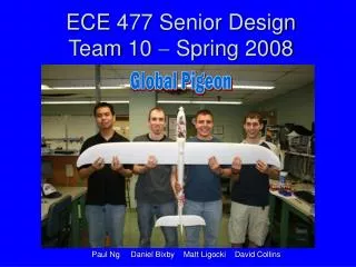
Global Pigeon ECE 477 Senior DesignTeam 10 Spring 2008 Paul Ng Daniel Bixby Matt Ligocki David Collins
Project Overview • To make an Unmanned Aerial Vehicle capable of taking pictures at GPS waypoints. • Able to fly to GPS waypoints and back to base successfully. • Must be able to take pictures using the onboard camera. • Must be able read and write coordinates from an onboard microSD card.
Design Challenges Faced • Keeping plane aloft with additional weight • Keeping plane balanced • Minimizing PCB area to fit in plane • GPS sensitivity • RF interference • Software control algorithms