Cape Cod
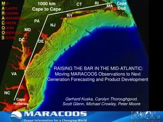
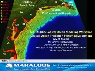
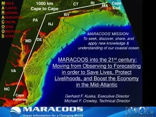
M iddle A tlantic R egional A ssociation C oastal O cean O bserving S ystem. 1000 km Cape to Cape. RI. Cape Cod. CT. MA. NY. PA. NJ. MARACOOS’ MISSION: To seek, discover, share, and a pply new knowledge & u nderstanding of our coastal ocean. DE. MD.

Cape Cod
E N D
Presentation Transcript
Middle Atlantic Regional Association Coastal Ocean Observing System 1000 km Cape to Cape RI Cape Cod CT MA NY PA NJ MARACOOS’ MISSION: To seek, discover, share, and apply new knowledge & understanding of our coastal ocean DE MD MARACOOS into the 21st century: Moving from Observing to Forecasting in order to Save Lives, Protect Livelihoods, and Boost the Economy in the Mid-Atlantic VA NC Cape Hatteras Gerhard F. Kuska, Executive Director Michael F. Crowley, Technical Director
MID-ATLANTIC REGIONAL DRIVERS Tropical Storms Climate Change Ocean Circulation Critical Habitat Northeasters Population Ports
Mid-Atlantic Regional Association Coastal Ocean Observing System Established 2007: 35 Co-PIs, 25 Institutions, 10 States (&DC), 111 Congr.districts • Sustained regional observing networks are established • Societal priorities drive development • MARACOOS supports the R&D continuum throughout the region
MARACOOS REGIONAL THEMES & SUCCESS STORIES 1) Maritime Operations – Safety at Sea 3) Water Quality – a) Floatables, b) Hypoxia, c) Nutrients 5) Energy – Offshore Wind 2) Ecosystem Decision Support - Fisheries 4) Coastal Inundation - Flooding
Maritime Safety: U.S. Coast Guard Search and Rescue example Mid-Atlantic Operational Data Flow to SAROPS SAROPS User Interface SAROPS 96-Hour Search Area:HF Radar= 12,000 km2 SAROPS 96-Hour Search Area: HYCOM = 36,000 km2
Ecological Decision Support – Fisheries + Like Upwelling Our Approach: Develop statistical models using bottom trawl surveys and MARACOOS 3-D data to predict species distribution based on observed or forecasted MARACOOS 3-D fields. Hate Downwelling Downwelling Upwelling Downwelling Upwelling
Water Quality Data and Modeling to respond to 120+ million gallons of sewage released into the Hudson River following North River Wastewater Treatment Plant fire in NYC, July 2011
Coastal Inundation Chesapeake Inundation Prediction System (CIPS) Partners From Forecast • MATURING TECHNOLOGY • Regional scale atmospheric wind forecast model • Very high-resolution hydrodynamic models with land flooding • Very high-resolution land elevation data (LIDAR) • Emerging GIS and visualization capabilities for integrated, high-resolution pictures and products To Impact Bridging the Gap
Offshore Wind Energy High Resolution Atmospheric Forecast validated with HF radar Additional Radar Sites Spatial validation of Atmospheric Model with 13 MHz Multi-static HF Radar Array 2-Site Mono-static Coverage High Resolution Wind Resource 670 mhorizontal resolution Bi-static Geometries 2-Site Multi-static Coverage
The Next Decade • Building out the system (10-year BOP) (www.maracoos.org, see technology tab) 2. Engaging the Stakeholders - Product Developmentsupported by R&D 3. Education andCommunications
Engaging the Stakeholders • Governance Structure • User Council • Working Groups • Stakeholder Liaison Service (Geographic and Theme-focused) User Council Inund-ation EDS: Fish Water Quality Wind Energy Marine Safety
Improved Predictive Modeling and Data Assimilation 1) STPS U. Connecticut 4) HOPS U. Massachusetts, Dartmouth 2) NYHOPS Stevens Institute of Technology 3) ROMS Rutgers University
Enhancing Platforms and Observing Capabilities L-Band (installed 1992) X-Band (installed 2003) Satellites Autonomous Underwater Gliders Drifters HF Radar Ships
Education vs. Communications • Not the same thing; need to distinguish • Communication / Outreach: • Stakeholders, Decision makers, Funders • Developing and selling our products/services • Education: • Informal Educators, K-12, Community College/2-yr programs, Undergrad/4-yr, Graduate, Workforce • Using real time data in the classroom
THANK YOU www.maracoos.orgwww.usnfra.org