Download
1 / 54
570 likes | 993 Vues
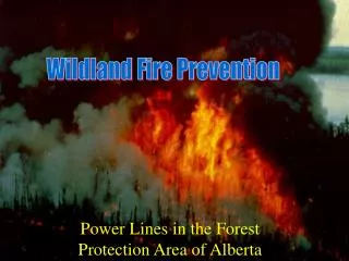
Fire-growth models: a multi-scale toolkit for wildland fire management in Canada. Bruce Macnab Head, Wildland Fire Information Systems Kerry Anderson Fire Research Scientist Marc-Andre Parisien Fire Research Scientist Northern Forestry Centre Edmonton, Alberta. Presentation Outline.

E N D
Fire-growth models: a multi-scale toolkit for wildlandfire management in Canada Bruce Macnab Head, Wildland Fire Information Systems Kerry Anderson Fire Research Scientist Marc-Andre Parisien Fire Research Scientist Northern Forestry Centre Edmonton, Alberta
Presentation Outline • Bruce Macnab • Introduction • CWFIS • Kerry Anderson • Marc-Andre Parisien
Canadian Wildland Fire Information System (CWFIS) and Fire Research at NoFC • Putting new knowledge, tools into practice • A brief overview of wildland fire in Canada and the CWFIS • Kerry : examples of multi-scale fire growth models • Marc: Burn Probability mapping Wildland Fire in Canada
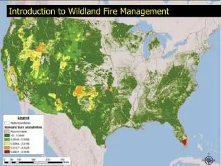
Wildland Fire in Canada • 2.1 million ha burned annually by 8000 fires • >95% of area is burned by <5% of fires (mostly lightning fires) • Dominated by large, stand replacing fires • Lightning causes ~50% of all fires (but ~85% of area burned)
Fire Management in Canada Forest fires are a major issue to: • Safety and security of Canadians (e.g. BC 2003, AB 2011) • Economic impacts (e.g. timber supply) • Environmental (e.g. natural process, Carbon emissions) Key legal and policy consideration: • Forests a provincial/territorial jurisdiction • More focused federal priorities
Economic Social Environmental Canadian Wildland Fire Information System, Understanding the Effects of Climate Change on Wildland Fire, Assessing Wildland Fire Impacts on the Canadian Forest and Wildland Urban Interface, Enhancing the Canadian Forest Fire Danger Rating System Federal Role in Canadian Forest Fire: Present NRCan/CFS role in Forest Fire: Current priorities
Fire doesn’t respect borders Fire is dynamic over space and time Most fire seasons: significant fire events in at least one region Fire management in Canada hinges on successful collaboration for information, tools, fire suppression resources Wildland Fire in Canada
Provincial/Territorial Collaborators National International
What is the CWFIS? A web-based fire information system that monitors forest fire conditions and fire occurrences across Canada.
Canadian Wildland Fire Information System • Displays daily maps and reports of forest fire conditions across Canada • Aids public safety and awareness • Contributes to the development of science and technology
Next Canadian Wildland Fire Information System Fire Growth Modelling Applications Bigfoot Hotspot-based operational fire-growth predictions Pandora Making the Prometheus "fire engine" available to custom applications Burn-P3 Estimating burn probability / susceptibility [web page] [web page] Pegasus Running fire spread simulations over the web PFAS Probabilistic Fire Analysis System [web page]
Presentation Outline • Bruce Macnab • Kerry Anderson • BigFoot • PFAS • Marc-Andre Parisien
Wildland Fire in Canada Often it is a weather event that push a fire from one scale to another, whether it be: • dry conditions that move a smouldering fire to a flaming, detectable fire, • a wind gust that moves a small fire to an escape • long-term drought conditions that move a escape to a campaign fire (often requiring a fire stopping rainfall to put out)
Canadian Wildland Fire Information System BIGFOOT BIGFOOT is a web-based fire-growth model that provides fire managers a first look at potential fire growth. • Hotspot data are used to approximate active fire zones and fire perimeters. • Weather forecasts are included using Environment Canada products. • Prometheus is used to produce the fire growth projections.
BIGFOOT Wildland Fire in Canada
Canadian Wildland Fire Information System BIGFOOT Hotspots as detected by MODIS and NOAA/AVHRR are used to construct fire ignition grids for model runs. Hotspots occurring near communities, and clusters of hotspots in areas of high fire danger are prioritized for modelling.
Canadian Wildland Fire Information System BIGFOOT Forecasted weather data, such as gridded binary (GriB) and SCRIBE products, are received from the Canadian Meteorological Centre. Forecasted conditions are then interpolated to the fire location for fire-growth modelling.
Canadian Wildland Fire Information System BIGFOOT Fuels, elevation, and ignition grids, and forecasted weather data are entered into the Prometheus fire-growth model to provide predictions for the next 24 to 48 hours.
Canadian Wildland Fire Information System BIGFOOT Currently, BIGFOOT predictions are available within the CWFIS Interactive Mapper.
Canadian Wildland Fire Information System Probabilistic Fire Analysis System The Probabilistic Fire Analysis System (PFAS) is a suite of fire-growth models developed to predict the potential size or probable extent of a wildfire if it was allowed to grow unimpeded for the course of the fire season.
PFAS PFAS Wildland Fire in Canada
Current hotspot Old hotspot (now extinguished) 11% 33% 55% 77% 100% Canadian Wildland Fire Information System Probabilistic Fire Analysis System • Short-range • hourly • deterministic • Medium-range • daily • ensemble • Long-range • weekly • probabilistic
Canadian Wildland Fire Information System Probabilistic Fire Analysis System Long-range The models are designed so that they may be run in sequence, with the results of one model initializing the subsequent model run. Medium-range Short-range
Canadian Wildland Fire Information System Probabilistic Fire Analysis System Short-range The short-range model within PFAS is a deterministic, sixteen-point fire growth model that uses hourly weather. The program comes with a robust weather calculator that intuitively reads weather files (ASCII and ODBC), interpolates missing data, calculates diurnal trends, etc.
Canadian Wildland Fire Information System Probabilistic Fire Analysis System Short-range While not as sophisticated as Prometheus, the short-range model within PFAS provides a fast and simple tool for predicting fire behaviour and a platform to develop new applications.
Canadian Wildland Fire Information System Probabilistic Fire Analysis System August Short-range The fire-growth direction can be reversed to find where fires could occur that would reach a target. Multiple runs can provide a method to estimate areas of probable threat to communities. July June
Canadian Wildland Fire Information System Probabilistic Fire Analysis System Medium-range The medium-range model applies the short-range model in an ensemble-like fashion. In this case, pertubations are added to each weather element to create 9 fire predictions (other combinations are possible). [T, H, W, D] [T+T’,H,W,D] [T-T’,H,W,D] [T, H+H’, W, D] [T, H-H’, W, D] [T, H, W+W’, D] [T, H, W-W’, D] [T, H, W, D+D’] [T, H, W, D-D’]
Canadian Wildland Fire Information System Probabilistic Fire Analysis System Medium-range Our goal is to integrate this ensemble approach with the North American Ensemble Forecast System (NAEFS) to provide multi-days predictions of potential fire growth in BIGFOOT.
Canadian Wildland Fire Information System Probabilistic Fire Analysis System Long-range The long-range fire-growth model was developed to predict the potential size or probable extent of a wildfire if it was allowed to grow unimpeded for the course of the fire season. The model combines the probabilities of fire spread and of survival to produce a probable fire extent map.
Canadian Wildland Fire Information System Probabilistic Fire Analysis System Long-range Fuels grids and weather networks are included in the model’s spatial approach. 40% 50% 50% 60% Spread Survival Extents
Canadian Wildland Fire Information System Probabilistic Fire Analysis System BC – 2009, 2010 15 and 30 day projections were made for 37 fires in BC during the 2009 fire season Terrain Fuels 15 day Fire Growth Projection (Prescribed Fire Analysis System) _____Current fire perimeter (approx 76 000 ha) _____15 day area at risk (approx 180 000 ha) (50 % probability) _____30 day area at risk (approx 317 000 ha) (50 % probability) 30 day
Canadian Wildland Fire Information System Probabilistic Fire Analysis System Alberta - 2011 During the 2011 fire season, PFAS was used to predict the potential growth of the Richardson fire.
Canadian Wildland Fire Information System Probabilistic Fire Analysis System Ontario - 2011 During the 2011 fire season, PFAS was used to predict the potential growth of multiple fires in Western Ontario. 30 day
Presentation Outline • Bruce Macnab • Introduction • CWFIS • Kerry Anderson • BigFoot • PFAS • Marc-Andre Parisien • Burn P3
Mapping BP from: • Statistical relationships • Simulation modeling Saskatchewan Evolution of BP mapping Taiga Shield 114 years Boreal Shield 99 years Boreal Plain 263 years • Computing fire cycle from: • Fire observations • Time-since-fire maps; Fire scars
What is Burn-P3? • A windows-based software designed to map fire susceptibility (i.e., burn probability) • A simulation model combining: • The landscape-level factors affecting fire regimes • Fire spread (using Prometheus) • Initially designed for long-term planning of fire management activities
Burn-P3 general design PERIMETER OF THE SIMULATED FIRE Spatial patterns Length of burning period Simulation of fire growth IGNITIONS WEATHER Fire growth with Prometheus Daily fire weather Number of fires “Where, when (season), and how many fires in a given year?” “Under what conditions and for how long does a fire burn?”
C15R8 50 C15R8 = 1000 100 Burn-P3 processes Burn probability = 5% (from Jen Beverly)
Fuel treatment effectiveness Untreated landscape Treated landscape Parisien et al. (2007, Int. J. Wildland Fire)
STEP 1: Build a BP map for WBNP using the full set of inputs • “Control BP” BP modeling in Wood Buffalo National Park • Non-spatial inputs: • Number of fires per “iteration” • Daily fire weather conditions • Duration of burning • Spatial inputs: • Fuels • Topography • Ignition patterns
Original data Randomized fuels Isolating controls on BP Produce BP map BP “Residuals” =
Isolating controls on BP 54% 44% 2%
Burn probability Flame length Burn probability and fire effects (from Ager et al., 2012, For. Ecol. Manage.)