Download
1 / 35
350 likes | 360 Vues
Explore how fire impacts short and long-term vegetation changes in Alaska tundra, implications for wildlife, and potential effects of shrub expansion due to warming. Study past fieldwork data from various tundra sites.

E N D
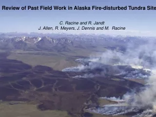
Review of Past Field Work in Alaska Fire-disturbed Tundra Sites C. Racine and R. Jandt J. Allen, R. Meyers, J. Dennis and M. Racine
QUESTIONS • HOW DOES FIRE CHANGE TUNDRA VEGETATION BOTH SHORT (0-1-- AND LONG-TERM (20-35 yrs) • WHAT ARE THE IMPLICATIONS OF THIS VEGETATON CHANGE FOR WILDLIFE AND OTHER PROCESSES? . • WILL SHRUB EXPANSION DUE TO WARMING LEAD TO AN INCREASE IN FIRE AND COULD FIRE ALSO LEAD TO MORE SHRUBS?
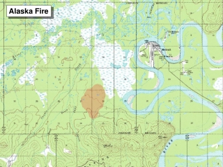
WHERE? ARCTIC SLOPE NOATAK RIVER SELAWICK SEWARD PENINSULA
Noatak Sites Seward P. Sites Anaktuvuk R. Kokolik
Noatak River 115,000 acres Treeline Seward Penin. 238,000 acres Yellow= 1977 Fires
SEWARD PENINSULA IMURUK LAKE- NIMROD HILL 1977 10000 ha Fire 1983 CIR
Seward Peninsula- Nimrod Hill on Imuruk Lake 1978 8 7 7 6 5 4 3 2 1
Severity SEVERE LIGHT LIGHT MODERATE FOOT SLOPE 2-3% 5-7% BACK SLOPE 10-13% CREST 0% Topography 140 8 120 7 100 6 Vertical Distance (M) WET SEDGE BOG TUSSOCK-SHRUB TUNDRA 80 5 DWARF SHRUB TUNDRA 60 4 40 3 2 20 1 0 1000 2000 HORIZONTAL DISTANCE (M)
Monitoring Vegetation Recovery • Began in 1978, one year after 1977 fire. • Had sampled soils and vegetation on this slope in 1973 providing some prefire “control”. • Eight sites spaced equally along transect from bottom to top of Slope, • At each site, 10 1m x 1m plots between rebar. • Visual estimation of plant species cover, density and height in each 1m x 1m plot. • Resampled at about 5-10 year intervals. Last sampled in 2009, 32 years after fire.
SEWARD PENINSULA NIMROD HILL WHOLE SLOPE 1973 1978 1978 2009
Site 3 10 m transect Nimrod Hill Footslope Tussock-Shrub Tundra 1978 (1 year) 1983 (6 years) 2001 (24 years) 2009 (32 years)
NIMROD SITE 5 1980
SITE 2 TUSSOCK TUNDRA SPECIES CHANGES Following 1977 Tundra fire Near Imuruk Lake Central Seward Peninsula. ERIOPHORUM LEDUM RUBUS SPHAGNUM SITE 5 WILLOW LEDUM
WELL-DRAINED TUNDRA- SITE 6 1973 PREFIRE 1978 1 YEAR 1983 6 YEARS SEDGE MEADOW 2009 32 YEARS
NIMROD HILL SITE 7 1983 (5 years) 1979 (2 years) 2001 (24 years) 2009 (32 years)
BURNED WATER TRACK? 1980
Satellite image of a Large (88,630 acres)1999 tundra fire along Noatak River. In Noatak tundra fires mostly at lower elevations along river.
1981 (four yrs postfire) 2005 (28 yrs postfire) 1981 4 years post-fire Dominated by grasses,. Dwarf Shrub tundra before fire.
NOATAK R. Kungiakrok Creek Site burned June 21, 1982 July 5, 1982 3 weeks after fire July 27, 2005 23 years post-fire
1982 2005 Note large increase in birch shrubs and spruce saplings.
Kokolik River Fire 1977 69.5 N 161.8 W 1995 Satellite image 1977
1993 WAINWRIGHT FIRES 1999 IMAGE