Diverse Terrain of South Asia: Landforms, Rivers & Resources
Explore the varied landscape, major river systems, and rich natural resources of South Asia encompassing the subcontinent's distinctive features. Learn about the Himalayas, Ganges River, diverse climates, and key minerals that shape this region's geography and economy. Discover how monsoons impact agriculture and the land's vulnerability to natural disasters.

Diverse Terrain of South Asia: Landforms, Rivers & Resources
E N D
Presentation Transcript
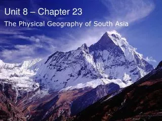
Unit 8 – Chapter 23 The Physical Geography of South Asia Ch 23 PP
I. Section I The Land Ch 23 PP
A. A Separate Land • Subcontinent – a large distinct landmass that is joined to a continent • The seven countries in this region are separated from the rest of Asia by mountains • Most of South Asia is a peninsula Ch 23 PP
B. A Land of Great Variety • The Himalayas • Theory – the force of the collision between the subcontinent & Asia formed these • Mt. Everest – highest peak in the world – located here – 29,035ft. – border of Nepal & China Ch 23 PP
K2 (Godwin Austin) – 2nd highest peak – 28,250ft. – Pakistan Ch 23 PP
A Land of Great Variety (cont.) • Other Northern Landforms • Karakoram Mtns., Hindu Kush • In the past, invaders could only enter through the Khyber Pass • Ganges Plain (or Indo-Gangetic Plain) • 1/10 of the world’s population lives here! Ch 23 PP
B. (cont) • Central Landforms • Vindhya Range – also “pushed-up” by the collision • Divides India into northern & southern regions • Southern Landforms • Eastern & Western Ghats – form a triangle • Between them lies the Deccan Plateau Ch 23 PP
C. Major River Systems • Indus & Brahmaputra Rivers • Indus flows mainly through Pakistan • Empties where? • Brahmaputra flows through the Himalayas and then into India & Bangladesh • Joins with the Ganges to form a delta • Where does the Brahmaputra empty? Brahmaputra – ‘braided’ river Ch 23 PP
Major River Systems (cont.) • Ganges River • Most important river of this region! • Its waters are considered to be sacred • Ganges Plain is considered the world’s largest alluvial plain – India’s most densely populated area! Ch 23 PP Bathing in the Holy waters of the Ganges
D. Natural Resources • Water • Rivers • Alluvial soil, drinking water, transportation, hydroelectric power • Dams • In Pakistan, the Tarbela Dam, one of the largest dams in the world, will soon be unusable! (Built up silt from the Indus) • Energy Resources • Petroleum, natural gas, uranium • Minerals • Leading exporter of iron ore • Mica – layered rock used to make electric equipment (90% of world) - India • Sri Lanka – one of the world’s largest producers of graphite • Timber • Very important to this region! • Economy & Soil Ch 23 PP
II. Section II Climate & Vegetation Ch 23 PP Rampur, India
A. South Asia’s Climates • Tropical & Subtropical Climates • Tropical Rain Forest & Tropical Savanna • Highlands Climate • Northern edge of region • Dry Climates • Great Indian Desert (Thar Desert) • Steppe Ch 23 PP
B. Monsoons • Monsoon Rains • Monsoons – Seasonal Winds • Rains needed for crops • Sometimes they cause floods though! • Natural Disasters • Drought, Floods,Cyclones Ch 23 PP