Download
1 / 44
450 likes | 488 Vues
Learn the significance of soil classification and methods used, such as Soil Taxonomy in the United States. Discover how soil properties are observed and measured for classification, including diagnostic horizons. Explore major soil classification systems worldwide.

E N D
Soil Classification in the United States Soil Morphology, Genesis, and Classification (SPS 350)
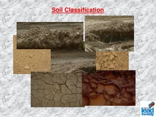
Why classify soils? • Whenever we call things by group names, or give them labels that inform us of their important properties, we are doing classification. • The names or labels could provide information about their appearance, make up, functions or their other known important characteristics • Same applies to soils when we use names like • Black cotton soils • Rice soils • Olive soils • Limestone soils • Piedmont soils • Alluvial soils Suitability for different uses Method of soil formation
Such classification terms may convey some valuable meaning to local users • However, they do not help us to organize our knowledge of soils • or for defining the relationships among different soils • For classification to address these concerns, soils are classified as natural bodies on the basis of their soil profile characteristics • By using a system of classification of soils, we create a universal language of soils that enhances communication among users of soils around the world.
Concept of Individual Soils • This concept recognizes the existence of individual entities each of which we call a soil. • Soil individuals having one or more characteristics in common may be grouped together. • The groups are aggregated into higher-level categories of soils, each having some characteristic that sets them apart from the other. • Therefore broad soil groups are defined as one moves up the classification pyramid
Pedon and Polypedon • There are no sharp demarcations between one soil individual and another. • There is a gradation in soil properties as one moves from one soil individual to an adjacent one. • Soil individuals are characterized in terms of an imaginary three dimensional unit called pedon. • A pedon (1 to 10 m2) is the smallest sampling unit that displays the full range of properties that characterize a particular soil. • The pedon serves as the fundamental unit of soil classification. • A group of similar pedons that are closely associated in the field are called polypedons, and are recognized as soil individuals. • All soil individuals that have in common a suite of soil profile properties and horizons that fall within a particular range are said to be in the same soil series.
Pedon-Polypedon-Landscape Model Hierarchical soil classification groups soils into increasing levels of generality between these two concepts –pedons and polypedons • A soil unit in a landscape consists of a group of very similar pedons (polypedon). • A polypedon is a soil individual. • Soil individuals that have in common a suite of soil profile properties and horizons that fall within a particular range are said to belong to the same soil series.
Major Soil Classification Systems of the World • USSR (Russian) Soil Classification System • Natural Soil System of Kubiena • French Soil Classification System • Belgium Soil Classification • British System of Classification • Soil Classification of Canada • Australian Soil Classification System • Brazilian Soil Classification System • FAO/UNESCO Soil Map of the World • US Soil Taxonomy
The United States Soil Taxonomy • Soil Taxonomy, the official soil classification system of the United States was officially adopted in 1965 • Since then, it has gained recognition as a possible universal system for classifying soils. • However, to date, no system of classification has world wide acceptance • Soil Taxonomy is based on soil properties that can be objectively observed and measured. • Soil Taxonomy makes use of nomenclature which gives definite connotation of the major characteristics of soils
Bases for Soil Classification in Soil Taxonomy • The physical, chemical and mineralogical, and biological properties of soils as they are today, are the basis for classifying soils in the Soil Taxonomy. • E.g. moisture, temperature, color, texture, structure, organic matter, pH, % base saturation, soil depth, etc. are important criteria for classification. • Some of these properties are observed in the field, but others require precise measurements in the lab. • These precise measurements are used to define certain diagnostic soil horizons, the presence or absence of which determine the place of a soil in the classification system.
Diagnostic Horizons • Soil Taxonomy makes use of diagnostic soil horizons for classification. • Diagnostic horizons have specific characteristics that are indicative of certain classes of soils • There are two types of diagnostic horizons • Soil Surface diagnostic horizons (epipedons) • Sub surface diagnostic horizons
Soil surface diagnostic horizons (epipedons) • Mollic epipedon (A) • Umbric (A) • Histic (O) • Ochric (A) • An epipedon is a diagnostic horizon that forms at the surface. • Any horizon may be at the surface of a truncated soil. • There can be only one epipedon for mineral soils. • Melanic • Anthropic (A) • Plaggen (A)
Soil surface diagnostic horizons (epipedons) • Mollic Epipedon • thick, dark, soft, surface layer. Characteristics: Thick - greater than 10 inches, High base saturation, Mineral soil, Soils formed under prairie vegetation • Umbric • like mollic, but low base saturation • Histic • Organic Soil - saturated with water, with more than 20-30% organic matter • Plaggen • surface layer made by humans that is > 50 cm thick that has been produced by manuring. It usually contains artifacts, such as brick and pottery, and spade marks throughout.
Melanic • thick, black horizon that contains high concentrations of OC and short-range-order minerals such as allophane and imogolite. • Anthropic • disturbed by human activity. Meets all of the requirements for a mollic except (A) it has >250 ppm PsO5 soluble in 1% citric acid with or without the base saturation requirements or (B) the duration of available moisture. • Ochric • thin, light colored - surface layers that do not fit any of the above
Argillic (Bt) Natric (Btn) Spodic (Bhs) Oxic (Bo) Cambic (B) Kandic Albic (E) Agric (A or B) Calcic (K) Duripan (m) Fragipan (x) Gypsic (y) Salic (z) Petrocalcic Petrogypsic Placic Sombric Sulfuric Soil subsurface diagnostic horizons Diagnostic subsurface horizons form below the soil surface. Usually, they are B horizons but diagnostic subsurface horizons may include parts of A or E horizons. Some soils do not have a diagnostic subsurface horizon.
Soil subsurface diagnostic horizons • Argillic • contains illuvial clay -Bt • Must contain a significant clay increase. • If eluvial horizon has <15% clay, must have at least a 3% absolute increase (e.g., from 10 to 13%). • Natric • same as argillic but with > 15% exchangeable sodium (Na) • Spodic • illuvial accumulation of oxides of Al and Fe and OM, red or dark red color - only found in acid sandy soils, with high rainfall- generall found below E horizon. Contains a Bhs or Bs horizon subsurface horizons (cont.)
Oxic • very weathered layer of only Fe and Al oxides and 1:1 clay minerals, low pH and not very fertile (found in tropical soils) • Cambic • slightly altered layer - not weathered enough to be argillic, Bw horizon designation or development of color and or structure • Calcic - contains an accumulation of CaCO3 • Has CaCO3 equivalent 15% and contains 5% more CaCO3 equivalent than the C horizon or • Has CaCO3 equivalent 15% and contains 5% identifiable pedogenic CaCO3 forms such as concretions, soft powdery forms, etc.
Kandic • a highly weathered horizon with low cation exchange capacity (CEC). It usually meets all of the classification criteria of an argillic horizon along with the following CEC requirements in 50% or more of its thickness from the top to the Bt to a depth of 100 cm: • CEC < 16 cmol/kg of clay • Effective cation exchange capacity (ECEC) <12 cmol/kg of clay where ECEC = Ca + Mg + K + Na + extractable Al • Fragipan • a "hardpan" that is brittle when moist and very hard when dry. Peds will slake or fracture when placed in water. Very difficult to dig with a spade when dry.
Soil Classification II • Categories of the Soil Taxonomy • Description of the Soil Orders • Key to the Soil Orders • Suborders • Great Groups and Sub Groups • Soil Families • Soil Series
Categories of the Soil Taxonomy • Orders (12) (surface and subsurface diagnostic horizons) • Suborders (55) (Soil temperature. and moisture regimes) • Great group (238) (subsurface diagnostic horizon) • Subgroup (1243) (drainage, lithic contact, PM, clay type) • Family (7504) (Texture of diagnostic surface horizon) • Series (about 19,000) in U.S.
Soil Orders • Every soil in the world is assigned to one of 12 orders that reflect major course of development. • In the orders, there is considerable emphasis placed on the presence or absence of major diagnostic horizons. • Bold letters in the soil order names indicate formative element used as ending for lower taxa.
Degree of weathering and soil development in the different soil orders
1. Entisols -recent • No diagnostic subsurface horizons. • Very recent or young soil • Little if any profile development • Form on • resistant P.M., • mine spoils, • steep slopes, • floodplains
2. Inceptisols inception (Latin, beginning) • Slightly more development than Entisols • Young soils but beginning of profile development is evident. • Well-defined profile characteristics of mature soils are yet to be developed. • May have a cambic horizon
3. Mollisols mollis (Latin, soft) • Typically form under grasslands. • E.g., Central US • Soils with a mollic epipedon: • Thick humus-rich surface horizon • High % base saturation throughout profile • Slightly leached • Very fertile soils
4. Alfisolspedalfer • Do have an argillic horizon • About 35% base saturation • Develop in humid, temperate regions • Vegetation is usually deciduous (forests, savanna) • Gray to brown surface horizon • Good for grain production
5. Spodosols-spodos (Greek, wood ashes) • Have a spodic horizon • Form in humid, cool climates and occur most often in conifer forests (New England, Mich., Canada) • Form in acid, coarse, quartz (sandy) bearing P.M. • Low fertility
6. Ultisols-ultimate (Latin, last) • Have Argillic or Kandic with <35% Base saturation. • Common in S.E. US, humid tropical, and subtropical regions • Warm and humid environs. • Old, highly weathered, high degree of development (ult) • Low fertility
7. Oxisols-oxide (French, oxide) • Have an oxic horizon. • Dominated by residual accumulations of Fe and Al oxides and kaolinite • Most extensively weathered soils (occur in tropical regions). • Intense red or yellow (high in oxidized iron). • Low % Base Saturation. • extensively leached • Low fertility.
8. Histosols-histos (Greek, tissue) • Organic soils (peats and mucks) • Mainly found in cold climates (Alaska, Canada, Finland, Russia) • Low-lying swampy areas • Virtually all Histosols occur in wetland environments • Have very low bulk densities and very high water holding capacity
9. Vertisols -invert (Latin, turn) • High clay soils (>30% sticky shrink-swell clays). • Deep cracks upon drying • Materials from soil surface fill cracks and become part of the subsurface when the cracks close (inverted soil)
10. Aridisols-arid (Latin, dry) • Form in aridic moisture regimes (dry) • Dry at least 6 months • Low OM • Little leaching • High base sat. • Can be very productive if irrigated
11. Andisols-ando (Jap., black soil) • Form from P.M. of volcanic origin • Soil forms by rapid weathering of volcanic ash to produce poorly crystallized aluminosilicates (allophane & imogolite) • Andisols are young soils ( and they have high OM) • In dry climates, can be susceptible to wind erosion • Can have unusually low bulk densities
12. Gelisols-gelid (Greek, cold) • Presence of permafrost layer within 100 cm of soil surface defines this soil class • Young soils with little profile development • Cold temperatures and frozen conditions for much of the year slow the process of soil formation. • May show evidence of cryoturbation • physical disturbance of soil material caused by freezing and thawing
Soil map of North America showing distribution of 12 soil orders of the Soil Taxonomy
Suborders • Subdividing Soil Orders into Suborders is based on • soil moisture regimes • soil temperature regimes • 1. Soil Moisture Regimes • (refers to the presence or absence of water saturated conditions or plant-available soil water at a defined section of the soil (control section) • Aquic = soils with saturated horizons • Aridic = arid climates; dry in all portions of profile most of the time • Udic = humid climates; moisture usually exceeds evapotranspiration • Ustic = between aridic and udic (sufficient moisture for crop growth) • Xeric = Mediterranean climates; cool, moist winters and hot dry summers
2. Temperature regimes (Based on mean tempt. differences of soils at 50 cm depth) • Pergelic = MAST < 0 ºC permafrost • Cryic = 0 ºC – 8 ºC, summer Temp <15 ºC • Frigid = 0 < 8 ºC (has warmer summers) • Mesic = 8 < 15 ºC • Thermic = 15 to 22 ºC • Hyperthermic = MAST > 22 ºC
Suborders • Therefore within each soil order, soils are grouped into suborders on the basis of soil properties that reflect major environmental controls on soil forming processes. • Many soil suborders are indicative of the moisture regime or temperature regime under which the soils are formed • E.g., soils formed under wet conditions are identified under separate suborders as being wet soils. • Ustolls –dry Mollisols (Mollisols with Ustic moisture regime) • Udults –moist Ultisols (Ultisols with Udic moisture regime) • Aquents – wet Entisols (Entisols with aquic moisture regimes)
Soil Great Groups Great groups are subdivisions of suborders. Great groups are defined largely by the presence or absence of diagnostic horizons and the arrangement of those horizons. Formed by adding formative elements to the suborder names (Table 3.7 of Textbook, pp. 113) Examples of Great group names: • Hapl + Aquoll = Haplaquoll (hapl ~ minimum horizon) • Argi + Udoll = Argiudaoll (argi ~ argillic horizon) • Natra + Aqualf = Natraqualf (natr ~ natric horizon)
Soil Subgroups • Subgroups are subdivisions of the great groups. • The central concept of the great group makes up one subgroup, termed typic. • E.g., Typic Hapludoll subgroup typifies the Hapludolls great group. • Other subgroups may have characteristics that intergrade between those of the central concept and soils of other orders, suborders or great groups. • Fluventic Haplaquoll • -oll means Mollisol; aqu means aquic moisture (poor or very poor drainage); hapla means min. B horizon development; fluv flood plain; entic means entisol (young soil). • Mollic Albaqualf • -alf means alfisol; aqu means aquic moisture regime; alba indicates a strongly developed E horizon
Soil Families • Soils fall into the same family if at the same depth they have similar physical and chemical properties that affect plant root growth. • The soil properties include soil texture, mineralogy, cation exchange activity of the clay, temperature and depth of the soil penetrable by roots. • A family classification such as Typic Argiudolls loamy, mixed, active, mesic conveys very detailed information to a soil surveyor.
Soil Series • Series is the most specific unit in the Soil Taxonomy. It is a subdivision of the family. • It is defined by a specific range of soil properties such as kind, thickness and arrangement of horizons. • Series names are usually given to reflect their locations. There are about 19,000 series in today’s Soil Taxonomy. • Examples of soil series names • Cordova series, Kokomo Series, Westland Series, etc (See next figure for complete structure of Soil Taxonomy)