Download
1 / 8
80 likes | 425 Vues
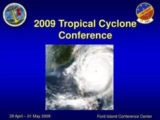
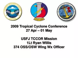
2009 Tropical Cyclone Conference 27 Apr – 01 May USFJ TCCOR Mission 1Lt Ryan Willis 374 OSS/OSW Wing Wx Officer. Agenda. US Forces Japan (USFJ) Tropical Cyclone Support Roles/Responsibilities Tropical Cyclone Condition of Readiness (TCCOR) Defined Procedures on a “Typical Day”

E N D
2009 Tropical Cyclone Conference 27 Apr – 01 May USFJ TCCOR Mission 1Lt Ryan Willis 374 OSS/OSW Wing Wx Officer
Agenda • US Forces Japan (USFJ) Tropical Cyclone Support • Roles/Responsibilities • Tropical Cyclone Condition of Readiness (TCCOR) Defined • Procedures on a “Typical Day” • Lessons Learned • Important Notes • Questions
USFJ TC Support • Roles/Responsibilities • Per USFJ Instruction 15-4001, USFJ/CC has delegated TCCOR to USFJ/J3 (Operations). • J3 is the TCCOR Declaration Authority • 5 AF Staff Weather Officer (also 374 OSS/OSW Flight Commander) is the TCCOR Recommending Authority • J3 declares TCCORs 4-1, Storm Watch, and All Clear for Kanto Plain (Yokota, Atsugi, Camp Zama, Camp Fuji) • Installation Commander (example: 374 AW/CC) declares TCCORs 1C, 1E, 1R
USFJ TC Support • TCCOR is defined by timing of destructive winds (> 50 kts sustained) • TCCOR 4: Destructive winds possible within 72 hours • TCCOR 3: Destructive winds possible within 48 hours • TCCOR 2: Destructive winds anticipated within 24 hours • TCCOR 1: Destructive winds anticipated within 12 hours • TCCOR 1 Caution: Observed winds 35-49 knots are occurring • TCCOR 1 Emergency: Destructive winds are occurring • TCCOR 1 Recovery: Period of time to survey damage/create safety • TCCOR Storm Watch: Close proximity & erratic movement • TCCOR All Clear: Storm is over and not forecast to return • Kanto Plain Declaration Authority • USFJ/J3 TCCOR 4, 3, 2, 1, All Clear, Storm Watch • 374 AW/CCTCCOR 1C, 1E, 1R
USFJ TC Support • Procedures on a “Typical Day” • 0600L 18z Warning Graphic Available • 0630L JTWC Conference Call • 0700L TC Update Email to Wing Leadership • 0730L Kanto Plain Conference Call/Slides Due to Wing • 0800L Draft TCCOR Declaration Message/Daily Wing Briefing • 0830L Discuss TCCOR Declaration Message (J3) • 0900L Distribute TCCOR Declaration Message/Notifications • 0930L Wing Briefings (if required)/Phone Calls • 1200L 00z Warning Graphic Available • 1300L TC Update Email to Wing Leadership/Briefs/Phone Calls • Entire work day is absorbed by 1 storm impacting Kanto Plain!
Lessons Learned • Communication is key! • USFJ/J3 drives almost all TCCOR changes, but 374 AW/CC needs visibility as soon as possible (“who to brief first”) • Conference call with JTWC sets baseline/forecast reasoning • Conference call with Yokosuka imperative (CNFJ vs USFJ missions) • Maintain single forecast once established (minimize misinformation) • Storms ALMOST never go as forecast (TY 15W had 47 warnings!) • Wind effects between Yokosuka and Kanto Plain bases • Yokosuka exposed/vulnerable to ocean • Atsugi usually sees drop off on winds from Yokosuka • Yokota “rarely” gets strong winds (terrain influence) • Sea of Japan tracks tend to deliver better winds at Yokota
Important Notes • Products have HIGH visibility! • JTWC and 17 OWS products are seen by high ranking officials • USFJ/J3 reports directly to 5AF/CC (3 star general) • Tropical products and forecasted tracks need to be fairly consistent with each new update
Questions? MODIS visible image of Typhoon Man-Yi (04W) as it passed northeast of Iwo To on 6 Aug 2007. Image courtesy of NASA Earth Observatory