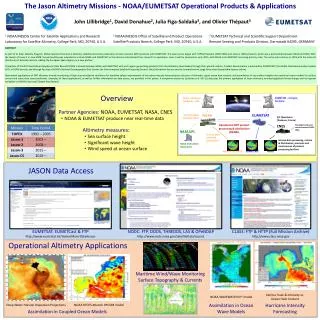
Download
1 / 11
110 likes | 222 Vues
Air Quality Products from NOAA Operational Satellites. Presented by Shobha Kondragunta. Requirement, Science, and Benefit. Requirement/Objective Weather & Water: Provide information to air quality decision makers and improve NOAA’s national air quality forecast capability

E N D
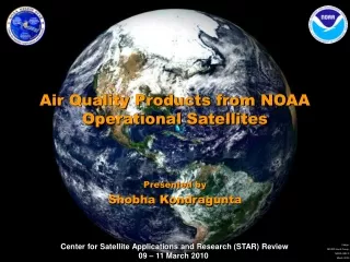
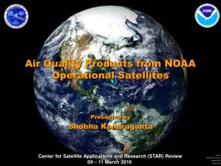
Air Quality Products from NOAA Operational Satellites Presented by Shobha Kondragunta
Requirement, Science, and Benefit Requirement/Objective • Weather & Water: • Provide information to air quality decision makers and improve NOAA’s national air quality forecast capability • Improve understanding of the connection between climate and shorter-term high impact air quality events to inform decision-makers. • Climate Variability • Enhance NOAA’s operational decision support tools to provide climate services for national socio-economic benefits Science • What are the optimal approaches by which satellite remote sensing, in situ observations, and models can be integrated to provide accurate and useful decision support for air quality assessments and predictions? • How can we best exploit satellite observations to monitor, track, and differentiate between various natural and anthropogenic emissionsof gases and aerosols important to public health? Benefit • Understand the effect of environmental factors on human health and well being • General public (recipients of air quality warnings) • Clean Air Interstate Rule, Clean Air Act, regional haze rule, exceptional events monitoring, etc. • Development of short-term and long-term pollution mitigation strategies by state and local environmental agencies • International users • Algorithm/product development
Challenges and Path Forward • Science challenges • Retrieving vertical profiles of trace gases and aerosols • Lack of in situ data to validate GOME-2 NO2 product • Lack of in situ data to validate biomass burning emissions product • Next steps • Continue algorithm enhancement work for current operational products • Prepare for next generation satellite sensors (GOES-R, NPP/NPOESS) • Improve coordination with users to enhance data use and develop new applications • GOES-R air quality proving ground launched in 2009 • Develop validation campaigns • Transition Path • Research to Operations • GEO-CAPE transition team • Collaboration with NASA and EUMETSAT in areas of algorithm development • Participation in CEOS and GEOSS • Atmospheric composition constellation • Air quality community of practice • Assimilation and/or model improvements based on satellite data • JCSDA air quality working group • EPA AIRNow, Remote Sensing Information Gateway (RSIG) • Operational dissemination of air quality information which includes NOAA satellite data
NOAA Operational Air Quality Products(SPSRB Approved) • Aerosol Optical Depth: quantitative measure of atmospheric aerosol loading that has been shown to be a proxy for surface particulate matter pollution, PM2.5 (aerosol mass in µg/m3). • Single channel retrieval using measured visible channel reflectances from GOES Imager. • IR channels used in identifying clouds. • Physical retrieval that separates contribution of surface from aerosols. • Automated Smoke Detection and tracking Algorithm (ASDA): semi-quantitative retrieval of column average smoke concentration (µg/m3) using AOD and fire hot spots from GOES. • Uses source apportionment and pattern recognition techniques to isolate smoke aerosols from other type of aerosols.
NOAA Operational Air Quality Products (SPSRB Approved) • Tropospheric Nitrogen Dioxide: quantitative retrieval of tropospheric nitrogen dioxide (NO2) that is a precursor to photochemical smog formation. • Differential Optical Absorption Spectroscopy (DOAS) technique takes advantage of fine absorption features of NO2 in the UV-VIS. • Slant columns are converted to vertical column densities using air mass factors and stratospheric component is removed from the total column to obtain tropospheric NO2 amounts.
NOAA Operational Air Quality Products(SPSRB Approved) Seasonal Burned Area over Alaska from GOES-11 in 2009 Emissions (g) = Burned area (ha)*fuel load (kgC/ha)*emissions factors (g/kgC)* fuel consumed (%) Global Geostationary Based Biomass Burning Emissions of PM2.5 Fuel Load (kgC/ha) • Biomass Burning Emissions Product: • Conventional approach uses fuel load, burned area, fraction of fuel consumed, and emissions factors to determine emissions. STAR developed a new fuel load dataset using MODISland products. • Alternate algorithm based on fire radiative power to calculate emissions is currently being tested.
Air Quality Applications of NOAA Operational Satellite Data Weekday Weekend Tracking NOx Emissions using GOME-2 NO2 Data Weekday/weekend differences in NOx emissions as observed by GOME-2 are expected to help evaluate and update emissions in air quality forecast models
Air Quality Applications of NOAA Operational Satellite Data Modeling and Assimilation • Assimilation of GOES Aerosol Optical Depth (AOD) in a NOAA-EPA Weather and Research (WRF)/Community Multiscale Air Quality (CMAQ) model shows improved aerosol predictions for an eastcoast pollution episode Assimilation Assimilation No Assimilation Significance: Accounting for missing sources and sinks in the model via aerosol data assimilation helps improve particulate pollution predictions. NWS is mandated to deploy nationwide PM2.5 forecasts early next decade. This research will help NWS meet its mandate.
Air Quality Applications of NOAA Operational Satellite Data Integrated observations, products and synthesis to support air quality forecasters
Air Quality Applications of NOAA Operational Satellite Data 7/13/09, 17-18Z, Observation: GOES smoke product: Confirms areal extent of peak concentrations Threat Score = 30%, for column-averaged smoke > 1 ug/m3 Sample NWS Smoke Forecast Verification, 13 July 2009 17Z – 18Z Prediction
Challenges and Path Forward • Science challenges • Retrieving vertical profiles of trace gases and aerosols • Lack of in situ data to validate GOME-2 NO2 product • Lack of in situ data to validate biomass burning emissions product • Next steps • Continue algorithm enhancement work for current operational products • Prepare for next generation satellite sensors (GOES-R, NPP/NPOESS) • Improve coordination with users to enhance data use and develop new applications • GOES-R air quality proving ground launched in 2009 • Develop validation campaigns • Transition Path • Research to Operations • GEO-CAPE transition team • Collaboration with NASA and EUMETSAT in areas of algorithm development • Participation in CEOS and GEOSS • Atmospheric composition constellation • Air quality community of practice • Assimilation and/or model improvements based on satellite data • JCSDA air quality working group • EPA AIRNow, Remote Sensing Information Gateway (RSIG) • Operational dissemination of air quality information which includes NOAA satellite data