Download

1 / 11
110 likes | 444 Vues
Caribbean Volcanic Arc- Pico Duarte. By: Nicki Schuchter. Pico Duarte. Google Satellite image of Pico Duarte, Dominican Republic. Pico Duarte. This is an actual picture of Pico Duarte. Pico Duarte Topographic Map. http ://www.peakbagger.com/peak.aspx?pid=8224. Features- Haiti.

E N D
Caribbean Volcanic Arc- Pico Duarte By: Nicki Schuchter
PicoDuarte Google Satellite image of Pico Duarte, Dominican Republic
Pico Duarte This is an actual picture of Pico Duarte.
Pico Duarte Topographic Map http://www.peakbagger.com/peak.aspx?pid=8224
Features-Haiti Pico Duarte is in the nation of Dominican Republic, which is on the Island of Hispaniola. Dominican Republic shares this island with Haiti.Haiti is to the west of Dominican Republic.
Features- Caribbean Sea The Caribbean Sea is a sea in the Atlantic Ocean. It is bound to Mexico, Central America, and the all the islands in the Caribbean volcanic arc.
Puerto Rico Puerto Rico is another island that is apart of the Greater Antilles (Cuba, Jamaica, Hispaniola). It is the closest island to the east of Pico Duarte (Dominican Republic, Hispaniola)
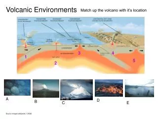
Boundary, Fault, Stress? Type of plate boundary: Convergent Type of fault: Reverse Type of stress: Compression
Pico Duarte is located on Dominican Republic is the Caribbean islands- 19°N 70°W • -It was formed in the mid 1900s from the collision of the Caribbean Plate and Cocos Plate. Location
Elevation and Slope • Pico Duarte’s lowest elevation is 1,900 m • Pico Duarte’s highest elevation is 3,098 m (10,164 ft) • Pico Duarte’s slopes are the steepest between 2,700 m and 2,800 m
!Extras! Pico Duarte was named in honor of Juan Pablo Duarte, one of the Dominican Republic's founding fathers.