
Uploaded by
vito
2 SLIDES
132 VUES
20LIKES
Multi-Point ZVI Analysis Using Digital Height Data and Contour Ground Model
DESCRIPTION
This document outlines the methodology for conducting a multi-point Zero Visual Impact (ZVI) analysis using digital height data and contour ground models. It includes steps for specifying analysis points, running the analysis, and generating a visibility model file, along with an elevation analysis visibility map. The process aims to assess landscape visual impacts effectively and provides a framework for environmental assessments in various projects.
Download
1 / 2
Download Presentation

Télécharger la présentation
Multi-Point ZVI Analysis Using Digital Height Data and Contour Ground Model
An Image/Link below is provided (as is) to download presentation
Download Policy: Content on the Website is provided to you AS IS for your information and personal use and may not be sold / licensed / shared on other websites without getting consent from its author.
Content is provided to you AS IS for your information and personal use only.
Download presentation by click this link.
While downloading, if for some reason you are not able to download a presentation, the publisher may have deleted the file from their server.
During download, if you can't get a presentation, the file might be deleted by the publisher.
E N D
Presentation Transcript
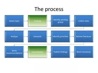
The ZVI Process Key TERRA-FIRMA
Multi-Point ZVI Analysis Digital height data – Contours Ground Model File - .KGM Specify analysis points Run analysis Visibility Model File - .KGM Elevation Analysis Visibility Map


More Related
Audio
Live Player