Download
1 / 62
620 likes | 902 Vues
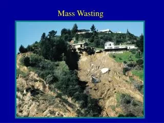
Ch. 15 Mass Wasting. “stuff rolls downhill”. Mass Wasting. The downslope movement of rock, regolith, and soil under the direct influence of gravity. Does not require a transporting medium. It is the process that takes place between weathering and erosion.

E N D
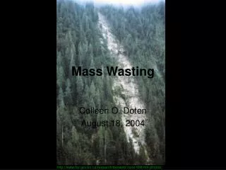
Ch. 15 Mass Wasting “stuff rolls downhill”
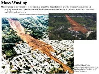
Mass Wasting • The downslope movement of rock, regolith, and soil under the direct influence of gravity. • Does not require a transporting medium. • It is the process that takes place between weathering and erosion. • Combined effects of mass wasting and running water produce stream valleys • From slow imperceptible creep to fast moving avalanches.
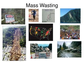
Why is mass wasting important? • MW processes represent a significant hazard to people and property • Need to identify where and under what conditions these occur • Avoid construction in areas prone to mass wasting • Attempt to prevent mass wasting
Mass Wasting and landform development • For mass wasting to occur, there must be a slope angle • Most rapid events occur in areas of rugged, geologically young mountains • As a landscape ages, less dramatic downslope movements occur
Controls on Mass Wasting • Gravity is the controlling force. • Water is a factor. • Destroys cohesion or internal resistance between particles. • Creates buoyancy for masses of regolith and soil, thereby reducing the frictional coupling with the underlying substrate. • Adds considerable weight to the mass of material. • Changes the properties of clay; clay becomes "slick" when wetted.
Controls on Mass Wasting • Adding material to the top of the slope or undercutting the slope at its base can increase the angle of repose. • Oversteepening of slopes is a factor. • Rock debris is stable at slope angles less than the angle of repose. • Angles of repose vary between 25 and 40 degrees depending on the materials.
Classification is based on: • Type of material • Unconsolidated vs. consolidated (e.g., bedrock) • Dry vs. water saturated • Type of motion • Fall: Free-fall on steep slopes. Forms talus slopes • Slide: Movement along well-defined surface; material remains fairly coherent. • Flow: Material moves as a viscous fluid, usually when saturated with water. • Rate of movement
Slump • Downward sliding of a mass of rock or unconsolidated material moving as a unit along a curved surface. • Slumped material does not travel very fast or very far. • Crescent-shaped scarps are formed. • Water percolating downward and along the curved surface may promote further instability through lubrication and buoyancy. • Commonly occurs on slopes that have been oversteepened.
Rockslide or debris slide • Downward sliding of blocks of bedrock that have broken loose. • Among the fastest and potentially most destructive of the mass wasting processes. • Often occurs in areas where the rocks are highly fractured, particularly if the fracture surfaces or bedding planes dip downslope. • Often triggered by an earthquake. • Examples - Madison River and Gros Ventre rockslides
Mudflow • Rapid type of mass wasting that involves a flowage of debris containing a large amount of water. • Most characteristic of semiarid mountainous regions. • Tend to follow canyons and gullies. • Lahars are mudflows on the slopes of volcanoes, often accompanying eruptions. E.g., Mount St. Helens.
Earth flow • Downslope movement of water-saturated soil on hillsides in areas of deep weathering. • Form tongue-shaped masses with well-defined head scarps. • Moves relatively slowly and may be active for periods ranging from days to years.
Creep • Imperceptibly slow downslope movement of soil and regolith. • Can take place on even gentle slopes and is extremely widespread. • A primary cause is the alternate expansion and contraction of surface materials caused by freezing and thawing or wetting and drying.
Los Angeles Against the Mountains Debris Flows in Southern California
What causes debris flows in LA? • San Gabriel Mtns • deeply fractured due to stresses on the rocks caused by faults • rapidly uplifting and weathering • Very steep slopes • Fires • Strip vegetation from the slopes • Combustion of chaparral plants leaves wax-like substance about 1 cm below soil surface. This prevents infiltration of rain and increases runoff • Rain • LA averages ~ 15 in/yr. • San Gabriels can get extreme rainfall events • Jan. 1969 - >44 ins. in 9 days • Feb. 1978 – 1.5 ins. In 25 minutes • April 5, 1926 – 1 in. in 1 minute
San Gabriel Fault San Gabriel Mountains
Home destroyed by a small debris flow during the winter of 1980
What can be done? Deflector wall
Can it happen here? What do you think?