Download
1 / 61
770 likes | 1.4k Vues
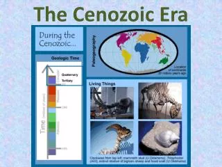
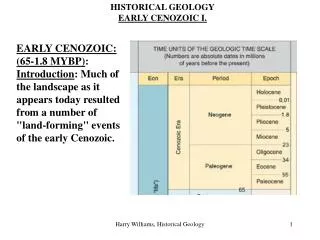
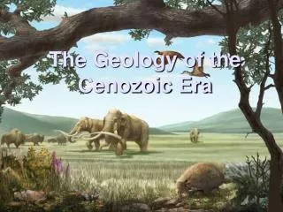
The Geology of the Cenozoic Era. Introduction. The Cenozoic began ~65 mya and continues until the present Cenozoic rocks are more easily accessible and less deformed than older rocks divided into the Tertiary and Quaternary. Early Work on the Cenozoic.

E N D
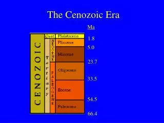
Introduction • The Cenozoic began ~65 mya and continues until the present • Cenozoic rocks are more easily accessible and less deformed than older rocks • divided into the Tertiary and Quaternary
Early Work on the Cenozoic • Charles Lyell England’s foremost geologist of his day. • Author of Principles of Geology (1830) • Supported James Hutton's concepts of Uniformitarianism • Teacher of Charles Darwin Charles Lyell studied the TertiaryandQuaternary fossils of France Defined the Eocene, Miocene, Pliocene, Pleistocene, and Holocene Paleocene and Oligocene were added later
Geologic Events Cenozoic Mantle upwelling Colorado Plateau Washington Laramide uplifts eroded away (Longest Tertiary Epoch) Rockies
Cenozoic Tectonic activity concentrated in two areas • Alpine-Himalayan belt deformation began in the Mesozoic and remains geologically active. Isolation of Tethys to form the modern Mediterranean Sea • circum-Pacific belt deformation occurred throughout the Cenozoic
Cenozoic Pacific realm • Subduction of the Farallon Plate and its Mid Ocean Ridge • 2. Formation of Andean Cordillera San Andreas forms
Geologic Events Cenozoic Mantle upwelling Colorado Plateau Washington , Basin & Range San Andreas Fault (Longest Tertiary Epoch) Rockies
Cordillera • Circum-Pacific Orogenic belt • Laramide Lt. Jur - E Tertiary • further inland than most - CLUE • deformation was vertical uplift, with little volcanism • shallow subduction angle • “buoyant subduction”
Laramide Orogeny K to TBuoyant Subduction • One possible result of shallow angle of subduction and the drag that it causes with overlying lithosphere is uplift - Rocky Mountain formation. • Renewed normal subduction would restore normal volcanism within the western part of the mountains – Basin and Range
Upliftof the Rocky Mountains Rockies shear stress Basin and Range
Teton Range Laramide uplifts eroded away in Oligocene, renewed uplifts Late Mio – Pleist.
Basin and Range of Cordillera Columbia River Basalts Basin and Range • Beginning in the Miocene, 2 mechanisms • lessening of the subduction angle allows dewatering volcanism further west. • Farallon pieces under the lithosphere cause uplift, lithosphere cracking and buoyant decompression magmas.
Basin and Range terminology DISCUSSION, SHIP HULLS Extensional Feature w/ Normal Faults
Geologic Events Cenozoic Mantle upwelling Colorado Plateau Washington San Andreas Fault, Basin & Range (Longest Tertiary Epoch) Rockies
San Andreas transform Ridges Change Orientation 15 mya SAF forms
The Interior Lowlands • Sediments eroded from the Laramide highlands were deposited in the Cannonball Sea Early Paleocene south to North Dakota. • Terrestrial deposits are also found, but much of this area was experiencing erosion • Igneous activity was significant in some areas - New Mexico, Colorado, Wyoming, and others • East of the Great Plains, deposits other than glacial are rare until the eastern coastal plain.
The Gulf Coastal Plain • The Tejas epeiric sea transgressed briefly over the southeastern coastal plains E. Tertiary • eight minor transgressive-regressive sequences are recognized as sea level fell in general – reduced rifting
East Coast • Passive margin sedimentation dominates • rocks form a seaward thickening wedge that dips gently seaward • Cenozoic uplift and erosion produced the present topography of the Appalachians • Coastal Plain a thick clastic wedge • Florida Carbonates Pliocene - Recent
Eastern North America Allegheny Orogeny still high Erosion due Transgression Coastal Plain streams and marshes Appalachians rejuvenated recently, probably glacial rebound
2. Eocene to Miocene 1.Alpine Orogen Apennine Balkan Carpathian Caucasus Pyrenees Atlas 4.Closing of the Tethys Sea 3. Vocabulary: Nappe Large recumbent folds in thrust-fault zones where orogenic belts impinge craton margins Flysch alternating thin shales and sandstones. Sandstones turbidites prior orogenic collision. Molasse non-marine deposits accompanying the uplift of a mountain belt. Isolation of the Mediterranean Basin: Evaporites
New Orogen, Nappes still visible http://www.geol-alp.com/chartreuse/3_tecto_chartreuse/1_ch_occ.html
1. The underside of Europe collided with numerous microplates rifted from Africa Closing of the Tethys Sea between late Mesozoic and early Cenozoic time 4. Thrusts not Subduction Arabian-African Rift 3. Messinian Salinity Crisis ~ 5.5 mya 2. Pliocene three way rift. 3. Arabia Microcontinent collision -> Zagros Mts
Himalayan Orogeny Thin-skinned tectonics Subduction Partly subducted so under AW
Himalayan Orogeny Zoomed-in Views AW FAB
Generalized Cross-Section North South
Décollement • Décollement (from the French 'to detach from') is a gliding plane between two rock masses, also known as a basal detachment fault. • Décollements result in independent styles of deformation in the rocks above and below the fault. • Both compressional settings (involving folding and overthrusting) and extensional settings.
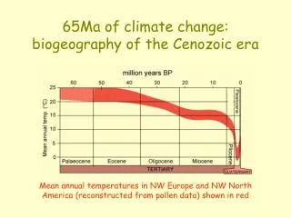
Cenozoic Climates, Currents, and Volcanism • Ocean current flow changes due to tectonics in Antarctic-Australian and Central American regions • Dramatic changes in climate • Major plume under North America • Continuous cooling, culminating in on-going Ice Age
Cenozoic Cooling Central America construction Starts see Monterey Fm. Australia separates (Northern Hemisphere)
Geologic Events Cenozoic Panama Closes Mediterranean Dries Out Circumpolar Current Antarctica (Longest Tertiary Epoch) High CO2 Rockies
Antarctic Circumpolar Current Paleocene to Mid-Eocene WARM Currents from Tropics
Early Eocene Warm Green River Formation Oil Shales
Green River Formation Lake (lacustrine) silts Organic-rich (oil) shales w/ fossils
Green River Formation Tropical Plants to High Latitudes
Antarctic Circumpolar Current 2. Late Eocene Sudden Antarctic cooling as warm currents barred 3. 5. Longest continuous Ice Sheets 4. Fauna changes. Example: Penguin relationships from S. American bird following current rich in fish. 1. Australia pulls away
Fossils in volcanic tuff deposit Cooler Tree stumps, insects in Oligocene Ash, Florissant, Colorado Extensive Volcanism Late Eocene to Oligocene
Pre Gulf Stream Current Isthmus of Panama open, same salinity Atlantic and Pacific Early Pliocene
Modern Gulf Stream Current 1. Terranes, Subduction, Volcanic Arc, Isthmus of Panama closed, North Atlantic isol., higher salinity, dense cool water sinks before it reaches Arctic, polar sea freezes Late Pliocene Mediterranean Dried Out 2. Caused Formation of the present Gulf Stream Current in the Atlantic 3. Dramatic Cooling
Late Pliocene 5.96 to 5.33 mya Messinian Salinity Crisis – recall salt buoyancy, low competence Evaporites, Gorges, Faunal Exchanges
The Great Exchange • Bears • Camels • Cats • Dogs • Elephants • Horses • Peccaries • Rabbits • Raccoons • Skunks • Tapirs • Weasels North America Anteaters Armadillos Capybaras Glyptodonts Monkeys Opossums Porcupines Sloths Toxodonts South America Late Pliocene, Isthmus of Panama closed, migrations North and South
With cooling comes drought. Grasses replaced forests, mammals adapted for a diet of grass, grew larger, faster as predators pursued.
Geologic Events Cenozoic Mantle upwelling Colorado Plateau Washington Laramide uplifts eroded away (Longest Tertiary Epoch) Rockies
Pliocene 2000 m uplift of Colorado Plateau (Grand Canyon - Colorado River incised ) Evidence, Incised meanders
The Yellowstone Plume • Miocene to Recent • Starts with flood basalts in Columbia Plateau Washington and Oregon 15 mya • Continues into Snake River Basin • Then to Yellowstone in Holocene
Basalt flows - Columbia Plateau Miocene 15 – 12 mya Start of Plume forming Snake River Plateau and recently Yellowstone Just like the Watchungs
Craters of the Moon Monument Migration of Snake River Basin over the plume 10 mya Migration of Yellowstone Park over the plume 2 mya to recent
Geologic Events Cenozoic (Longest Tertiary Epoch) Rockies
Pleistocene Glaciation • The Pleistocene began about 1.8 – 1.6 mya and ended about 10,000 years ago • several intervals of widespread glaciation took place, separated by warmer intervals