Download
1 / 17
200 likes | 395 Vues
Discover the majesty of the Congo River, its wildlife, tributaries, dams, and unique features. Learn about its impact on transportation, ecology, and challenges with pollution in the Democratic Republic of Congo.

E N D
Congo River (Zaire River) By: Dongin Oh
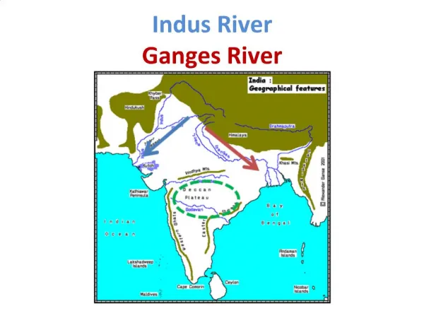
Location • It is located in Democratic Republic of Congo. It flows through following countries, they are: Zaire, Angola, Zambia, Cameroon and Tanzania. Congo river flows through these major cities they are Novobirsk, Barnaul, Mogochin and Akademgordok
Estuary • Estuary of Congo is located in Matadi which is in Democratic Republic of Congo. There are mangrove forests abut the outer estuary. The shallow inner estuarine region is dissected into channels with associated islands and swamps. Congo river flows to Atlantic to Atlantic ocean
Facts • Congo river is 2920 miles long, it is tenth longest river in the world. It is also deepest river in the world. Length affects to transportation because it is long river. People transportation for both good and humans.
Key Features • River flows for the most part of equator, the area around is vey hot. Much of land surrounding the river is rainforest. In addition, insects such as mosquitoes and gnats are prevalent in hot, humid condition.
Animals • Congo river is home to hundreds of animals including hippos, manatees, water snakes, crocodiles, tortoises, pigs, elephants and over 200 kinds of fish. Some parts of the surrounding land are full of long grass called "barnyard grass." Many animals graze in this tall grass, including buffalo, antelopes, zebras, gazelles, and giraffes.
Tributaries • Aruwimi river, Kasai river, Lomami river, Lualaba river and Ubangi are tributaries of Congo river.Aruwimi river is located in Central Africa, Lomami river is located in Democratic Republic of Congo, Lualaba river is located in Democratic Republic of Congo and Ubangi river is located in Central Africa. Shape of tributaries is interesting because Congo looks like trunk of the tree and tributaries look like branches. Tributaries provide the Congo basin with an overall stability against variations in rainfall.
Dams, meanders, bridges and waterfalls • In Congo river there are four following dams they are: Inga 1, Inga 2, Inga 3 and Grand Inga. Meanders flows through Central Africa and slides down again. There is one famous bridge is called Matadi bridge. There are 30 waterfalls, one of famous waterfall is called Inga falls. Grand Inga and Matadi bridge is important. Grand Inga is important because it is most powerful power generating dam ever. It generates nearly twice as more than Three Gorges Dam. Matadi is a suspension bridge in part of Matadi, Democratic Republic of Congo. It has a main span of 520m, crossing the Congo river. It links the parts of Boma and Banana.
How river is used • River is used for transportation, tourist attraction, watering plants and fishing. It affects people’s daily lives by watering plants everyday, raising money from attracting tourists.
Health of the river • Source of the river is polluted and main river is polluted. Source pollution is derived from soil erosion and municipal wastes. Main river is polluted because of transportation. Fishes in the river are affected because in the river there are some oil inside which is by the boats. People are affected by polluted air and dirty water. Pollution is caused by boats for transportation, but they need to transport because there aren’t many roads in Zaire so most of travelling is done on Congo river. Actually Congo river is Africa’s main navigational system.
Special facts • Congo river is unique because shape of the river looks like a “n”. It is different from other rivers in the word because river forms most of the border between Zaire and Democratic Republic of Congo. River drains more than 1,600,000 square miles of the land. The river has a width in a range of 0.5 to 10 miles.It is also the deepest river in the world, with measured depths in excess of 230 m (750 ft).
Quiz • Q1: How does shape of cong river looks like? • Answer: It looks like a “n” • Q2: How wide is Congo river? • Answer: It is width in a range of 0.5 to 10 miles • Q3: What is other name for Congo river • Answer: Zaire river • Q4: Where is mouth of Congo river is located? • Answer: Matadi • Q5: Into what ocean it flows to? • Answer: Atlantic Ocean • Q6(extension): How long is Congo river in km?(one mile is about 1.6km and Congo river is 2920 miles long) • Answer: 4672km
Websites • http://www.socialstudiesforkids.com/articles/geography/congoriver.htm • http://en.wikipedia.org/wiki/Congo_River • http://webbryant.edu/~langbis/ecology/pollution.htm • http://en.wikipedia.org/wiki/Kasai_River • http://en.wikipedia.org/wiki/Lomami_River • http://en.wikipedia.org/wiki/Lulaba • http://en.wikipedia.org/wiki/Aruwimi_River • http://en.wikipedia.org/wiki/Ubangi_River • http://earthobservatory.nasa.gov/Newsroom/view.php?id+22131 • http://nest.su.se/mnode/Africa/congobud.htm
The end • Thank you for listening my presentation and I hope you learn lots of facts about Congo river!