Download
1 / 13
140 likes | 315 Vues
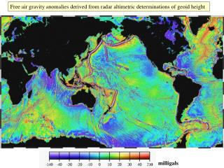
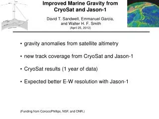
Improved Marine Gravity from CryoSat and Jason-1 David T. Sandwell, Emmanuel Garcia, and Walter H. F. Smith (April 25, 2012). gravity anomalies from satellite altimetry new track coverage from CryoSat and Jason-1 CryoSat results (1 year of data) Expected better E-W resolution with Jason-1

E N D
Improved Marine Gravity fromCryoSat and Jason-1David T. Sandwell, Emmanuel Garcia, and Walter H. F. Smith(April 25, 2012) • gravity anomalies from satellite altimetry • new track coverage from CryoSat and Jason-1 • CryoSat results (1 year of data) • Expected better E-W resolution with Jason-1 • (Funding from ConocoPhillips, NSF, and ONR.)
radar altimetry Our objective of 1 microradian slope accuracy requires 1 cm range precision over 10 km distance. Ocean surface waves are the main limiting factor on range precision.
available altimeter data before CryoSat 1985 1995 Note - The Topex track spacing is > 200 km so it provides little new information. GRACE and GOCE cannot resolve features smaller than 200 km.
Achieving 1 mGal Gravity Accuracy • Improved range precision-- A factor of 2 or more improvement in altimeter range precision, with respect to Geosat and ERS-1, is needed to reduce the noise due to ocean waves. • Fine cross-track spacing and long mission duration -- A ground track spacing of 6 km or less is required. • Moderate inclination -- Current non-repeat-orbit altimeter data have high inclination and thus poor accuracy of the E-W slope at the equator. • Near-shore tracking -- For applications near coastlines, the ability to track the ocean surface close to shore is desirable.
CryoSat source: ESA • Launched by ESA in February, 2010. • Primary mission to measure sea ice thickness and ice cap volume. Also operates over all ocean areas to 88˚ latitude. • First new altimeter mission with long repeat cycle (369 days) since ERS-1 in 1995. • Operates in 3 modes: • LRM –- conventional mode used by all previous altimeters. (excellent data quality) • SAR –- synthetic aperture radar mode may provide 2-4 times better range precision. • SARIN -– uses two receiving antennas to also measure cross-track slope.(poor data quality)
Jason-1 • Launched by NASA and CNES in 2001. • Primary mission to monitor global ocean circulation in 10-day repeat cycle at 66˚ inclination to continue the Topex time series. 300 km track spacing not useful for marine gravity recovery. • Replaced by Jason-2 in June 2008. Engineers concerned that when Jason-1 dies, it will collide with Jason-2 and they recommend moving the satellite to a different orbit. “End of life” committee suggest a 419-day geodetic orbit. • Jason-1 goes into safe hold in March 3, 2012. Maneuvers to new orbit began April 24, 2012. New operations begin May 4, 2012.
Caspian Sea altimeter tracks 419-day coverage begins May 4, 2012 old tracks new tracks planned tracks
predicted gravity improvement 3 years of CryoSat and 419 days of Jason Error in north and east components was averaged.
CryoSat Data Acquisition over 13 Months LRM SAR SARIN [CryoSat L1b data provided by ESA ESRIN]
Comparisons in the Gulf of Mexico satellite gravity with CryoSat LRM ship gravity source: EDCON 5 mGal contour interval
Comparisons in the Gulf of Mexico satellite gravity with CryoSat LRM vs. ship gravity rms = 1.86 rms < 2 mGal
north slope q east slope orbit inclination controls error anisotropy • Error propagation q - local inclination of track s - error in along-track slope sx - error in east slope sy - error in north slope • Orthogonal tracks are optimal
contributions from Jason-1 Without Jason, the error in the east slope component is large so N-S features such as the East Pacific Rise will be poorly resolved. One 419-day cycle provides about 25% improvement in east slope and two cycles provides about a 33% improvement. Most of the area of the earth is at latitude less than 60 degrees where Jason will make the largest improvement.