USDA Geospatial Data Warehouse
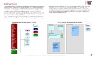
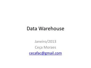
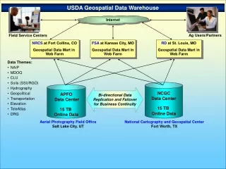
USDA Geospatial Data Warehouse. Internet. Ag Users/Partners. Field Service Centers. NRCS at Fort Collins, CO Geospatial Data Mart in Web Farm. FSA at Kansas City, MO Geospatial Data Mart in Web Farm. RD at St. Louis, MO Geospatial Data Mart in Web Farm. Data Themes: NAIP MDOQ


USDA Geospatial Data Warehouse
E N D
Presentation Transcript
USDA Geospatial Data Warehouse Internet Ag Users/Partners Field Service Centers NRCS at Fort Collins, CO Geospatial Data Mart in Web Farm FSAat Kansas City, MO Geospatial Data Mart in Web Farm RD atSt. Louis, MO Geospatial Data Mart in Web Farm • Data Themes: • NAIP • MDOQ • CLU • Soils (SSURGO) • Hydrography • Geopolitical • Transportation • Elevation • TeleAtlas • DRG NCGC Data Center 15 TB Online Data APFO Data Center 15 TB Online Data Bi-directional Data Replication and Failover for Business Continuity Aerial Photography Field Office Salt Lake City, UT National Cartography and Geospatial Center Fort Worth, TX
Disk Array Disk Array Tape Library Tape Library Field Service Center GISGDW Architecture Internet Web Farms St Louis Ft Collins Kansas City Replication Data Centers Salt Lake City/APFO Ft Worth/NCGC
GDW and NAIP Delivery Near Line Component Tape silo Archive On-line Component Arc SDE Database Supports web service 3. Delivery Component APFOBD Geospatial Data Gateway Data Provisioning System WMS image streaming
NAIP Delivery Two Products • Compressed County Mosaics • Full Resolution Quarter Quads
NAIP Delivery Compressed County Mosaics • Optimized for local use • -MrSID MG3 format • -compressed • -performs well • image pyramid • “Interim Release” • Before QA • 30 days after acquisition • “Final Release” • -Can contain/represent rework
NAIP Delivery Quarter Quadrangles • “Raw Data”, “Basic Building Blocks” • -non-proprietary format (GeoTIFF) • -quarter quad unit corresponds • -single acquisition date • -metadata reference
Annual NAIP Timeline (2004) May June July Aug Sept Oct Nov Dec Jan Feb Mar April May Image Acquisition Full Resolution Quarter quads QA “Interim” Compressed County Mosaic Project Close out Cost Share Partners Cost Share Partners
Annual NAIP Timeline (2005-06) May June July Aug Sept Oct Nov Dec Jan Feb Mar April May Image Acquisition Full Resolution Quarter quads QA “Interim” Compressed County Mosaic Project Close Out Cost Share Partners Cost Share Partners
NAIPProduction Process Acquisition
NAIPProduction Process Aero Triangulation Acquisition
NAIPProduction Process Aero Triangulation Ortho Production Acquisition
NAIPProduction Process Compressed County Mosaics Aero Triangulation Ortho Production Acquisition
Annual NAIP Timeline (2005-06) May June July Aug Sept Oct Nov Dec Jan Feb Mar April May Image Acquisition Full Resolution Quarter quads QA “Interim” Compressed County Mosaic Project Close Out Cost Share Partners Cost Share Partners