API
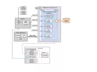
Security. TX. API. Command API. Other APIs. Services. Spatial. Non-spatial. Domain. POJO. Persistence. Hibernate. Spatial database. Dojo Face. GWT Face. ???. Rendered Feature. Raster Image. ???. Server API. Feature command. Raster Command. Geoprocessing Command. ???.


API
E N D
Presentation Transcript
Security TX API Command API Other APIs Services Spatial Non-spatial Domain POJO Persistence Hibernate Spatial database
DojoFace GWTFace ??? RenderedFeature RasterImage ??? Server API Featurecommand RasterCommand GeoprocessingCommand ??? Application Map VectorLayer RasterLayer WMSLayer ??? GoogleLayer Geotools LayerModel Hibernate LayerModel Custom LayerModel Feature POJO ??? OGC/otherServices Spatial DB
Geomajas Customextension backendapi backend backendapi Customlayer model backendapi backendapi backendapi Custom face dojo face server GWT face server face internal face internal server client dojo face client GWT face client dojo faceapi GWT faceapi dojoapp GWT app
backend ApplicationCommand Including parameters, ApplicationResult Includes return values For display, these are typically RenderedTile instances Face server serialized ApplicationCommand face client serialized applicationResult
layermodel hibernate layermodel geotools Geomajas-api Geomajas-impl layermodel google layermodel wms Extension printing Extension editing layermodel openstreetmaps Geomajas backend