Download
1 / 21
220 likes | 406 Vues
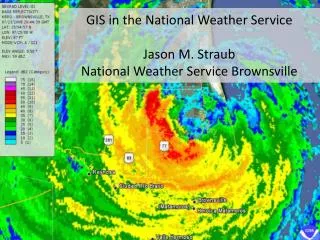
GIS in the National Weather Service Jason M. Straub National Weather Service Brownsville. National Weather Service – Weather Forecast Offices. Internal Use: Radar Operations Center: Wind Turbine Impacts to Doppler Weather Radar.

E N D
GIS in the National Weather ServiceJason M. StraubNational Weather Service Brownsville
Internal Use: Radar Operations Center: Wind Turbine Impacts to Doppler Weather Radar GIS use in screening and analyzing wind farm interaction with WSR-88D. NOAA: National Weather Service
Internal Use: Situation Awareness Displays Past Present
Publicly available data • www.weather.gov/gis • The National Weather Service’s repository for Shapefile and KML data • water.weather.gov • Daily precipitation shapefile
Shapefiles • Weather Warnings • Flash flood and precipitation guidance • Hurricane tracks and storm surge, and past hurricane tracks • Severe weather reports database
KML • NWS radar • Single image or loops • Multiple radars/nationwide imagery • Numerous products (radar, velocity, accumulated precip) • Current Weather Watches and Warnings • Automatically updated • Provides the text product associated with the advisory
KML • Local point forecast • Provides the graphical forecast for any point in the continental U.S.
KML • Hurricane data • Past tropical cyclone tracks • Tropical cyclone forecast models
Coming Soon • Daily High/Low/Precipitation • Hourly observations
Any Questions?? Jason M. Straub Meteorologist National Weather Service, Brownsville jason.straub@noaa.gov