Download
1 / 14
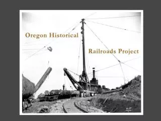
Oregon Lidar Mapping Atlas: Railroads & Slope Analysis
140 likes | 215 Vues
Explore Oregon's railroads using Lidar technology with slope analysis. This atlas showcases historical railroads, topography, and more. Discover the rich history of Oregon's railway networks.
Télécharger la présentation 
Oregon Lidar Mapping Atlas: Railroads & Slope Analysis
An Image/Link below is provided (as is) to download presentation
Download Policy: Content on the Website is provided to you AS IS for your information and personal use and may not be sold / licensed / shared on other websites without getting consent from its author.
Content is provided to you AS IS for your information and personal use only.
Download presentation by click this link.
While downloading, if for some reason you are not able to download a presentation, the publisher may have deleted the file from their server.
During download, if you can't get a presentation, the file might be deleted by the publisher.
E N D
Presentation Transcript
Bibliography and Credits Atlas of Oregon,William G. Loy, University of Oregon Press, Eugene, OR, 1976. Railroads in the Woods, John T. Labbe and Vernon Goe, Howell-North, Berkeley, CA, 1961. The Oregon-American Lumber Company: Ain’t No More,Edward J. Kamholz, Jim Blain and Gregory Kamholz, Stanford University Press, Palo Alto, CA 2003.


More Related