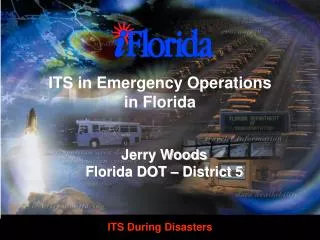
Using ITS in Helping Florida Manage Evacuations
560 likes | 689 Vues
Florida's emergency evacuation management is enhanced through coordinated procedures that prioritize public safety. Key strategies include timely identification of risk areas, consistent public communication, and effective multi-county traffic management. The implementation of designated evacuation zones and host shelters ensures a streamlined evacuation process, with focus on rapid clearance times across various counties. Utilizing state resources and real-time data, emergency teams collaborate to manage traffic flow and establish critical information dissemination points for affected residents, ensuring an organized response during emergencies.

Using ITS in Helping Florida Manage Evacuations
E N D
Presentation Transcript
Using ITS in Helping Florida Manage Evacuations Bob Collins Florida Division of Emergency Management
Holmes Jackson Escambia Santa Rosa Okaloosa Walton Gadsden Nassau Washington Hamilton Calhoun Leon Jefferson Bay Madison Duval Columbia Wakulla Suwannee Baker Liberty Taylor Union Clay Gulf Franklin Lafayette Bradford St. Johns Gilchrist Alachua Putnam Dixie Flagler Levy Marion Category 1 Clearance Times Volusia Citrus Lake Seminole Sumter Hernando Orange Pasco Clearance Times Under 10 Hours Brevard Osceola Hillsborough Pinellas Polk Indian River Manatee Hardee Okeechobee Clearance Times 10 - 18 Hours St. Lucie Highlands DeSoto Sarasota Martin Glades Charlotte Lee Hendry Palm Beach Clearance Times 18 - 24 Hours Broward Collier Miami-Dade Clearance Times Over 24 Hours Monroe
Holmes Jackson Escambia Santa Rosa Okaloosa Walton Gadsden Nassau Washington Hamilton Calhoun Leon Jefferson Bay Madison Duval Columbia Wakulla Suwannee Baker Liberty Taylor Union Clay Gulf Franklin Lafayette Bradford St. Johns Gilchrist Alachua Putnam Dixie Flagler Levy Marion Category 3 Clearance Times Volusia Citrus Lake Seminole Sumter Hernando Orange Pasco Clearance Times Under 10 Hours Brevard Osceola Hillsborough Pinellas Polk Indian River Manatee Hardee Okeechobee Clearance Times 10 - 18 Hours St. Lucie Highlands DeSoto Sarasota Martin Glades Charlotte Lee Hendry Palm Beach Clearance Times 18 - 24 Hours Broward Collier Miami-Dade Clearance Times Over 24 Hours Monroe
Holmes Jackson Escambia Santa Rosa Okaloosa Walton Gadsden Nassau Washington Hamilton Calhoun Leon Jefferson Bay Madison Duval Columbia Wakulla Suwannee Baker Liberty Taylor Union Clay Gulf Franklin Lafayette Bradford St. Johns Gilchrist Alachua Putnam Dixie Flagler Levy Marion Category 5 Clearance Times Volusia Citrus Lake Seminole Sumter Hernando Orange Pasco Clearance Times Under 10 Hours Brevard Osceola Hillsborough Pinellas Polk Indian River Manatee Hardee Okeechobee Clearance Times 10 - 18 Hours St. Lucie Highlands DeSoto Sarasota Martin Glades Charlotte Lee Hendry Palm Beach Clearance Times 18 - 24 Hours Broward Collier Miami-Dade Clearance Times Over 24 Hours Monroe
Regional Evacuation Procedures
Regional Planning Elements 1.Coordinated Decision Making 2. Consistency of Evacuation Zones and Routes 3. Multi-county Traffic Management 4. Risk / Host Sheltering Procedures 5. Consistent Public Information 6. Multi-County Re-entry
1. Decision Making Process: • Identification of Risk and Host • areas • Implementation of evacuations • Utilizing resources located in • non-vulnerable areas • Regional re-entry planning
2. A consistent state-wide • evacuation road network • 3. Coordinated traffic • management plans • FDOT, FHP and DEM working • with County Sheriffs Offices • Traffic Control Points • Barriers and barricades
4. Risk and Host Sheltering • Procedures • Host sheltering designated under a mission tasking from SEOC • All counties must develop Host Shelter Procedures • Shelter Manager Reserve
5. Consistent Public Information • PIOs in all affected counties • Coordination procedures among PIOs during events • Communicating emergency • information to evacuees • Regional coordination, consistent messages
Coordination • All counties in host regions will: • be directed by the SCO to activate • their EOCs to support local protective • actions • coordinate response activities with • each other and the SEOC • be included in all declaration • requests and Executive Orders
Coordination • All counties will: • develop a host response component • to their CEMP • be included in evacuatio coordination • conference calls • The Regional Evacuation Procedure will be updated to address host region response tasks
Traffic Management • All risk and host sheriffs included • Field report data from FHP Troops • Real time traffic counts from SEOC • Local incident management teams • to coordinate intersection staffing • and signal timing
Emergency Public Information • Identify critical sites for information within each region • Identify needed and available resources • FDOT flip-down shelter signs • Portable radio transmitters at all rest areas • FHP and FDOT PIOs taking a greater role in distributing information
FDEM WEB SITE: http://www.dca.state.fl.us/fdem Under Internet Library “SOP for Regional Evacuation”
Florida’s Contra Flow Operations • FDOT, FHP and DEM • Local input was solicited • FHP has command and control • DOT assisting FHP in developing operational plans • FLNG augmenting staff • I-10, Fl Tpk, Beeline and I-75 augmentation have been exercised
Timelines and Criteria • Must be cat 4 or higher • Must threaten more than one region. • Must have approximately 49 hours of setup time and operational time before arrival of tropical storm force winds. • Must have approximately 12 full hours of daylight to operate thecontra-flow plan.
Evacuation Information FDOT Interactive Real Time Traffic Counters Development of an interactive traffic model (Spreadsheet)
Traffic Counters • Located to provide advance • warning to receiving / host • jurisdictions • Necessary to monitor road • conditions and evacuation status • Necessary for evacuation • shutdown • Provide critical data for Travel • Demand Forecast Model
Traffic Counters www.dot.state.fl.us/ trafficinformation
Real Time Travel Demand Forecast Model (TDFM) • Developed under Hurricane Floyd • Post Storm Analysis by PBS & J • Interactive hurricane evacuation • decision making program • Data from consolidated hurricane • evacuation study transportation • analyses • Eventual capability to ingest traffic • counter data
TDFM Applications • To alert law enforcement and • DOT to potential trouble areas • on evac network • Public information • Host county impact analysis • Interstate impact analysis • Eventual contingency planning