Download
1 / 13
130 likes | 344 Vues
Structural and Dynamic Habitat in the Suwannee Estuary. Ellen Raabe, Randy Edwards, and Carole McIvor. Cooperative Effort. Cooperative data acquisition with FDEP FWS/USGS cooperative USGS Director’s Venture Capital Integrated science. Why Suwannee Estuary?.

E N D
Structural and Dynamic Habitat in the Suwannee Estuary Ellen Raabe, Randy Edwards, and Carole McIvor
Cooperative Effort • Cooperative data acquisition with FDEP • FWS/USGS cooperative • USGS Director’s Venture Capital • Integrated science
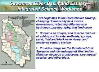
Why Suwannee Estuary? • Confluence of fresh and tidal waters (MFL) • Existing Research/FWS • Unique Setting and Ecological value • Recreation and Shellfish Industry • Opportunity for Integrated Science CASI imagery Suwannee Estuary Bands 9,7,5
An application of remotely sensed imagery to integrated habitat mapping • To map subtidal and intertidal habitat with hyperspectral imagery (CASI) • To link structural and dynamic habitat • To link habitat to fish ecology • To develop resource management tool
H A B I T A T Submerged flats Flooded low marsh Submerged limestone and high brackish marsh Tidal creek in forest
Habitat Map • CASI imagery • 4m, 12 bands • Habitats • Submerged • Emergent • Uplands • Bumblebee Creek • Barnett Creek
Estuarine Fish Ecology • Similar species composition North and South • Freshwater species in south tidal creeks • Seasonal and interannual variation? • Habitat use and preferences? • Dynamic habitat and benthic biota?
0-25 ppt Tidal lag into creeks 1.5 - 2 hours Net GW discharge At low tide Strongest signal in northern creek Need data: Water flow/depth WQ and salinity Sediment load Plankton Benthic biota Accessibility, duration, stability Dynamic Habitat
Flood zones • Submerged • Tidal creeks • Shallow flats • Low marsh • Brackish marsh • High marsh • Low elevation freshwater habitats
Future • Strengths of remotely sensed imagery • Low impact to habitat • Objective and large geographic coverage • Varied resolution and band selection • Topography, thermal, hyperspectral • Repeatability • quantitative change versus qualitative • habitat dynamics versus snapshot • Benthic Habitats: expand new field, new technique • to basin river bed, wetlands, uplands • to water source, quality and levels
Landscape Level Links • Bathymetry and topography - merge • Tidal and sea level dynamics • River discharge, groundwater and estuarine water quality • Geology and sedimentary process • from Ecosystem to Microhabitat • Wetland biota with habitat • Estuarine health and productivity
Detailed habitat and substrate features Management tool (FWS) Road impact Species habitat Tide levels and flood Coordinate with hydrology, biota, & geomorphic process studies Need: comprehensive mapping effort hydrologic monitoring and models (GW) spectral signatures of select features identification of key issues Summary
Potential Collaborators FWS FDEP FMRI UF USF SRWMD FGS USDA