Download
1 / 1
10 likes | 187 Vues
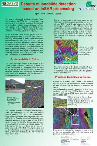
max. movement rates in line of sight of 14mm in 6 months. Baota landslide. Changjiang (Yangtze river). SRTM 3”- DEM data set overlayed on amplitude image Colour cycle change in height of 500m. Results of landslide detection based on InSAR processing Björn Riedel 1 and Kostas Lakakis 2.

E N D
max. movement rates in line of sight of 14mm in 6 months Baota landslide Changjiang (Yangtze river) • SRTM 3”- DEM data set overlayed on amplitude image • Colour cycle change in height of 500m Results of landslide detection based on InSAR processingBjörn Riedel1 and Kostas Lakakis2 The use of differential Synthetic Aperture Radar Interferometry (dInSAR) for the detection and monitoring of earth surface processes is meanwhile an established method. However, this approach has only success if the observed area fulfils specific requests, like sufficient backscattering, flat slope gradients or very slow growth of vegetation. In the European Union funded project OASYS -integrated optimization of landslide alert systems – the early identification of endangered areas plays the main important role (www.vce.at/oasys). For the recognition of surface movements one has decided to investigate the capability of dInSAR. Within the framework of this EU-project several test sites i.e. in Greece, Germany, Hungary, Rumania and China were investigated.Our InSAR investigations were especially focused on the Baota landslide in China and the Prinotopa landslides in Greece. The further processing levels were based on the differential interferometry approach using two or more coherent ERS 1 and 2 radar scenes for the final interferogram calculation. The different steps, like coregistration, filtering procedures, unwrapping, etc. were accompained by taking manual corrective actions, because the existence of two vegetation periods and the steepness of the terrain in this area were not the best boundary conditions for InSAR processing. The displacements on the Baota landslide of up to 14mm in six months from the InSAR processing were in extremely good coincidence with the geodetic derived movement rates. • satellites: ERS1 & ERS2 • image pair: 23424_06256 • January – July 1996 • baseline Bperp≈ 23 m • precise ephemeris Baota landslide in China The Baota landslide, located in the middle of the Three Gorges Reservoir, upstream of Dam site 223km, downstream of Chongqing 388km and sited on the left bank of the Yangtze river. A GPS and terrestrial network was established and measured three times. This geodetical data set was used for the validation of the InSAR results. The choosen approach consists of several levels of SAR data processing of the European Remote Sensing satellites ERS 1 and 2. At the beginning of the processing levels we used the subsampled 3sec-SRTM Digital Elevation Model (DEM) instead to our standard approach of using data of the ERS1/2 tandem mission for the DEM determination, because it turned out that we got more precise results. This DEM serves on the one hand as a necessary processing level for the further SAR processing and on the other hand as an important data source for the GIS in the alert system, e.g. for the derivation of slope parameters. Prinotopa landslides in Greece The test site is located in NW Greece in the province Ioannina and the new constructed Egnatia Motorway will pass this area. For the detection of landslides we used a modified3pass-Interferometry (baselines of 12 to 26m), consisting out of one ERS1/2-Tandem data set (January 1996) and an ERS2 image acquisition in April 1996 and Mai 1996. With an overlay of the two 3pass- results we got several identical clusters of pixels that showed us a change in colour in relation to their vicininty. These areas of earth surface changes of 2 up to 4cm are in good correlation with geological studies and geodetical on-site observations. Prinotopa landslide area Contact address: 1Technische Universität Braunschweig Institut für Geodäsie und PhotogrammetrieGaußstraße 22 38106 Braunschweig Germany b.riedel@tu-bs.de 2Egnatia Odos S.A. 6o Km Thessaloniki-Thermi P.O 57001 Thessaloniki Greece klakakis@egnatia.gr