Atlantic County, NJ Initial Coordination Meeting
180 likes | 299 Vues
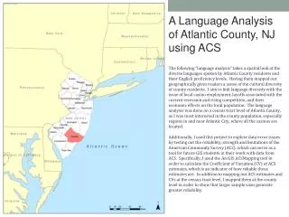
On November 9, 2010, a coordination meeting was held to enhance flood risk analysis and mapping in Atlantic County, NJ. The meeting aimed to establish awareness of ongoing efforts to update flood risk data through collaboration among federal, state, and local partners. Key participants included FEMA, NJDEP, and local mapping partners. Discussions focused on the objectives of the Risk MAP program, current project status, and necessary next steps to ensure accurate flood risk delineation. The meeting's success hinges on active participation from local communities in the flood risk management process.

Atlantic County, NJ Initial Coordination Meeting
E N D
Presentation Transcript
Atlantic County, NJ Initial Coordination Meeting FEMA Region II Mitigation Division November 9th, 2010 10:00-11:00
Risk MAP Vision: Through collaboration with State, Tribal, and local entities, Risk MAP will deliver quality data that increases public awareness and leads to action that reduces risk to life and property • Purpose of this Coordination Call: To establish the awareness and understanding in the ongoing efforts to update Community’s flood risk analysis and mapping (ie. FIS and DFIRM). • Whois Involved: Federal/State/Local/Mapping Partners • Federal – FEMA, Region II Project Manager; Paul K. Weberg, PE Communications/Outreach Support; Adie Koby Technical Assistance; Alan Springett • State – NJDEP, Joseph Ruggeri, PE, CFM Supervising Engineer NJ State NFIP Coordinator's Office Bureau of Dam Safety & Flood Control Office of Engineering & Construction • Mapping Partner: RAMPP – Milver Valenzuela, PMP, CFM, GISP - Project Manager • Local – Atlantic County & affected communities Purpose
WHY: maintain an up-to-date and accurate flood risk analysis and delineation for local decision makers in flood risk management. • This SUCCESS of this effort and outcome relies on the active participation of EACH COMMUNITY Purpose
Overview of current Risk MAP status of Atlantic County • Future projects and next steps • Questions & Feedback from the communities Objective
Mapping partner to deliver preliminary maps to the Atlantic County communities in August, 2012 • Project Team • Risk Assessment, Mapping, and Planning Partners (RAMPP), a joint venture of Dewberry, URS, and ESP • Tasks -Redelineation -Restudy of all coastal hazard zones -FIS Report Production -DFIRM panel and database production -Preliminary DFIRM Production and Distribution Atlantic County Preliminary Maps – Overview
Incorporation of approximately 59 miles of detailed riverine redelineation, 176 miles of approximate riverine redelineation, and 31 shoreline miles of detailed coastal analysis • Incorporation of NJFHA boundary to the DFIRM maps and Flood Insurance Report (FIS) profiles • The DFIRM and FIS report will be produced in the FEMA Countywide format in the North American Vertical Datum of 1988 (NAVD88) • NAVD 88 = NGVD 29 – 1.247 Atlantic County Preliminary Maps -Scope
Storm Surge: Analysis of tropical and extratropical (northeasters) using ADCIRC model and JPM statistical model • Topography and bathymetry complete • ADCIRC mesh is completed • Statistical analysis of storms nearing completion • ADCIRC modeling started in October 2010 • Overland Wave Hazard Analysis: Analysis of wave hazards along coastline. • Field reconnaissance complete • Obstruction polygon attribution is near completion Coastal Storm Surge and Overland Wave Hazard Analysis
Countywide paneling scheme with location of coastal influence for Atlantic County Atlantic County – August, 2012 PreliminaryPaneling Scheme
Atlantic County – NFIP Policies, Claims, Repetitive Losses, CRS, CAC & CAV - 1
Atlantic County – NFIP Policies, Claims, Repetitive Losses, CRS, CAC & CAV - 2
Current Status: • Coastal analyses are currently ongoing. Transect layouts have been defined. Draft obstruction polygons have been produced. Field reconnaissance has been completed • Approximate Hydrology and Hydraulics tasks have been initiated. Revisions to USGS regression equations (basis for the Approximate Hydrology) have delayed the progress as scheduled • Countywide LiDAR was acquired during the first weeks of April and final products are expected to be finalized by Spring of 2011. • Awaiting response from communities to the letters sent out in January, 2010 regarding data request Atlantic County Preliminary Maps -Current Status
Contacted each community letting them know about coastal field reconnaissance taking place in their communities in August 2010, and data request back in January 6, 2010 • Received response only from Atlantic County, Borough of Longport, City of Somers Point, and Township of Mullica • Is this an accurate representation of your communities? • Roles & Responsibilities of Local Communities: • Response to the letters sent out in January, 2010 • Flood Risk communications with residents Local Communities
Target Dates • Next coordination call: May, 2011 • Coastal Surge completed by: October, 2011 • Coastal Overland completed by: January, 2012 • Preliminary maps to be distributed: August, 2012 Milestones
Preliminary delivery • Community Consultation Official (CCO) meeting • Initial 30-day comment period • Appeals & Protests • 6 month: FEMA 6-month Letter of Final Determination (LFD) • 5 month: NJDEP Assistance Letter • 3 ½ month: Draft Ordinance • 3 month: NJDEP review of draft ordinance • 3 month: FEMA 90-day Reminder Letter • 1 month: FEMA 30-day Reminder Letter • 0: Ordinance Adopted The Road to Ordinance Adoption
NJ FY09 Projects • Similar meetings conducted: • Morris: April, 2010 • Bergen: June, 2010 • Somerset: June, 2010 • Essex: July, 2010 • Monmouth: August, 2010 • Union: August, 2010 • Cape May: September, 2010 • Passaic: October, 2010 • Middlesex: October, 2010 • Future coordination calls with: • Cumberland, Salem, Ocean Counties • Other project target dates for preliminary maps: • Morris and Bergen: June-September 2011 • Rest of the Counties: Early – Mid 2012 Recent Activities
www.RAMPP-TEAM.com: PowerPoint Presentation & Fact Sheets & additional information will be posted • Next coordination meeting: May, 2011 Contact Information • FEMA Region II Paul Weberg, DHS/FEMA Region II 290 Broadway, 29th Floor New York, NY (212) 680-3638 Paul.weberg@dhs.gov • NJDEP John Scordato / Joseph Ruggeri / Chris Gould NJDEP, Bureau of Dam Safety & Flood Control Phone: 609-292-2296 Fax: 609-984-1908 Visit NJDEP website: www.nj.gov/dep/floodcontrol Download Model Ordinances: http://www.nj.gov/dep/floodcontrol/modelord.htm • RAMPP Milver Valenzuela, PMP, CFM, GISP Study Manager 8401 Arlington Blvd. Fairfax, VA 22031 Phone: (703) 849-0463 Fax: (703)849-0648 mvalenzuela@dewberry.com Questions & Feedback