Download
1 / 41
410 likes | 782 Vues
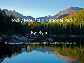
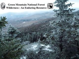
Green Mountain National Forest Wilderness : An Enduring Resource. What We Will Do :. Lay out the locations and some of the highlights of the six Green Mountain National Forest Wilderness areas. Discover the public purposes of wilderness.

E N D
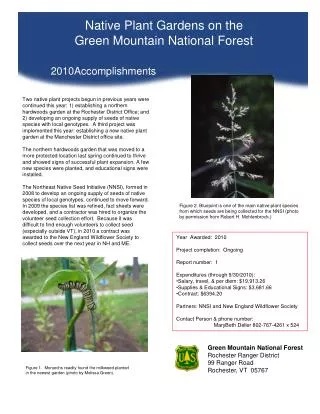
Green Mountain National Forest Wilderness : An Enduring Resource
What We Will Do : • Lay out the locations and some of the highlights of the six Green Mountain National Forest Wilderness areas. • Discover the public purposes of wilderness. • Examine wilderness character and some of the unique qualities found in Vermont Wildernesses. • Explore the role of Wilderness Rangers on the Greens and how they work to monitor and protect wilderness from threats to an enduring resource.
400,000 plus acres exist on the Green Mountain National Forest. • 60,000 acres is designated as Wilderness. • 15% of the Green Mountain National Forest is Wilderness.
Breadloaf Wilderness : Named after Bread Loaf Mountain at 3,835 feet. Climb Vermont's Presidential Range: Mounts Wilson, Roosevelt, Cleveland, and Grant. Moose and black bears live here in considerable numbers. Contains 17.4 miles of the Long Trail, four shelters and major side trails.
Big Branch Wilderness Named after Big Branch Stream. Located just west of the Peru Peak Wilderness. Separated by snowmobile Corridor 7. Contains about 6 miles of the AT/LT. 100 foot suspension bridge crosses Big Branch Stream. Big Branch and Lost Pond Shelters are on AT/LT. Lies in the White Rocks National Recreation area.
Peru Peak Wilderness Named after the highest mountain in the area. Contains 4 miles of the Appalachian/ Long Trail. Styles Peak has a view and Peru Peak is wooded. Pete Parent Peak, a 3,000-footer that, unlike most in Vermont, has no marked path to the top. Griffith Lake and Peru Peak shelter are located in between Big Branch and Peru Peak wildernesses with a Green Mountain Club Caretaker.
Lye Brook Wilderness Ranges from 900 feet to 2900 feet above sea level. The western section is extremely steep, facing west-northwest towards U.S. Route 7 and Manchester. The Appalachian/Long Trail skirts the northeast corner for about 3 miles. South Bourn Pond shelter removed in 2005. Remnants of railroad grades and old logging roads remain.
George D. Aiken Wilderness Named after the late senator who helped secure the Eastern Wilderness Act of 1975. Sits on a plateau rising as high as 2,300 feet. Land of ponds, meadows, hills and brushy forest. Popular for cross country skiing and snow shoeing in the winter. Like Bristol Cliffs, is managed without designated trails.
Bristol Cliffs Wilderness Named for unique cliffs on west side. Like the Aiken, is managed without designated trails. North Pond and Gilmore Ponds. Plane crash on South Mountain. Home to bears, moose, grouse, peregrine falcons and the tallest hobblebush in the state!
The 1964 Wilderness Act – Sec. 4(b) … wilderness areas shall be devoted to the public purposes of recreational, scenic, scientific, educational, conservation, and historical use.
…”devoted to the public purposes of recreational, scenic, scientific, educational, conservation, and historical use”
…”devoted to the public purposes of recreational,scenic, scientific, educational, conservation, and historical use”
…”devoted to the public purposes of recreational, scenic, scientific, educational, conservation, and historical use”
…”devoted to the public purposes of recreational, scenic, scientific, educational, conservation, and historical use” Leave No Trace Puppet Show and Hands-on Activity Station
…”devoted to the public purposes of recreational, scenic, scientific, educational, conservation, and historical use”
…”devoted to the public purposes of recreational, scenic, scientific, educational, conservation, and historical use”
Why Monitor Threats to Wilderness? A loss of naturalness and wildness maybe incremental but ultimately, in the long term, it is dramatic. Long term monitoring is essential to preserving what we have today and tomorrow. The Wilderness Act of 1964 mandates the Forest Service to preserve wilderness character.
Wilderness Character ..may bedescribed as the combination of biophysical, experiential, and symbolic ideals that distinguish wilderness from all other lands. These ideals form a complex set of relationships between the land, its management, and the meanings people associate with wilderness.”
Ten Year Wilderness StewardshipChallenge • Direction exists in either the Forest Plan or subsequent planning document, that updated or amended the Forest Plan, that addresses the natural role of fire in wilderness and considers the full range of management responses. • The wilderness was successfully treated for non-native, invasive plants. • Monitoring of wilderness air quality values is conducted and a baseline is established for the wilderness. • Priority actions identified in a wilderness education plan are implemented. • This wilderness has adequate direction, monitoring, and management programs to protect opportunities for solitude or primitive and unconfined recreation. • The wilderness has a completed recreation site inventory. • Existing outfitter & guide operating plans for the wilderness direct outfitters to model appropriate wilderness practices and incorporate appreciation for wilderness values in their interaction with clients and others. Needs assessments are completed for new operations or for major changes to existing outfitter programs. • The wilderness has adequate direction in the Forest Plan to prevent degradation of the wilderness resource. • The priority information needs for the wilderness have been addressed through field data collection, storage and analysis. • The wilderness has a baseline workforce in place.
Some Wilderness Ranger Activities to Protect Wilderness as an Enduring Resource • Abandoned Property , Human-made Structures and Trash Removal. • Campsite Condition Inventory and Monitoring. • Wilderness Boundary Monitoring and Signing. • Monitoring Motorized and Mechanical Equipment Trespass. • Advanced Technology : Following Geocaching. • Monitoring Pre-existing Special Use Authorizations, Recreation and Non-recreation Special Use Permits. • Finding and Documenting Illegal Trail Cutting. • Invasive Species Inventory and Removal. • Reports, Records and Data Entry.
Abandoned Property , Human-made Structures and Trash Removal
Campsite Condition Inventory and Monitoring • Digital Pictures • GPS Locations • Site Mapping, Measuring and Reference Points • Inventory of Area Damages
Monitoring Pre-existing Special Use Authorizations Non- Recreation Special Use Permits Recreation Special Use Permits
Invasive Species Identification and Removal Bush Honey Suckle Japanese Barberry Garlic Mustard Japanese Knotweed
Where does all this information go??? B. A. C. OR Click to the next slide please…and quick ->
Where does all this information go??? INFRA WILD : National Reporting Wilderness Regulations Report Wilderness Management Records Special Uses Summary Report Wilderness.net Web Links Summary Wilderness.net Public Contact Summary Accomplishment Report Summary
Wilderness Character Monitoring Tools It consists of developing two items : • Monitoring Selected Conditions Related to Wilderness Character: A National Framework for Monitoring” to improve wilderness stewardship . 2) A “Technical Guide for Monitoring with Selected Conditions Related to Wilderness Character” is being piloted this year in 2006 and being put into national implementation in 2007.
What We Have Done : • Laid out the locations and some of the highlights of the six Green Mountain National Forest Wilderness areas. • Discovered the public purposes of wilderness. • Examined wilderness character and some of the unique qualities found in Vermont Wildernesses. • Explored the role of Wilderness Rangers on the Greens and how they work to monitor and protect wilderness from threats to an enduring resource.
Where to Get More Information www.wilderness.net • Middlebury Ranger District, 1007 Route 7, Middlebury, Vermont 05753-8999. (802) 388-4362. • Rochester Ranger District, 99 Ranger Road, Rochester, Vermont 05767-9431. (802) 767-4261. • Green Mountain and Finger Lakes National Forests Supervisors Office, 231 North Main Street, Rutland, Vermont 05701-2417. (802) 747-6700. • Manchester Ranger District, 2538 Depot Street, Manchester Center, Vermont 05255-9419. (802) 362-2307. Ken Norden Scott Haas