Download
1 / 14
140 likes | 360 Vues
Project Overview I-95 Corridor Coalition Vehicle Probe Project. AASHTO SSOM - 2009 Rick Schuman. I-95 Corridor Coalition. A partnership of transportation agencies from Maine to Florida with affiliates in Canada Formed in 1993 Region has a $4.5 Trillion economy

E N D
Project OverviewI-95 Corridor Coalition Vehicle Probe Project AASHTO SSOM - 2009Rick Schuman
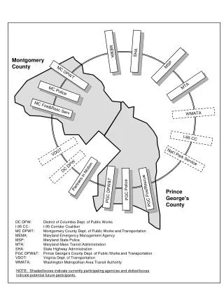
I-95 Corridor Coalition • A partnership of transportation agencies from Maine to Florida with affiliates in Canada • Formed in 1993 • Region has a $4.5 Trillion economy • Model for interagency cooperation and coordination since the early 1990’s • Volunteer organization • Based on four “C’s” • Consensus • Cooperation • Coordination • Communication http://www.i95coalition.org
Vehicle Probe Project • From Request for Proposal: • “The Coalition is supporting… • a regional traffic monitoring system… • a continuous source of real-time transportation system status information within the Corridor. • …will serve as a rich source of traveler information and will provide invaluable inputs to existing and future management tools…. • It is the intent of the Coalition to encourage innovative, non-invasive detection technology, while taking advantage of existing data where available.”
Timeline/Milestones • Procurement Process • RFIs: October 2006, February 2007 • RFP Published: April 2007 • Proposals Submitted (5): June 2007 • Contract Awarded: December 2007 • Early Project Milestones: • Initial Task Order: February 2008 • NJ Expansion Task Order: June 2008 • Service Operational: July 1, 2008 • Initial Validation: July – October 2008 • NC Expansion Task Order: November 2008 • SAFETRIP Task Order: January 2009 • Initial Validation Results Published: January 2009
Contract 3 years – options to 10 years Task Order contract with U of Md Member agencies can: Expand coverage, Add source data Access consulting services, Extend project duration Core Task Traffic data feed Monitoring web site Data archive Coverage ~1500 freeway miles ~1000 arterial miles (donated) Project Highlights
Project Highlights (2) Costs • Mobilization: $150/centerline mile • Annual Fee: $750/centerline mile Use terms • Codified in Data Use Agreement (DUA) • Full use rights for agencies • All members see all coverage • No redistribution to 3rd parties Data Feed – XML Stream • Content • Speed, Travel Time, Real-Time “Score” • Expected Speed, Free Flow Speed • Road Segments • “TMC” location codes • Update Rate/Latency • Agencies access ~ every 1 mins • Per Project Interface Guide Monitoring Site • Agency access only • View all data in real-time • Pure browser-based • Access to data archive
Project Requirements RFP Requirements Validation • Next Presentation… What • Avg Error ± 10 MPH • Avg Bias: ± 5 mph • For 4 Bins: <30, 30-45, 45-60, >60 MPH • Latency: ≤ 8 minutes • Update Rate: ≤ 5 minutes • Data Reliability: ≥ 95% • Data Availability: ≥ 99% When • Flow > 500 VPH on a segment Where • Core Freeways, Expansions • Not Core Arterials
Project Status New…Traffic Tile Overlays/SAFETRIP Current Coverage • Freeways: ~ 3500 Centerline miles • Arterials: ~ 900 Centerline miles • From NJ to NC • ~ 10,000 Road Segments Data Access (through 5/26) • 12 agencies executed DUA • 162 monitoring site users • 28 data feed users Availability since July 1, 2008 • Monitoring Site: 99.90%+ • Data Feed: 99.93%+ www.i95travelinfo.net
Friday, Memorial Day Weekend (2009) Incident I-95 in Southern VA New York City/Northern NJ Exodus
Summary/Looking Forward • Breakthroughs/Models for Others • Data and Performance Requirements • Proves Technology Approach – GPS Probe data viable • Multi-agency procurement • Broad coverage – using consistent location referencing • “Beyond border” coverage • Data Use Terms/Data Use Agreement • Validation Approach • Focus Going Forward • Ongoing validation – improvements based on findings • Applications/Uses of Data • Project Expansion • North and South of current coverage area • Going deeper in coverage area
Contacts Project Contacts • I-95 Corridor Coalition • Bill Stoeckert: 774‐207‐0367; wstoeckert@yahoo.com • University of Maryland • Stan Young: 301‐403‐4593; seyoung@umd.edu • INRIX • Rick Schuman: 407‐298‐4346; rick@inrix.com Project Information • www.i95coalition.org
Project OverviewI-95 Corridor Coalition Vehicle Probe Project AASHTO SSOM - 2009Rick Schuman