Download
1 / 27
270 likes | 393 Vues
I-95 Corridor Coalition Vehicle Probe Project Agency Reflections. AASHTO SSOM - 2009 William W. Stoeckert. Overview. Agency Use of Data/Applications Agency Reflections New Jersey Maryland North Carolina SafeTrip 21 Conclusions. Agency Use of Data/Applications.

E N D
I-95 Corridor Coalition Vehicle Probe Project Agency Reflections AASHTO SSOM - 2009William W. Stoeckert
Overview • Agency Use of Data/Applications • Agency Reflections • New Jersey • Maryland • North Carolina • SafeTrip 21 • Conclusions
Agency Use of Data/Applications • Monitor travel times and speeds • Post travel information to agency websites • Provide travel times on DMS/VMS • 511 & operations • Planning functions • Performance measures
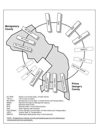
Agency Reflections • New Jersey • Maryland • North Carolina
NJDOT Perspective James R. Hogan, PE Executive Director Statewide Traffic Operations, NJDOT
NJDOT Traffic Operations 2700 linear miles (2300 DOT) 800 Freeway/Toll miles Two Operations centers (Co-located with NJTA) NJ511.INFO
NJDOT - What They Needed and Why Most densely populated state in US Most DMS statewide w/o travel times Need instrumentation Need incident detection other than ESP, PD and the media Limited resources to instrument the entire system Could not handle the O&M of statewide instrumentation
What NJDOT Did! Leveraged the I-95 Vehicle Probe Contract 958 miles covered (DOT & Authority) 534 miles by I-95 CC Addl. 424 miles ($1.2M for 3 years) Went from less than 5% to 35% covered Displayed in NJ TOCs to monitor the system
What NJDOT is Doing Incident Detection alerts from systems Travel speeds on 511/Web Interactive Travel times on 511/web Expanding instrumentation as needed to supplement INRIX and existing. Data Fusion of INRIX, RTMS, Transmit and other traffic data systems to feed 511/Web and DMS
NJ Story - saves $100K in User Costs • Reduced delays and no secondary incidents • Estimated roughly a one-hour reduction in incident detection time • translated to a $100,000 savings to users • Without the I-95 CC/INRIX data, the incident would have gone undetected for a foreseeable time.
What NJDOT Learned Leveraging this contract worked I-95 Corridor Coalition VP data by INRIX gives us a Statewide view of the transportation system not had previously Need other means of detection to fill-in
Maryland Richard R. Dye Maryland State Highway Administration
1988 - Reach the Beach w/State Highway & State Police CHART History 2009 - Real-Time 3rd Party input for Travel Times and Toll Rates on DMS
Travel Times on DMS • I-95 VP data facilitated schedule acceleration • Travel Times on DMS application was scheduled for FY 2012 • Engineering guidelines for implementing travel times On DMS in Maryland in process
October 2009 Implementation Traveler Information Messages, including Travel Times and Toll Rates obtained via an external connections to systems including I-95 VP project/INRIX.
Bridging NC’s Data Gap Jo Ann OerterState ITS Operations Engineer NCDOT ITS America – June 2, 2009
Where NCDOT Was….. • 50 miles in the Charlotte area • 75 miles in the Raleigh area • 125 miles / 1100 miles = 11% covered
Where NCDOT Needs To Be….. • ALL INTERSTATES • 1100 miles of coverage
Why NCDOT Needs More….. • SECTION 1201 - Real-time System Management Information Program • Customer Expectations • Performance Measures • Better Management Of Roadways
How Data Is Used… • Incident Detection • Travel Information • Website • 511 • DMS • Route/Corridor Management • Event and Emergency Management • Planning
Incident Detection DETECT: in areas not covered or have gaps in ITS coverage • VERIFY: • Dispatch IMAP • Communicate with Law Enforcement
Hurricanes • Inauguration • etc…. Event And Evacuation Management
Other Benefits….. • IMPROVED COMMUNICATION AND COORDINATION • NCSHP • Law Enforcement • Emergency Responders • Municipalities • Other States • NCDOT
SafeTrip 21 • Long-distance Trip Planning Website • www.i95travelinfo.org • Public displays (coming later this summer) • Tyson's Corner Center • Virginia Welcome Centers along I-95 • Fredericksburg • Skippers • BWI ground transportation kiosks • Mobile devices
Conclusions • I-95 Corridor Coalition is excited by the progress • Encourages the use of VP data by its members • Looks forward to continued system expansion and continued use.