Download
1 / 97
980 likes | 1.21k Vues
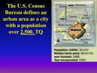
The U.S. Census Bureau defines an urban area as a city with a population over 2,500. TQ.

E N D
The U.S. Census Bureau defines an urban area as a city with a population over 2,500. TQ
World's largest citiesThe question of determining the world's largest cities does not allow a single, simple answer. It depends on which definitions of "city" and "size" are used, and how those definitions are applied. Complex political/cultural/social situations, sometimes controversial or disputed, further confuse the discussion. Debate on this field is highly vulnerable to bias or manipulation, as people tend to prefer whichever definition most flatters their own city.The "size" of a city can refer to either its land area or, more typically, its population.The borders of a city can be defined several ways:
Administrative "City" as strictly defined by a given government (city proper). Typically based on a municipality or equivalent entity, or sometimes a group of municipalities under a regional government.
Morphological"City" defined as a physically contiguous urban area, without regard to territorial or other boundaries. The delineation is usually done using some type of urban density, such as population density or density of buildings. Satellite and/or aerial maps may be used. For statistical convenience, such areas are sometimes adjusted to appropriate administrative boundaries, yielding an agglomeration.
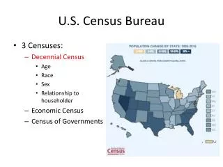
The High Desert The Valley San Gabriel Valley The East Side LA South Central The South Bay Orange County
Functional"City" as defined by the habits of its demographic population, as by metropolitan area, labor market area, or similar. Such definitions are usually based on commuting between home and work. Commuter flow thresholds into the core urban area are established by the national census authority, determining which areas are included.
Metropolitan statistical area (MSA) 1. A central city with a population of at least 50,0002. its county (within which the city is located)3. Adjacent counties in which at least 15 percent of the residents work in the central city’s county
The United States Census Bureau has designated the five county region as the Los Angeles-Long Beach-Riverside combined statistical area, with a July 1, 2006 population estimate of 17,776,000.
The United States Office of Management and Budget (OMB) has defined 125 Combined Statistical Areas (CSAs) for the United States of America. The OMB defines a Combined Statistical Area as an aggregate of adjacent MSAs that are linked by commuting ties. The Combined Statistical Area is the most expansive of the metropolitan area concepts. Not CMSA
The Greater Los Angeles Area, or the Southland, is the agglomeration of urbanized area around the county of Los Angeles. Greater Los Angeles includes the Los Angeles metropolitan area, the Inland Empire, and the Oxnard–Thousand Oaks–Ventura area. San Diego and Imperial counties, while a part of Southern California, are not included in this agglomeration.
Megalopolis: large metropolitan areas so close together that they form one continuous urban complex
America’s Megapolitan Regions These ten megapolitan regions account for almost 70% of the U.S. population in less than 20% of the land area.
Japan’s “Tokaido Megalopolis,” named for the old Tokaido Road running from Yedo (Tokyo) through Osaka and southwest to Nagasaki, includes some of the country’s largest cities (like Kyoto, the historic capital of the country). The megalopolis contains more than 50 million people and accounts for more than 80 percent of Japan’s total GDP.
Parts of an Urban Areacentral business district (CBD): the central nucleus of commercial land uses in a city.
FR What activities and structures are typically found in a city’s Central Business District (CBD)? CBD Activities: Business services
Why are these activities and structures located in the CBD? Accessibility (can support services with a large threshold and range)
zone in transition: area of mixed commercial and residential land uses surrounding the CBD. • Warehouses
Apartment buildings • public housing New York from Bronx
Older residential neighborhoods • gentrified buildings
Suburbs are residential areas surrounding a large urban area.
Edge cities: nodal concentrations of shopping and office space that are situated on the outer fringes of metropolitan areas, typically near major highway intersections.
FR What kinds of activities and structures are typically found in Edge Cities? FR How do CBDs and Edge Cities differ? Edge cities: suburban downtowns activities: • Shopping • office space/jobs • Entertainment Edge City: Tysons Corner, Virginia