D2.1 Deliverable
760 likes | 936 Vues
D2.1 Deliverable. WP2 Contents. No input from other work packages Data Provided for WP4 (Functional Specifications). Deliverables:D.2.1. Report on the operational requirements. Deliverables-Milestones-Deadlines. WP2 Objectives. Define: Envelope of Operational Conditions

D2.1 Deliverable
E N D
Presentation Transcript
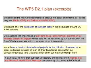
WP2 Contents • No input from other work packages • Data Provided for WP4 (Functional Specifications) • Deliverables:D.2.1. Report on the operational requirements Deliverables-Milestones-Deadlines DIFIS PROJECT
WP2 Objectives • Define: • Envelope of Operational Conditions • Preparation of Operational /Users Requirements & Specifications DIFIS PROJECT
Envelope of Operational Conditions • Environmental Conditions • Sea • Surface • Seabed • Cargo Carried • Type • Quality • Quantity • Wreck • Leakage Rate/SIze • Double Hull/Single Hull DIFIS PROJECT
Sea • Common Accidents Sites • Conditions in these accidents sites • Common accident sites • Sources • IMO • CEDRE • Republic of Latvia • Tanker Traffic Routes • Conditions in Accident Sites • Depth • Season • Temperature • Salinity • Waves • Water Currents • Wind Speeds DIFIS PROJECT
Common Accident Sites • World Map of Tanker Accidents (IMO-CEDRE- Republic of Latvia (Baltic Sea) DIFIS PROJECT
European Coasts • Main Accident Sites: • Atlantic Coasts of Spain & France 2. North Sea & Baltic Sea 3. Mediterrenean DIFIS PROJECT
Division of European Sea bodies • Atlantic Coasts • North Sea(s) • Mediterranean Sea • North Atlantic Ocean DIFIS PROJECT
Oil Spills In European Waters DIFIS PROJECT
Tanker Traffic Routes DIFIS PROJECT
Depth-Radar Altimetry Deeper Waters: Area 1 Source: www.gesource.ac.uk DIFIS PROJECT
Detailed Bathymetry of the coastal Spain & France Source: IFREMER Website www.ifremer.gr DIFIS PROJECT
Detailed Bathymetry of the Mediterrenean Does IFREMER have a similar to the Spain & France coasts map of the Mediterranean & North Sea? DIFIS PROJECT
Season Source : CEDRE “ANALYSIS OF THE MAIN MARITIME ACCIDENTS HAVING LED TO PAST POLLUTION OF THE EUROPEAN WATERS WITH PARTICULAR EMPHASIS ON THE ASPECT OF POLLUTING WRECKS” prepared for IFREMER in the framework of the DIFIS project Winter and Autumn cover the 57% of maritime accidents The DIFIS Deployment will most likely be conducted in harsh weather conditions DIFIS PROJECT
Temperature – Buoy Data I Coriolis Data Server – 10m depth September October November February January December DIFIS PROJECT
Temperature – Depth Variation Coriolis Data Server (access through IFREMER website) 10 m 100 m 300 m Sea Surface Data Available through IFREMER Live Access Server has also been collected 1000 m DIFIS PROJECT
Salinity • Data is available online through the CORIOLIS data server (for different depths) • To be Implemented in Deliverable 2.1 Salinity is also Varied by depth Importance of Salinity: % of Salt defines the density of Sea water Defines the velocity of the oil DIFIS PROJECT
Wave Height -40 year averages October November September February December January DIFIS PROJECT
Wave Height -Numerical Data Wave height is in meters DIFIS PROJECT
Wave Period – Radar Altimetry Data I October November September February December January DIFIS PROJECT
Wave Period-Numerical Data Wave period is in seconds DIFIS PROJECT
Quantity Source: CEDRE Report DIFIS PROJECT
Spills below 700 tones DIFIS PROJECT
Spills over 700 tones • Source: ITOPF statistics DIFIS PROJECT
Source: ITOPF Assumption: All small accidents are of 350 tn (the average of the range) DIFIS PROJECT
Source: ITOPF An accident of 100,000 tones is forseeable DIFIS PROJECT
Cargo-Quality 83% of the oil spilt is CRUDE OIL 37% of the oil spills involve CRUDE OIL Source: CEDRE report DIFIS PROJECT
Cargo-Quality Source:CEDRE report Large Accidents Involve Crude Oil & Heavy refined Oil Very Large Accidents > 100000 tn involve only crude oil Oil spills between 10000 and 100000 tn Oil spills over 100000 tn DIFIS PROJECT
Type of Oil The main causes of pollution is spills over 10000 tonnes Number of Accidents Multiplied by Mean oil amount range DIFIS PROJECT
Oil Properties (In summary) • Density – Characterises the buoyancy of the cargo (Flow Models) • Dynamic Viscosity – (can characterise the oil flow through the riser tube and from the buffer bell to the tanker) • Surface Tension (Charecterises the resistance to flow between the riser and oil) • Adhesion (How much will the oil become attached to the riser and the buffer bell) • Variables • Temperature • Oil weathering (~evaporation) Dynamic Viscosity Density Surface Tension Adhesion Rising Temperature Increased Oil Weathering DIFIS PROJECT
Maximum oil Properties DIFIS PROJECT
Vessel Sizing >50000 ~80000 125000-180000 300000 >300000 VLCCs and ULCCs represent great danger in terms of oil amount • Large tankers usually carry crude oil • CEDRE reports that heavy refined oil traffic with large tankers is increasing DIFIS PROJECT
Single Hull- Double Hull • ITOPF projections identify that only 25% of tankers will be single hull in 2007 DIFIS PROJECT
Leakage Rate and Wreck Condition • Leakage rate highly depends on the specific accident. • The PRESTIGE accident involved a leakage rate of 125 tn/day • Pre-intervention monitoring should provide data for leakage rate • According to conditions, leaks will be sealed/ created in order to keep leakage to the DIFIS operational specifications • If the tanker is Double Hull, great possibility of intact fuel tanks • ULCCs and large tankers pose the risk of being cut in half DIFIS PROJECT
Location Weather Conditions Type and amount of Oil Pattern / rate of Spillage Clean Up Response Response on / off shore Termination of clean-up Operation Oil Pollution compensation Consequences Economical Ecological • Effects of Oil on Flora • Consequences on Coral Reefs and Beaches • Effects on Fauna • Toxic Contamination • Destruction of food chain DIFIS PROJECT
Main Events DIFIS PROJECT
Points of Discussion Maximum Operating Conditions • Maximum Working Depth: 4000 m • Seabed : All compositions (anchoring system dependant) • Weather Conditions (Design conditions AREA 1) • Amount of oil to be reclaimed :~300000tn • Wreck status : irrelevant .Only provision : wreck immobile • Design cargo : heavy crude oil –heavy refined oil • Deployment time (depends on the readiness of the system) • Deployment currents : 2-3 kt (max ROV working condition) • Vessel Type : ULCC (possibility of double hull) Should M/V bunker tanks be considered as intervention targets? DIFIS PROJECT
Organizational Interactions With Other WPs • No input from other work packages • Data Provided for WP4 (Functional Specifications) • Partners Involved: • MARIN • IFR • ISI Deliverables-Milestones-Deadlines D.3.1. Report on technology state of the art. M.0. Requirementsand State of the Art DIFIS PROJECT
Objectives 4 Provide pool of Technological Solutions for Integration to the DIFIS Project 3 2 1 DIFIS PROJECT
Structure of WP3 • Surface • Geopositioning / Support Vessels • Deployment / Fabrication / Assembly • Underwater • Anchoring • ROV • Flow Models • Materials • Oil • Mooring lines • Risers / Interfaces • Fabric for the Dome/Riser • Support • Logistics • Telecoms • Planning Tools • Monitoring & Control DIFIS PROJECT
Wreck survey, salvage and removal Pre or Post operational survey Survey and ROV Support Subsea installation (cable, anchoring) Shuttle tanker offtake Mobile offshore Drilling Offshore loading tankers Floating Production Storage and Offtake Geopositioning Vessel Operations: DIFIS PROJECT
Anchoring In General ANCHORING CONFIGURATIONS Catenary Systems Taut Leg Systems DIFIS PROJECT
Geotechnical Aspects USS= Undrained Shear Strength UCS= Unconfined Compression Strength Property table : IFREMER DIFIS PROJECT
Suction Anchors DIFIS PROJECT
Drag Embedded anchor Specialized design should be done by the manufacturer / operator No significant uplift capacity (catenary systems) DIFIS PROJECT
Vertical Load Anchor Installation Retrieval DIFIS PROJECT
Other anchor types Not widely used The major uncertainties are in the estimation of the trajectory, ultimate anchor depth, and final anchor orientation. Combination of suction anchors and Plate Anchors Seems to be very promising as a solution DIFIS PROJECT
Anchoring Solutions Comparison Seabed determines the anchoring configuration DIFIS PROJECT
Remotely Operated Vehicles-Surveying • Surveying Operations Required Anticipated • Position, depth and integrity of the wreck • Seabed stability, geology and geography-Identification of anchoring Sites • Oil amount and type remaining, leakage rate and position of the leaks • General inspection and preparation for the deployment • Possible inspection of the DIFIS main dome integrity after deployment and in periodic checks • Sensors • Cameras for optical surveillance • Sediment echo sounders, series of Piston coring and Mini cone-penetration testing • Measurement capabilities including distance, orientation, elevation, leak flow, temperature • Sensors to calculate the amount of oil remaining in the wreck (possibly sonar?) • Capability of taking oil samples from the wreck’s tanks in order to define the composition of the cargo remaining. This might require special custom designs compatible with ROV standard manipulators. DIFIS PROJECT