HRU Delineation and Parameterization for Hydrologic Modeling
Utilize distributed parameter approach for HRU delineation, considering slope, aspect, elevation, vegetation, and more. Derive HRU parameters like topography, land use, and vegetation using various methods for effective hydrological modeling.

HRU Delineation and Parameterization for Hydrologic Modeling
E N D
Presentation Transcript
HRU Delineation • Hillslope/Drainage Focus • Subbasins • Cascade HRUs (surface, gw) • Water Bodies • Parameter Types/Classes • Topographic • Non-topographic • Parameter Complexity • Single Factor • Multiple Factor • Visible/Modifible Estimation Methods • Output File Structure Parameterization Issues
Distributed Parameter Approach Hydrologic Response Units - HRUs HRU Delineation Based on: - Slope - Aspect - Elevation - Vegetation - Soil - Precip Distribution
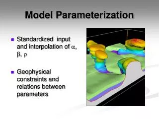
Dill Basin, Germany Topography 750 km2 Sub-basins Land Use
PRMS -- HRU Delineation Pixelated Topographic
HRU resolution PRMS SSR resolution GWR resolution
CASCADING FLOW PLANES 1 2 3 1 7 8 Overland Flow Path 10 9 1 Channel Segment 3 Channel Junction 4 3 6 2 Overland Flow Plane 2 4 width Grass/Agriculture Bare Ground/Rock 5 12 11 Trees length Shrubs
MODEL RECIPE FILE PARAMETER ESTIMATION METHOD PARAMETER
Multiple Factor Parameter (available water holding capacity of soil zone) Recharge Zone soil_moist_max Lower Zone • Function of: • Vegetation Type • Vegetation Rooting Depth • Soil Field Capacity • Soil Wilting Point
DIGITAL DATABASES STATSGO Soils (USDA) Vegetation Type (USFS) Satellite SW Radiation (U Md) Vegetation Density (USFS) Land Use-Land Cover (USGS) Monthly PET
GIS WEASEL • Parameterization: • 200+ methods available • Easily add custom methods • Exploit many types of data • Produce maps and ASCII files of parameters • Configure recipes • Apply to feature maps +
Visible/Modifible Estimation Methods (conceptual) Map Window Project Browser HRU 15 Selected Click to display method Equation Box – Edit Method Data Table Filters Parameter Table