Download
1 / 2
20 likes | 128 Vues
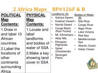
This resource provides engaging activities to explore Africa's geography. Learn by drawing and labeling 10 African countries and identifying neighboring continents. Discover significant landforms, including the Sahara and Kalahari Deserts, the Congo Basin, and iconic features like Mount Kilimanjaro and the Ethiopian Highlands. Additionally, locate major bodies of water such as the Nile and Congo Rivers, and label the Atlantic and Indian Oceans. Perfect for students to enhance their understanding of Africa's physical and political landscapes.

E N D
2 Africa Maps BP#126F & B POLITICAL Map Contents: • Draw in and label 10 African countries • Label the locations of other continents surrounding Africa Landforms (9) • Sahara Desert • Kalahari Desert • Namib Desert • Congo Basin (Rain Forest) • Mt. Kilimanjaro • Atlas Mts. • Ethiopian Highlands • Sahel (Grasslands) • Serengeti Plains Bodies of Water (8) • Nile River • Congo River • Niger River • Lake Victoria • Red Sea • Mediterranean Sea • Atlantic Ocean • Indian Ocean PHYSICAL Map Contents: • Locate and label landforms and bodies of water of SSA • Make a key showing land cover in SSA
1. Zimbabwe 2. Sudan 3. South Africa 4. Egypt 5. Dem. Rep. of Congo 6. Somalia 7. Nigeria 8. Libya 9. Rwanda 10. Ivory Coast BP#123 Map: Use a book - In which African sub-region is?